Fine Art Print > Animals > Insects > Hemiptera > Hemispherical Scale
Fine Art Print : Venus radar map, North Pole

![]()
Fine Art Prints from Science Photo Library
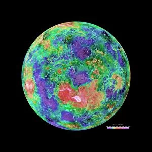
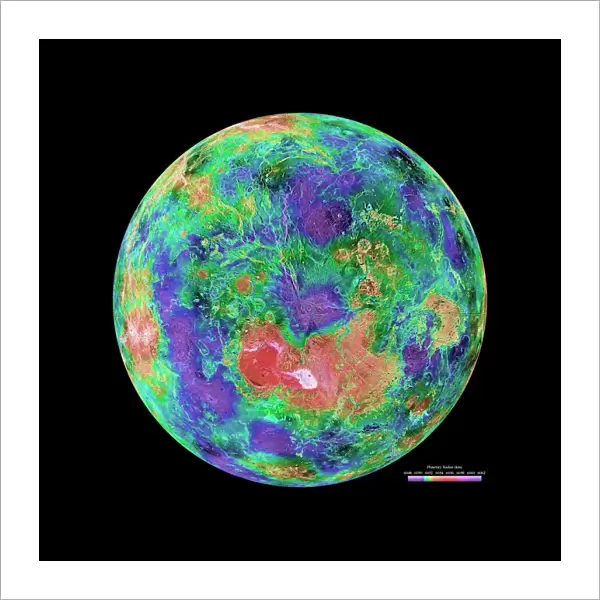
Venus radar map, North Pole
Venus radar map, centred on the Venusian North Pole. The map is colour-coded for altitude, going from low altitude (purple) through blue, green, yellow and orange to high altitude (red). The scale is at lower right. Most of this map was created using radar data gathered by the Magellan spacecraft from 1990 to 1994. Gaps in the coverage were filled in using data from earlier missions and Earth-based radar telescopes. This map is part of a set of six radar maps of Venus: see images R334/184 to R344/189
Science Photo Library features Science and Medical images including photos and illustrations
Media ID 1694513
© NASA/JPL/USGS/SCIENCE PHOTO LIBRARY
1990s Altitude Circle Circular Colour Coded Colours Elevation Geological Hemisphere Magellan Imagery Mapping Mosaic Mountains North Pole Northern Hemisphere Planetary Planetary Science Polar Region Probe Radar Round Satellite Solar System Space Craft Topographical Topography Valleys Venus Venusian Magellan
20"x20" (+3" Border) Fine Art Print
Discover the enchanting world of Venus with our Fine Art Prints from Media Storehouse. This captivating image of Venus' radar map, North Pole, brings the mystique of our sister planet closer than ever before. Colour-coded for altitude, the map reveals intriguing topographical details, from low altitude purples and blues to the towering reds of high altitude areas. Bring the wonders of space into your home or office with this stunning, high-resolution print. Experience the beauty and complexity of Venus like never before.
20x20 image printed on 26x26 Fine Art Rag Paper with 3" (76mm) white border. Our Fine Art Prints are printed on 300gsm 100% acid free, PH neutral paper with archival properties. This printing method is used by museums and art collections to exhibit photographs and art reproductions.
Our fine art prints are high-quality prints made using a paper called Photo Rag. This 100% cotton rag fibre paper is known for its exceptional image sharpness, rich colors, and high level of detail, making it a popular choice for professional photographers and artists. Photo rag paper is our clear recommendation for a fine art paper print. If you can afford to spend more on a higher quality paper, then Photo Rag is our clear recommendation for a fine art paper print.
Estimated Image Size (if not cropped) is 50.8cm x 50.8cm (20" x 20")
Estimated Product Size is 66cm x 66cm (26" x 26")
These are individually made so all sizes are approximate
Artwork printed orientated as per the preview above, with landscape (horizontal) or portrait (vertical) orientation to match the source image.
FEATURES IN THESE COLLECTIONS
> Animals
> Insects
> Butterflies
> Mission Blue
> Animals
> Insects
> Hemiptera
> Green Scale
> Animals
> Insects
> Hemiptera
> Hemispherical Scale
> Animals
> Insects
> Hemiptera
> Purple Scale
> Animals
> Insects
> Hemiptera
> Yellow Scale
> Maps and Charts
> Early Maps
> Maps and Charts
> Geological Map
> Maps and Charts
> Related Images
> Science
> Space Exploration
> Planets
> Earth
> Science Photo Library
> Space
EDITORS COMMENTS
This print showcases a detailed radar map of Venus, specifically centered on its North Pole. The map is an exquisite display of colors representing different altitudes, ranging from low altitude depicted in purple to high altitude illustrated in red. At the lower right corner, a scale provides a reference for measurement. The majority of this remarkable map was constructed using radar data collected by the Magellan spacecraft during its mission from 1990 to 1994. To ensure comprehensive coverage, any gaps were filled using information obtained from previous missions and Earth-based radar telescopes. This particular map is part of a set comprising six radar maps that offer valuable insights into the topography and geological features of Venus. Its circular mosaic design beautifully captures the planet's unique characteristics and aids in understanding its geographical composition. As we explore this image further, it becomes evident that mountains and valleys are scattered across Venus' surface. The creation of such intricate maps has been made possible through advanced radar mapping techniques employed by probes like the Magellan spacecraft. By studying these maps, scientists gain invaluable knowledge about our neighboring planet's northern hemisphere and polar region. With its vibrant colors and meticulous detailing, this stunning print serves as a testament to humanity's ongoing exploration of our solar system while highlighting the wonders hidden within Venus' mysterious landscape.
MADE IN THE USA
Safe Shipping with 30 Day Money Back Guarantee
FREE PERSONALISATION*
We are proud to offer a range of customisation features including Personalised Captions, Color Filters and Picture Zoom Tools
SECURE PAYMENTS
We happily accept a wide range of payment options so you can pay for the things you need in the way that is most convenient for you
* Options may vary by product and licensing agreement. Zoomed Pictures can be adjusted in the Cart.