Framed Print > Animals > Fishes > Related Images
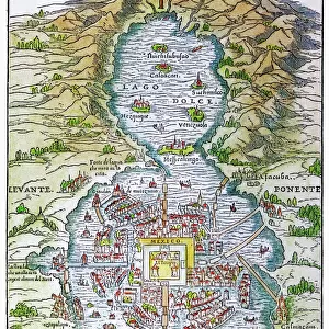
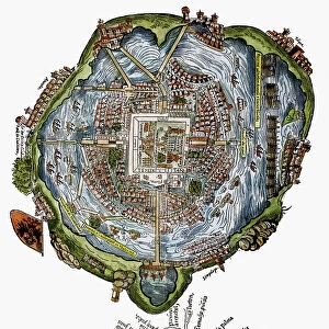
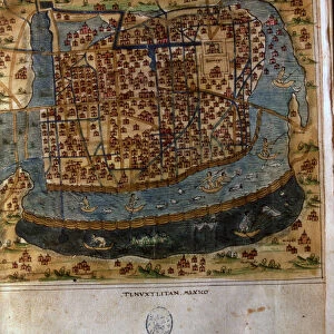
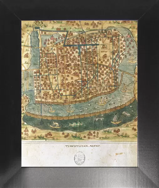
Framed Print : Map of Tenochtitlan. Mexico, 1560. By Alonso de Santa Cruz


![]()
Framed Photos from Mary Evans Picture Library
Map of Tenochtitlan. Mexico, 1560. By Alonso de Santa Cruz
Map of Tenochtitlan. Mexico, 1560. General islario of all the islands in the world. Work of the chronicler and cosmographer Alonso de Santa Cruz (1505-1567). National Library. Madrid. Spain
Mary Evans Picture Library makes available wonderful images created for people to enjoy over the centuries
Media ID 14319317
© Thaliastock / Mary Evans
Alonso Alonzo Aztec Cartography Cruz Geography Latin Mapping Mexican Mexico Tenochtitlan Texcoco
12"x10" Modern Frame
Discover the rich history of Mexico with our exquisite framed print of the Map of Tenochtitlan, created by Alonso de Santa Cruz in 1560. This rare and captivating piece, sourced from Mary Evans Prints Online, offers a glimpse into the past as the general islario of all the islands in the world. Meticulously crafted and beautifully presented in a frame, this framed print is a must-have for history enthusiasts, cartography collectors, or anyone seeking to add a touch of old-world charm to their decor. The intricate details of the map, housed in the National Library of Madrid, Spain, reveal the complexities of the Aztec civilization and their understanding of the world during that era. Bring a piece of history into your home or office with our Museum-quality framed print of the Map of Tenochtitlan by Alonso de Santa Cruz.
10x8 Print in an MDF Wooden Frame with 180 gsm Satin Finish Paper. Glazed using shatter proof thin plexi glass. Frame thickness is 1 inch and depth 0.75 inch. Fluted cardboard backing held with clips. Supplied ready to hang with sawtooth hanger and rubber bumpers. Spot clean with a damp cloth. Packaged foam wrapped in a card.
Contemporary Framed and Mounted Prints - Professionally Made and Ready to Hang
Estimated Image Size (if not cropped) is 25.4cm x 25.4cm (10" x 10")
Estimated Product Size is 25.4cm x 30.5cm (10" x 12")
These are individually made so all sizes are approximate
Artwork printed orientated as per the preview above, with landscape (horizontal) or portrait (vertical) orientation to match the source image.
FEATURES IN THESE COLLECTIONS
> Animals
> Fishes
> Related Images
> Animals
> Mammals
> Cricetidae
> Santa Cruz Mouse
> Europe
> Spain
> Related Images
> Maps and Charts
> Early Maps
EDITORS COMMENTS
This stunning 16th-century map, titled "Map of Tenochtitlan. Mexico. General Islario of All the Islands in the World," is a testament to the remarkable cartographic achievements of the Spanish explorers during the Age of Discovery. Created by the chronicler and cosmographer Alonso de Santa Cruz (1505-1567), this map offers a unique perspective into the geographical knowledge of the New World during this period. The map centers on the Valley of Mexico, with Tenochtitlan, the Aztec capital city, prominently depicted in the center. The map also includes the surrounding areas, including Texcoco and other lake cities. The lake itself, with its intricate network of canals and islands, is depicted with remarkable detail, reflecting the importance of water transportation in the region. The map is part of a larger work known as the "Islario," a comprehensive atlas of the world's islands. The map's title suggests that Santa Cruz intended to include the islands of the Caribbean and the Pacific in his work, reflecting the expanding horizons of Spanish exploration. The map is rich in detail, with various symbols denoting different features, such as fish to represent bodies of water and boats to indicate ports. The map also includes Latin place names, reflecting the European influence on the naming of places in the New World. The intricate detail and accuracy of this map are a reflection of the advanced cartographic techniques of the time, which relied on a combination of observation, local knowledge, and mathematical calculations. The map is a valuable historical document, offering insights into the geographical knowledge of the New World during the 16th century and the early stages of European colonization.
MADE IN THE USA
Safe Shipping with 30 Day Money Back Guarantee
FREE PERSONALISATION*
We are proud to offer a range of customisation features including Personalised Captions, Color Filters and Picture Zoom Tools
SECURE PAYMENTS
We happily accept a wide range of payment options so you can pay for the things you need in the way that is most convenient for you
* Options may vary by product and licensing agreement. Zoomed Pictures can be adjusted in the Cart.