Framed Print > Animals > Insects > Hemiptera > Green Scale
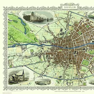
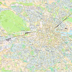
Framed Print : Map of the City of Dublin, 1797


![]()
Framed Photos from Science Photo Library
Map of the City of Dublin, 1797
Map of the City of Dublin, Ireland. Published in 1797, this map includes details of the canals being built at the time. Canal Harbour (lower right) connects across bottom with the Grand Canal (lower left). The Royal Canal (upper right and a branch at upper centre) was a competing canal. Running across centre is the River Liffey. Borders of the citys wards are marked in coloured lines, with a key at lower right, next to the city coat of arms. The scale at lower left is in both English and Irish miles. In 1797, Ireland was ruled by Britain, and this map was published by the geographer to King George III and the Prince of Wales (the future King George IV)
Science Photo Library features Science and Medical images including photos and illustrations
Media ID 6298623
© LIBRARY OF CONGRESS, GEOGRAPHY AND MAP DIVISION/SCIENCE PHOTO LIBRARY
1700s 18th Century Canal Canals Capital City Cartographic Cartography City Coat Of Arms Dock Docks Great Britain Grid Harbour Ireland Irish Maritime Plan Plans Port River Road Roads Scale Shipping Street Streets Survey Trade Transport Transportation Urban Ward Wards Water Way Writing 1797 Districts Dublin English Text Faden George Iii George Iv Georgian Era Grand Canal Lay Out Miles River Liffey Surveyed Water Ways
18"x14" Modern Frame
Introducing the captivating "Map of the City of Dublin, 1797" from our Framed Prints collection at Media Storehouse. This exquisite piece of historical cartography, sourced from Science Photo Library, offers a fascinating glimpse into Dublin's rich past. Published in 1797, this map showcases the city during a pivotal time, as canals were being constructed. The lower right corner of the map highlights the Canal Harbour, a testament to the city's ambitious infrastructure development. Bring this piece of history into your home or office. Our Framed Prints are not just beautiful additions to your space, but also thoughtful and intriguing conversational starters. Order yours today and step back in time to the bustling streets and waterways of 18th-century Dublin.
16x12 Print in an MDF Wooden Frame with 180 gsm Satin Finish Paper. Glazed using shatter proof thin plexiglass. Frame thickness is 1 inch and depth 0.75 inch. Fluted cardboard backing held with clips. Supplied ready to hang with sawtooth hanger and rubber bumpers. Spot clean with a damp cloth. Packaged foam wrapped in a card.
Contemporary Framed and Mounted Prints - Professionally Made and Ready to Hang
Estimated Image Size (if not cropped) is 40.6cm x 35.6cm (16" x 14")
Estimated Product Size is 45.7cm x 35.6cm (18" x 14")
These are individually made so all sizes are approximate
Artwork printed orientated as per the preview above, with landscape (horizontal) orientation to match the source image.
FEATURES IN THESE COLLECTIONS
> Animals
> Insects
> Hemiptera
> Green Scale
> Animals
> Mammals
> Muridae
> House Mouse
> Animals
> Mammals
> Muridae
> Water Mouse
> Arts
> Artists
> P
> George Prince
> Arts
> Landscape paintings
> Waterfall and river artworks
> River artworks
> Asia
> Georgia
> Related Images
> Europe
> Related Images
> Europe
> Republic of Ireland
> Dublin
EDITORS COMMENTS
This print showcases a remarkable piece of history - the Map of the City of Dublin, 1797. Published during Ireland's British rule, this meticulously detailed map provides a fascinating glimpse into the city's layout and development at that time. The canals under construction are prominently featured, with Canal Harbour connecting to the Grand Canal on one side and the Royal Canal on the other. The River Liffey majestically runs through the center, serving as a vital waterway for trade and transportation. The borders of Dublin's wards are clearly marked in vibrant colors, accompanied by a key next to the city coat of arms. A scale at lower left indicates distances in both English and Irish miles, reflecting Ireland's rich cultural heritage. This significant cartographic work was published by none other than the geographer to King George III and Prince of Wales (future King George IV), underscoring its importance. As we delve into this historical treasure trove, we witness an exquisite blend of artistry and geography. Every street, district, dock, road, canal is meticulously surveyed and depicted with utmost precision. This visual masterpiece transports us back to 18th century Dublin - bustling streets filled with maritime activity amidst an evolving urban landscape. With its wealth of information about Dublin's past - from shipping routes to ward divisions - this map serves as an invaluable resource for historians and enthusiasts alike. It stands as a testament to our enduring fascination with cartography while offering glimpses into how cities evolve over time.
MADE IN THE USA
Safe Shipping with 30 Day Money Back Guarantee
FREE PERSONALISATION*
We are proud to offer a range of customisation features including Personalised Captions, Color Filters and Picture Zoom Tools
SECURE PAYMENTS
We happily accept a wide range of payment options so you can pay for the things you need in the way that is most convenient for you
* Options may vary by product and licensing agreement. Zoomed Pictures can be adjusted in the Cart.