
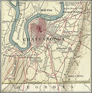
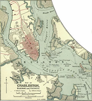
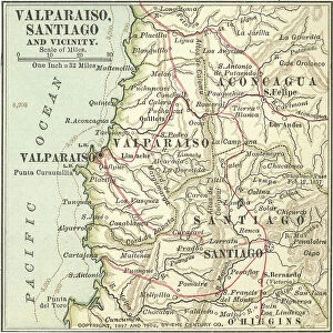
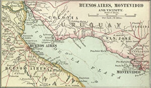
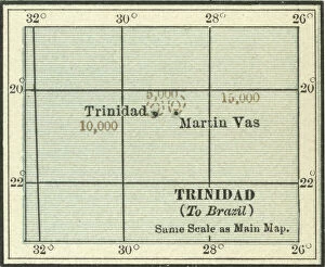
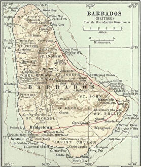
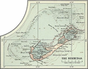
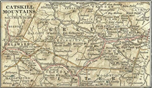
Guidance Collection (page 4)

"Guidance: Illuminating Paths Across Time and Space" Step into the world of guidance, where ancient maps like the Mappa Mundi

Background imageGuidance Collection: Map of Kentucky, c.1900 (engraving)

Map of Kentucky, c.1900 (engraving)
533143 Map of Kentucky, c.1900 (engraving); (add.info.: Map of Kentucky, United States, circa 1902, from the 10th edition of Encyclopaedia Britannica.); Encyclopaedia Britannica/UIG

Background imageGuidance Collection: Map of Pennsylvania with inset map of Philadelphia, c.1900 (engraving)

Map of Pennsylvania with inset map of Philadelphia, c.1900 (engraving)
533115 Map of Pennsylvania with inset map of Philadelphia, c.1900 (engraving); (add.info.: Map of eastern Pennsylvania with inset map of Philadelphia, circa 1902)

Background imageGuidance Collection: Map of New York State, c.1900 (engraving)

Map of New York State, c.1900 (engraving)
533109 Map of New York State, c.1900 (engraving); (add.info.: Map of western New York State, with inset map of Buffalo, Niagara Frontier, and Rochester, circa 1902)

Background imageGuidance Collection: Map of New York State, c.1900 (engraving)

Map of New York State, c.1900 (engraving)
533104 Map of New York State, c.1900 (engraving); (add.info.: Map of southern New York State, United States, insets map of New York City, the Hudson River, and the Catskill Mountains, circa 1902)

Background imageGuidance Collection: Map of North America and Central America, c.1900 (engraving)

Map of North America and Central America, c.1900 (engraving)
533069 Map of North America and Central America, c.1900 (engraving); (add.info.: Map of North America and Central America, circa 1902)

Background imageGuidance Collection: Map of Southern Africa, c.1900 (engraving)

Map of Southern Africa, c.1900 (engraving)
533065 Map of Southern Africa, c.1900 (engraving); (add.info.: Map of colonial southern Africa, with insets of Cape Town, Johannesburg, and Ladysmith, circa 1902)

Background imageGuidance Collection: Map of Cincinnati, c.1900 (engraving)

Map of Cincinnati, c.1900 (engraving)
532743 Map of Cincinnati, c.1900 (engraving); (add.info.: Map of Cincinnati, Ohio, circa 1900, from the 10th edition of Encyclopaedia Britannica.); Encyclopaedia Britannica/UIG

Background imageGuidance Collection: Map of Chattanooga, c.1900 (engraving)

Map of Chattanooga, c.1900 (engraving)
532737 Map of Chattanooga, c.1900 (engraving); (add.info.: Map of Chattanooga, Tennessee, circa 1900, from the 10th edition of Encyclopaedia Britannica.); Encyclopaedia Britannica/UIG

Background imageGuidance Collection: Map of Charleston, c.1900 (engraving)

Map of Charleston, c.1900 (engraving)
532734 Map of Charleston, c.1900 (engraving); (add.info.: Map of Charleston, South Carolina, circa 1900, from the 10th edition of Encyclopaedia Britannica.); Encyclopaedia Britannica/UIG

Background imageGuidance Collection: Map of Valparaiso and Santiago, c.1900 (engraving)

Map of Valparaiso and Santiago, c.1900 (engraving)
533503 Map of Valparaiso and Santiago, c.1900 (engraving); (add.info.: Map of Valparaiso and Santiago, Chile, circa 1902, from the 10th edition of Encyclopaedia Britannica)

Background imageGuidance Collection: Map of Buenos Aires and Montevideo, c.1900 (engraving)

Map of Buenos Aires and Montevideo, c.1900 (engraving)
533500 Map of Buenos Aires and Montevideo, c.1900 (engraving); (add.info.: Inset map of Buenos Aires (Argentina) and Montevideo (Uruguay), circa 1902

Background imageGuidance Collection: Map of Trinidad and Martin Vas, c.1900 (engraving)

Map of Trinidad and Martin Vas, c.1900 (engraving)
533494 Map of Trinidad and Martin Vas, c.1900 (engraving); (add.info.: Map of Trinidad and Martin Vas, circa 1902, from the 10th edition of Encyclopaedia Britannica.); Encyclopaedia Britannica/UIG

Background imageGuidance Collection: Map of Barbados, c.1900 (engraving)

Map of Barbados, c.1900 (engraving)
533469 Map of Barbados, c.1900 (engraving); (add.info.: Map showing the parish boundaries of Barbados, circa 1902, from the 10th edition of Encyclopaedia Britannica.); Encyclopaedia Britannica/UIG

Background imageGuidance Collection: Map of the Bermudas, c.1900 (engraving)

Map of the Bermudas, c.1900 (engraving)
533466 Map of the Bermudas, c.1900 (engraving); (add.info.: Map of the Bermudas, circa 1902, from the 10th edition of Encyclopaedia Britannica.); Encyclopaedia Britannica/UIG

Background imageGuidance Collection: Map of the Catskill Mountains, New York, c.1900 (engraving)

Map of the Catskill Mountains, New York, c.1900 (engraving)
533423 Map of the Catskill Mountains, New York, c.1900 (engraving); (add.info.: Map of Catskill Mountains, New York, circa 1902)

Background imageGuidance Collection: Map of Ladysmith, c.1900 (engraving)

Map of Ladysmith, c.1900 (engraving)
533405 Map of Ladysmith, c.1900 (engraving); (add.info.: Map of Ladysmith, South Africa, circa 1902, from the 10th edition of Encyclopaedia Britannica.); Encyclopaedia Britannica/UIG

Background imageGuidance Collection: Map of Johannesburg, c.1900 (engraving)

Map of Johannesburg, c.1900 (engraving)
533402 Map of Johannesburg, c.1900 (engraving); (add.info.: Map of Johannesburg, South Africa, circa 1902, from the 10th edition of Encyclopaedia Britannica.); Encyclopaedia Britannica/UIG

Background imageGuidance Collection: Map of Saint Helena Island, c.1900 (engraving)

Map of Saint Helena Island, c.1900 (engraving)
533393 Map of Saint Helena Island, c.1900 (engraving); (add.info.: Map of Saint Helena Island, circa 1902, from the 10th edition of Encyclopaedia Britannica.); Encyclopaedia Britannica/UIG

Background imageGuidance Collection: Map of Solomon Islands, c.1900 (engraving)

Map of Solomon Islands, c.1900 (engraving)
533372 Map of Solomon Islands, c.1900 (engraving); (add.info.: Map of Solomon Islands, Bougainville, South Pacific, circa 1902)

Background imageGuidance Collection: Map of islands in the South Pacific, c.1900 (engraving)

Map of islands in the South Pacific, c.1900 (engraving)
533367 Map of islands in the South Pacific, c.1900 (engraving); (add.info.: Map of New Hebrides Islands, Santa Cruz Islands, Loyalty Islands, and New Caledonia, circa 1902)

Background imageGuidance Collection: Map of Guam, c.1900 (engraving)

Map of Guam, c.1900 (engraving)
533357 Map of Guam, c.1900 (engraving); (add.info.: Map of Guam or Guajan Island (U.S.), circa 1902, from the 10th edition of Encyclopaedia Britannica.); Encyclopaedia Britannica/UIG

Background imageGuidance Collection: Map of the north extension of Kurile Islands, c.1900 (engraving)

Map of the north extension of Kurile Islands, c.1900 (engraving)
533332 Map of the north extension of Kurile Islands, c.1900 (engraving); (add.info.: Map of the north extension of Kurile Islands (then part of Japan), circa 1902

Background imageGuidance Collection: Map of Sicily, c.1900 (engraving)

Map of Sicily, c.1900 (engraving)
533317 Map of Sicily, c.1900 (engraving); (add.info.: Map of Sicily, Italy, circa 1902, from the 10th edition of Encyclopaedia Britannica.); Encyclopaedia Britannica/UIG

Background imageGuidance Collection: Map of East India Islands with New Guinea, c.1900 (engraving)

Map of East India Islands with New Guinea, c.1900 (engraving)
533036 Map of East India Islands with New Guinea, c.1900 (engraving); (add.info.: Map of East India Islands, with an inset of New Guinea, circa 1902)

Background imageGuidance Collection: Map of China, c.1900 (engraving)

Map of China, c.1900 (engraving)
533028 Map of China, c.1900 (engraving); (add.info.: Map of China, circa 1902, from the 10th edition of Encyclopaedia Britannica.); Encyclopaedia Britannica/UIG

Background imageGuidance Collection: Map of Arabia with part of Turkey and Oman, c.1900 (engraving)

Map of Arabia with part of Turkey and Oman, c.1900 (engraving)
533009 Map of Arabia with part of Turkey and Oman, c.1900 (engraving); (add.info.: Map of Arabia, Turkey, Oman, Aden, with insets map of Jerusalem and Palestine, circa 1902)

Background imageGuidance Collection: Map of Turkey, c.1900 (engraving)

Map of Turkey, c.1900 (engraving)
533006 Map of Turkey, c.1900 (engraving); (add.info.: Map showing the historical boundaries of Turkey in Asia, circa 1902)

Background imageGuidance Collection: Map of Russia with inset of St. Petersburg, c.1900 (engraving)

Map of Russia with inset of St. Petersburg, c.1900 (engraving)
532995 Map of Russia with inset of St. Petersburg, c.1900 (engraving); (add.info.: Map of Russia, with an inset of St. Petersburg, circa 1902)

Background imageGuidance Collection: Map of Channel Islands, c.1900 (engraving)

Map of Channel Islands, c.1900 (engraving)
533278 Map of Channel Islands, c.1900 (engraving); (add.info.: Map of Channel Islands, United Kingdom, circa 1902, from the 10th edition of Encyclopaedia Britannica.); Encyclopaedia Britannica/UIG

Background imageGuidance Collection: Map of the northwestern part of South America, c.1900 (engraving)

Map of the northwestern part of South America, c.1900 (engraving)
533259 Map of the northwestern part of South America, c.1900 (engraving); (add.info.: Map of northwest South America: Colombia, Venezuela, British Guiana, Ecuador, Peru, and Bolivia, circa 1902)

Background imageGuidance Collection: Map of Mexico, c.1900 (engraving)

Map of Mexico, c.1900 (engraving)
533250 Map of Mexico, c.1900 (engraving); (add.info.: Map of Mexico, circa 1902, from the 10th edition of Encyclopaedia Britannica.); Encyclopaedia Britannica/UIG

Background imageGuidance Collection: Map of Nevada and Utah, c.1900 (engraving)

Map of Nevada and Utah, c.1900 (engraving)
533228 Map of Nevada and Utah, c.1900 (engraving); (add.info.: Map of Nevada and Utah, United States, with an inset map of Salt Lake City, circa 1902)

Background imageGuidance Collection: Map of Colorado, c.1900 (engraving)

Map of Colorado, c.1900 (engraving)
533216 Map of Colorado, c.1900 (engraving); (add.info.: Map of Colorado, United States, circa 1902, from the 10th edition of Encyclopaedia Britannica.); Encyclopaedia Britannica/UIG

Background imageGuidance Collection: Map of Montana, c.1900 (engraving)

Map of Montana, c.1900 (engraving)
533209 Map of Montana, c.1900 (engraving); (add.info.: Map of Montana, United States, circa 1902, from the 10th edition of Encyclopaedia Britannica.); Encyclopaedia Britannica/UIG

Background imageGuidance Collection: Map of Oklahoma and the Indian Territory, c.1900 (engraving)

Map of Oklahoma and the Indian Territory, c.1900 (engraving)
533207 Map of Oklahoma and the Indian Territory, c.1900 (engraving); (add.info.: Map of Oklahoma and the Indian Territory, United States, circa 1902)

Background imageGuidance Collection: Map of San Diego, c.1900 (engraving)

Map of San Diego, c.1900 (engraving)
532854 Map of San Diego, c.1900 (engraving); (add.info.: Map of San Diego, California, circa 1900, from the 10th edition of Encyclopaedia Britannica.); Encyclopaedia Britannica/UIG

Background imageGuidance Collection: Map of Iowa, c.1900 (engraving)

Map of Iowa, c.1900 (engraving)
533195 Map of Iowa, c.1900 (engraving); (add.info.: Map of Iowa, United States, circa 1902, from the 10th edition of Encyclopaedia Britannica.); Encyclopaedia Britannica/UIG

Background imageGuidance Collection: Map of northern Ohio, c.1900 (engraving)

Map of northern Ohio, c.1900 (engraving)
533164 Map of northern Ohio, c.1900 (engraving); (add.info.: Map of the northern part of Ohio, United States, circa 1902, from the 10th edition of Encyclopaedia Britannica)

Background imageGuidance Collection: Map of Alabama, c.1900 (engraving)

Map of Alabama, c.1900 (engraving)
533151 Map of Alabama, c.1900 (engraving); (add.info.: Map of Alabama, United States, circa 1902, from the 10th edition of Encyclopaedia Britannica.); Encyclopaedia Britannica/UIG

Background imageGuidance Collection: Map of Rio De Janeiro, c.1900 (engraving)

Map of Rio De Janeiro, c.1900 (engraving)
532842 Map of Rio De Janeiro, c.1900 (engraving); (add.info.: Map of Rio De Janeiro, circa 1900, from the 10th edition of Encyclopaedia Britannica.); Encyclopaedia Britannica/UIG

Background imageGuidance Collection: Map of Pittsburgh, c.1900 (engraving)

Map of Pittsburgh, c.1900 (engraving)
532828 Map of Pittsburgh, c.1900 (engraving); (add.info.: Map of Pittsburgh, circa 1900, from the 10th edition of Encyclopaedia Britannica.); Encyclopaedia Britannica/UIG

Background imageGuidance Collection: Map of Peking, c.1900 (engraving)

Map of Peking, c.1900 (engraving)
532822 Map of Peking, c.1900 (engraving); (add.info.: Map of Peking (Beijing), China, circa 1900, from the 10th edition of Encyclopaedia Britannica.); Encyclopaedia Britannica/UIG

Background imageGuidance Collection: Map of Omaha, c.1900 (engraving)

Map of Omaha, c.1900 (engraving)
532813 Map of Omaha, c.1900 (engraving); (add.info.: Map of Omaha, Nebraska, circa 1902, from the 10th edition of Encyclopaedia Britannica.); Encyclopaedia Britannica/UIG

Background imageGuidance Collection: Map of Quebec, Canada, c.1900 (engraving)

Map of Quebec, Canada, c.1900 (engraving)
533080 Map of Quebec, Canada, c.1900 (engraving); (add.info.: Map of Quebec, Canada, with insets of Quebec City and Montreal, circa 1902)

Background imageGuidance Collection: Map of Milwaukee, c.1900 (engraving)

Map of Milwaukee, c.1900 (engraving)
532798 Map of Milwaukee, c.1900 (engraving); (add.info.: Map of Milwaukee, Wisconsin, circa 1900, from the 10th edition of Encyclopaedia Britannica.); Encyclopaedia Britannica/UIG

Background imageGuidance Collection: 19th century mariner

19th century mariner
673334 19th century mariner; (add.info.: a nineteenth century Mariner); Universal History Archive/UIG

Background imageGuidance Collection: The three kings or Magi follow the star to Bethlehem in search of Jesus

The three kings or Magi follow the star to Bethlehem in search of Jesus, Illustration from the Dore Bible
3665613 The three kings or Magi follow the star to Bethlehem in search of Jesus, Illustration from the Dore Bible, 1866 (engraving) by Dore

Background imageGuidance Collection: Map of Japan and Korea, c.1900 (engraving)

Map of Japan and Korea, c.1900 (engraving)
533031 Map of Japan and Korea, c.1900 (engraving); (add.info.: Map of Japan and Korea, with insets of Kurile Islands, Liu-Kiu Islands and Formosa, circa 1902)


For sale as Licensed Images

Choose your image, Select your licence and Download the media

"Guidance: Illuminating Paths Across Time and Space" Step into the world of guidance, where ancient maps like the Mappa Mundi, inked with vibrant colors on delicate parchment, reveal the journeys of explorers in 1265 London. Feel the guiding light emanating from Sturgeon Bay Lighthouse in Door County, Wisconsin. Its beacon has guided countless sailors through treacherous waters to safety. In Pyongyang, Democratic People's Republic of Korea (DPRK), a painting depicting Great Leaders Kim Jong Il and Kim Il Sung stands as a symbol of unwavering guidance for their nation amidst turbulent times. At Fanad Head Lighthouse, witness how its steadfast presence guides ships along Ireland's rugged coastline, offering solace in stormy seas. Gaze upon Christ the Redeemer overlooking Rio de Janeiro from atop Sugar Loaf mountain. His outstretched arms serve as a constant reminder that they are be found even in towering heights. Discover unexpected guidance through "The Vegetabull" poster—a whimsical depiction reminding us to embrace nature's bounty and nourish our souls with its colorful offerings. As mid-summer sunrise bathes The Mull of Galloway Lighthouse in golden hues, let it remind you that each dawn brings new possibilities and fresh opportunities for personal growth. Travel across continents to Cape Neddick (The Nubble) Lighthouse in Maine. Witness how this stoic structure has provided unwavering guidance to mariners navigating New England's rocky shores since time immemorial. Enter "The New Jerusalem, " an enchanting vision crafted around 1900. This utopian cityscape serves as a testament to humanity's eternal quest for spiritual enlightenment and divine guidance. Underneath moonlit skies at Whitefish Point Lighthouse, allow yourself to be captivated by its ethereal glow. It stands as a guardian guiding lost souls home amidst Lake Superior’s vast expanse.