Home > Europe > United Kingdom > England > London > Boroughs > Greenwich
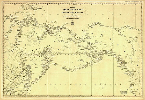
Karta Ledovitago mori?a? i Vostochnago okeana, 1844. Creator: Unknown
![]()

Wall Art and Photo Gifts from Heritage Images
Karta Ledovitago mori?a? i Vostochnago okeana, 1844. Creator: Unknown
Karta Ledovitago mori?a? i Vostochnago okeana, 1844. Depths shown by soundings in coastal waters. Also covers Russian Far East and Alaska. Greenwich, Paris, and Petersburg meridians; Greenwich degrees numbered westward to 240°. Includes Hydrographic Department insigne. LC copy rubber-stamped, annotated on cloth backing, fold-lined
Heritage Images features heritage image collections
Media ID 35129439
© Heritage Art/Heritage Images
1840s Alaska United States Of America Arctic Ocean Cartographic Cartography Cyrillic Depth Map Making Mapmaking Ocean Hydrography Meeting Of Frontiers Meridian
FEATURES IN THESE COLLECTIONS
> Animals
> Mammals
> Muridae
> Water Mouse
> Arts
> Artists
> O
> Oceanic Oceanic
> Europe
> France
> Paris
> Maps
> Europe
> Russia
> Related Images
> Europe
> United Kingdom
> England
> London
> Boroughs
> Greenwich
> Maps and Charts
> Early Maps
> Maps and Charts
> Related Images
EDITORS COMMENTS
This 19th century map print, titled "Karta Ledovitago mori?a? i Vostochnago okeana" or "Chart of the Frozen Sea and the Eastern Ocean," dates back to 1844. The creator of this masterpiece remains unknown, but its intricate details and meticulous hydrographic data reveal the advanced cartographic techniques of the time. The map covers a vast expanse of water, extending from the Arctic Ocean in the north to the Russian Far East and Alaska in the west. The map's depths are indicated by soundings in coastal waters, providing valuable information for mariners and explorers of the era. The Greenwich, Paris, and Petersburg meridians are marked, with Greenwich degrees numbered westward to 240°. The Hydrographic Department insigne is prominently displayed, attesting to the map's official status and scientific accuracy. This map is a testament to the meeting of frontiers and the spirit of exploration and discovery that characterized the 19th century. The intricate lettering, colorful hues, and precise depiction of geographical features showcase the art and science of cartography during this period. The Library of Congress holds this historic treasure, with its cloth backing bearing a rubber-stamp and annotations, adding to its unique heritage value. The map's title, written in Cyrillic script, hints at the Russian origins of the map, reflecting the country's rich maritime history and its significant role in the exploration of the Arctic and the Eastern Ocean. This map is not only a fascinating piece of cartographic history but also a reminder of the scientific and exploratory achievements of the 19th century.
MADE IN THE USA
Safe Shipping with 30 Day Money Back Guarantee
FREE PERSONALISATION*
We are proud to offer a range of customisation features including Personalised Captions, Color Filters and Picture Zoom Tools
SECURE PAYMENTS
We happily accept a wide range of payment options so you can pay for the things you need in the way that is most convenient for you
* Options may vary by product and licensing agreement. Zoomed Pictures can be adjusted in the Cart.

