Jigsaw Puzzle > Arts > Photorealistic artworks > Detailed art pieces > Masterful detailing in art
Jigsaw Puzzle : General Map of Mogilev Province: Showing Postal and Major Roads, Stations and... 1821. Creators: Vasilii Petrovich Piadyshev, Faleleef


![]()
Jigsaw Puzzles from Heritage Images
General Map of Mogilev Province: Showing Postal and Major Roads, Stations and... 1821. Creators: Vasilii Petrovich Piadyshev, Faleleef
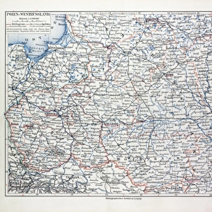
General Map of Mogilev Province: Showing Postal and Major Roads, Stations and the Distance in Versts between Them, 1821. This 1821 map of Mogilev Provinceis from a larger work, Geograficheskii atlas Rossiiskoi imperii, tsarstva Pol'skogo i velikogo kniazhestva Finliandskogo(Geographical atlas of the Russian Empire, the Kingdom of Poland, and the Grand Duchy of Finland), containing 60 maps of the Russian Empire. Compiled and engraved by Colonel V.P. Piadyshev, it reflects the detailed mapping carried out by Russian military cartographers in the first quarter of the 19th century. The map shows population centers (six gradations by size), postal stations, roads (four types), provincial and district borders, monasteries, factories, and taverns. Distances are shown in versts, a Russian measure, now no longer used, equal to 1.07 kilometers.Legends and place-names are in Russian and Polish
Heritage Images features heritage image collections
Media ID 35127645
© Heritage Art/Heritage Images
1820s Atlas Belarus Border Borders Cartographic Cartography Communication Cyrillic Factories Faleleef Legend Map Making Mapmaking Monasteries Monastery Piadyshev Vasilii Petrovich Population Public House Roads Russian Empire Russian Federation Tavern Thoroughfare Vasilii Petrovich Piadyshev Vp Piadyshev Meeting Of Frontiers Postal Service
Jigsaw Puzzle (520 Pieces)
Discover the historical charm of the past with our exquisite jigsaw puzzle from Media Storehouse. This intricately detailed puzzle features a captivating General Map of Mogilev Province from 1821, created by renowned cartographers Vasilii Petrovich Piadyshev and Faleleef. Delve into the rich history of this region as you piece together the image, revealing postal and major roads, stations, and distances in versts between them. A perfect addition to any home or office, this puzzle is not only a fun and engaging activity but also an educational experience, transporting you back in time to the early 19th century. Immerse yourself in the intricacies of the map and the beauty of the historical detail. Puzzle enthusiasts, historians, and anyone with a passion for the past will appreciate the depth and detail of this captivating jigsaw puzzle.
Made in the USA, 520-piece puzzles measure 16" x 20" (40.6 x 50.8 cm). Every puzzle is meticulously printed on glossy photo paper, which has a strong 1.33 mm thickness. Delivered in a black storage cardboard box, these puzzles are both stylish and practical. (Note: puzzles contain small parts and are not suitable for children under 3 years of age.)
Jigsaw Puzzles are an ideal gift for any occasion
Estimated Product Size is 50.8cm x 40.5cm (20" x 15.9")
These are individually made so all sizes are approximate
Artwork printed orientated as per the preview above, with landscape (horizontal) or portrait (vertical) orientation to match the source image.
FEATURES IN THESE COLLECTIONS
> Animals
> Mammals
> Muridae
> House Mouse
> Arts
> Photorealistic artworks
> Detailed art pieces
> Masterful detailing in art
> Europe
> Belarus
> Related Images
> Europe
> Finland
> Related Images
> Europe
> Poland
> Related Images
EDITORS COMMENTS
This historic map print, titled "General Map of Mogilev Province: Showing Postal and Major Roads, Stations and the Distance in Versts between Them," dates back to 1821. It is an extract from the larger work, "Geograficheskii atlas Rossiiskoi imperii, tsarstva Pol'skogo i velikogo kniazhestva Finliandskogo" (Geographical atlas of the Russian Empire, the Kingdom of Poland, and the Grand Duchy of Finland), which contained 60 maps of the Russian Empire. The map was compiled and engraved by Colonel Vasilii Petrovich Piadyshev and Faleleef. The map provides an intriguing glimpse into the cartographic knowledge of the Russian Empire during the early 19th century. It meticulously depicts the Mogilev Province with six gradations of population centers, postal stations, roads of four types, provincial and district borders, monasteries, factories, and taverns. The distances between these features are indicated in versts, a Russian measure equal to 1.07 kilometers. The map's detailed representation is a testament to the extensive mapping efforts carried out by Russian military cartographers during this period. The legends and place-names are in both Russian and Polish, reflecting the multicultural nature of the region. This map offers valuable historical insights into the geography, infrastructure, and administrative divisions of Mogilev Province during the Russian Empire. As a historical artifact, this map print is an essential resource for researchers, historians, and anyone interested in the history of cartography and the Russian Empire.
MADE IN THE USA
Safe Shipping with 30 Day Money Back Guarantee
FREE PERSONALISATION*
We are proud to offer a range of customisation features including Personalised Captions, Color Filters and Picture Zoom Tools
SECURE PAYMENTS
We happily accept a wide range of payment options so you can pay for the things you need in the way that is most convenient for you
* Options may vary by product and licensing agreement. Zoomed Pictures can be adjusted in the Cart.