Jigsaw Puzzle > Arts > Artists > M > Gerardus Mercator
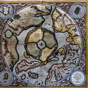
Jigsaw Puzzle : Theatrum Orbis Terrarium, 1592. Creator: Unknown


![]()
Jigsaw Puzzles from Heritage Images
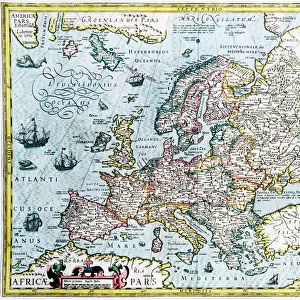
Theatrum Orbis Terrarium, 1592. Creator: Unknown
Theatrum Orbis Terrarium, 1592. Called the first modern atlas, adapted from Mercator's world map; large coloured atlas with Ptolemy's Geographia, 1592; continents, including America (Novis Orbis), Arctic, Antarctic and Asia
Heritage Images features heritage image collections
Media ID 36370103
© Heritage Art/Heritage Images
Abraham Ortelius Antarctic Cartography Claudius Of Ptolemaeus Claudius Ptolemaeus Claudius Ptolemy Latin Map Making Mapmaking New World North America Ptolemy Walters Art Museum Gerardus Mercator Hindoostan Ortelius Abraham
Jigsaw Puzzle (520 Pieces)
Discover the wonders of the ancient world with our Jigsaw Puzzle collection from Media Storehouse. This captivating puzzle showcases Theatrum Orbis Terrarum, a masterpiece from 1592, often referred to as the first modern atlas. Adapted from Mercator's world map, this intricately detailed puzzle includes Ptolemy's Geographia and vividly colored representations of continents, including the newly discovered America. Unravel the mysteries of this historical puzzle and travel back in time as you piece together the fascinating map that shaped the world as we know it today.
Made in the USA, 520-piece puzzles measure 16" x 20" (40.6 x 50.8 cm). Every puzzle is meticulously printed on glossy photo paper, which has a strong 1.33 mm thickness. Delivered in a black storage cardboard box, these puzzles are both stylish and practical. (Note: puzzles contain small parts and are not suitable for children under 3 years of age.)
Jigsaw Puzzles are an ideal gift for any occasion
Estimated Product Size is 50.8cm x 40.5cm (20" x 15.9")
These are individually made so all sizes are approximate
Artwork printed orientated as per the preview above, with landscape (horizontal) or portrait (vertical) orientation to match the source image.
FEATURES IN THESE COLLECTIONS
> Africa
> South Africa
> Maps
> Africa
> South Africa
> Related Images
> Arts
> Artists
> M
> Gerardus Mercator
> Arts
> Artists
> O
> Abraham Ortelius
> Asia
> India
> Related Images
> Europe
> Netherlands
> Maps
> Europe
> Netherlands
> Posters
> Europe
> Netherlands
> Related Images
> Maps and Charts
> Abraham Ortelius
> Maps and Charts
> Gerardus Mercator's Cartographic
EDITORS COMMENTS
This image showcases Theatrum Orbis Terrarum, the first modern atlas, created in 1592. The atlas, whose creator remains unknown, was a groundbreaking achievement in cartography, adapting and expanding upon Gerardus Mercator's world map. The large, colorful atlas includes Ptolemy's Geographia, making it a significant milestone in the history of mapmaking. The intricately detailed map showcases the continents of Europe, Asia, Africa, America (Novis Orbis), Arctic, and Antarctic, with vivid colors and precise lettering. The map's title, "Theatrum Orbis Terrarum," meaning "Theatre of the World," reflects the sense of discovery and exploration that characterized the 16th century. Notable features of this map include the accurate representation of India, Hindoostan, and Russia, which were previously underrepresented or misrepresented in earlier maps. The map also includes the newly discovered lands of the Americas, with North and South America depicted in detail. The map's text is written in Latin, reflecting the scholarly and intellectual context of the time. The mapmaking tradition of the Low Countries, particularly in the Netherlands and Belgium, is evident in the high-quality production and attention to detail. The Theatrum Orbis Terrarum represents a crucial moment in the history of cartography, as it marked a significant step forward in the accuracy and comprehensiveness of world maps. This rare and valuable artifact is a testament to the curiosity and exploratory spirit of the 16th century, and a reminder of the rich heritage of mapmaking that continues to influence our understanding of the world today.
MADE IN THE USA
Safe Shipping with 30 Day Money Back Guarantee
FREE PERSONALISATION*
We are proud to offer a range of customisation features including Personalised Captions, Color Filters and Picture Zoom Tools
SECURE PAYMENTS
We happily accept a wide range of payment options so you can pay for the things you need in the way that is most convenient for you
* Options may vary by product and licensing agreement. Zoomed Pictures can be adjusted in the Cart.