Jigsaw Puzzle > Oceania > New Zealand > Maps
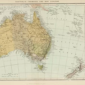
Jigsaw Puzzle : Map / Australia / Nz 1862


![]()
Jigsaw Puzzles from Mary Evans Picture Library
Map / Australia / Nz 1862
Map of Australia and New Zealand
Mary Evans Picture Library makes available wonderful images created for people to enjoy over the centuries
Media ID 608857
© Mary Evans Picture Library 2015 - https://copyrighthub.org/s0/hub1/creation/maryevans/MaryEvansPictureID/10114191
Jigsaw Puzzle (520 Pieces)
Discover the rich history of Australia and New Zealand with our captivating jigsaw puzzles from Media Storehouse, featuring an intricately detailed map depicting the regions as they appeared in 1862. This vintage map, sourced from Mary Evans Prints Online, offers a unique glimpse into the past, making it an excellent addition to any home or office. Engage your mind and challenge your problem-solving skills as you piece together the intricate puzzle borders and explore the historical landmarks and geographical features of this fascinating region. Travel back in time and ignite your curiosity with the Media Storehouse Map / Australia / NZ 1862 jigsaw puzzle.
Made in the USA, 520-piece puzzles measure 16" x 20" (40.6 x 50.8 cm). Every puzzle is meticulously printed on glossy photo paper, which has a strong 1.33 mm thickness. Delivered in a black storage cardboard box, these puzzles are both stylish and practical. (Note: puzzles contain small parts and are not suitable for children under 3 years of age.)
Jigsaw Puzzles are an ideal gift for any occasion
Estimated Product Size is 50.8cm x 40.5cm (20" x 15.9")
These are individually made so all sizes are approximate
Artwork printed orientated as per the preview above, with landscape (horizontal) or portrait (vertical) orientation to match the source image.
FEATURES IN THESE COLLECTIONS
> Maps and Charts
> Early Maps
> Maps and Charts
> Related Images
> Oceania
> Australia
> Related Images
> Oceania
> New Zealand
> Maps
> Oceania
> New Zealand
> Related Images
EDITORS COMMENTS
This stunning print captures a piece of history with the Map of Australia and New Zealand from 1862. The intricate details on this map showcase the geographical features, cities, and territories of both countries during that time period. It is fascinating to see how these lands were divided and labeled over a century ago.
The Map of Australia and New Zealand serves as a reminder of the rich history and exploration that shaped these nations. From the vast deserts of Australia to the lush landscapes of New Zealand, this map provides a glimpse into the diverse environments that make up these regions.
As we study this historical map, we can appreciate the advancements in cartography and navigation that allowed for such detailed representations to be created. It is truly a work of art that tells a story of discovery and colonization in the southern hemisphere.
Whether you have an interest in geography, history, or simply enjoy admiring antique maps, this print is sure to captivate your imagination. Display it proudly in your home or office as a conversation piece that sparks curiosity about the past.
MADE IN THE USA
Safe Shipping with 30 Day Money Back Guarantee
FREE PERSONALISATION*
We are proud to offer a range of customisation features including Personalised Captions, Color Filters and Picture Zoom Tools
SECURE PAYMENTS
We happily accept a wide range of payment options so you can pay for the things you need in the way that is most convenient for you
* Options may vary by product and licensing agreement. Zoomed Pictures can be adjusted in the Cart.