Poster Print > Oceania > New Zealand > Maps
Poster Print : Map / Australia / Nz 1862


![]()
Poster Prints from Mary Evans Picture Library
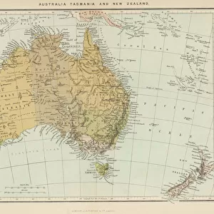
Map / Australia / Nz 1862
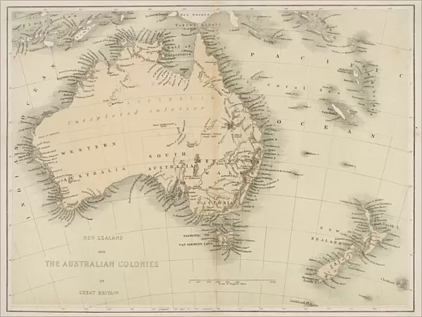
Map of Australia and New Zealand
Mary Evans Picture Library makes available wonderful images created for people to enjoy over the centuries
Media ID 608857
© Mary Evans Picture Library 2015 - https://copyrighthub.org/s0/hub1/creation/maryevans/MaryEvansPictureID/10114191
18x24 inch Poster Print
Discover the rich history of Oceania with our stunning Map / Australia / NZ 1862 poster print from the Media Storehouse collection, exclusively sourced from Mary Evans Prints Online. This captivating vintage map showcases the intricate details of Australia and New Zealand as they appeared in 1862. Bring a piece of history into your home or office with this beautiful, high-quality poster print. Perfect for history enthusiasts, world travelers, or anyone who appreciates the beauty of historical cartography. Add this unique and intriguing piece to your collection today.
Poster prints are budget friendly enlarged prints in standard poster paper sizes. Printed on 150 gsm Matte Paper for a natural feel and supplied rolled in a tube. Great for framing and should last many years. To clean wipe with a microfiber, non-abrasive cloth or napkin. Our Archival Quality Photo Prints and Fine Art Paper Prints are printed on higher quality paper and the choice of which largely depends on your budget.
Poster prints are budget friendly enlarged prints in standard poster paper sizes (A0, A1, A2, A3 etc). Whilst poster paper is sometimes thinner and less durable than our other paper types, they are still ok for framing and should last many years. Our Archival Quality Photo Prints and Fine Art Paper Prints are printed on higher quality paper and the choice of which largely depends on your budget.
Estimated Product Size is 61.6cm x 46.3cm (24.3" x 18.2")
These are individually made so all sizes are approximate
Artwork printed orientated as per the preview above, with landscape (horizontal) orientation to match the source image.
FEATURES IN THESE COLLECTIONS
> Maps and Charts
> Early Maps
> Maps and Charts
> Related Images
> Oceania
> Australia
> Related Images
> Oceania
> New Zealand
> Maps
> Oceania
> New Zealand
> Related Images
EDITORS COMMENTS
This stunning print captures a piece of history with the Map of Australia and New Zealand from 1862. The intricate details on this map showcase the geographical features, cities, and territories of both countries during that time period. It is fascinating to see how these lands were divided and labeled over a century ago.
The Map of Australia and New Zealand serves as a reminder of the rich history and exploration that shaped these nations. From the vast deserts of Australia to the lush landscapes of New Zealand, this map provides a glimpse into the diverse environments that make up these regions.
As we study this historical map, we can appreciate the advancements in cartography and navigation that allowed for such detailed representations to be created. It is truly a work of art that tells a story of discovery and colonization in the southern hemisphere.
Whether you have an interest in geography, history, or simply enjoy admiring antique maps, this print is sure to captivate your imagination. Display it proudly in your home or office as a conversation piece that sparks curiosity about the past.
MADE IN THE USA
Safe Shipping with 30 Day Money Back Guarantee
FREE PERSONALISATION*
We are proud to offer a range of customisation features including Personalised Captions, Color Filters and Picture Zoom Tools
SECURE PAYMENTS
We happily accept a wide range of payment options so you can pay for the things you need in the way that is most convenient for you
* Options may vary by product and licensing agreement. Zoomed Pictures can be adjusted in the Cart.