Photographic Print > Oceania > New Zealand > Maps
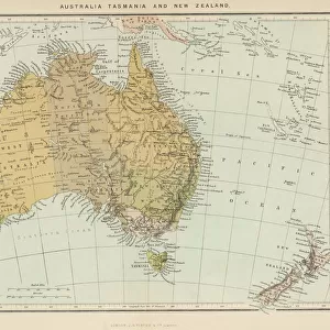
Photographic Print : Map / Australia / Nz 1862


![]()
Photo Prints from Mary Evans Picture Library
Map / Australia / Nz 1862
Map of Australia and New Zealand
Mary Evans Picture Library makes available wonderful images created for people to enjoy over the centuries
Media ID 608857
© Mary Evans Picture Library 2015 - https://copyrighthub.org/s0/hub1/creation/maryevans/MaryEvansPictureID/10114191
10"x8" Photo Print
Discover the rich history of Oceania with our exquisite selection of vintage maps from Media Storehouse. This captivating print, sourced from Mary Evans Prints Online, showcases a detailed map of Australia and New Zealand from the year 1862. Travel back in time as you explore the intricate borders, territories, and annotations that reveal the geopolitical landscape of the region during this fascinating era. Ideal for history enthusiasts, educators, and collectors, our high-quality photographic prints are perfect for adorning walls in your home or office, and make for unique and thoughtful gifts. Experience the past in stunning detail with Media Storehouse.
Photo prints are produced on Kodak professional photo paper resulting in timeless and breath-taking prints which are also ideal for framing. The colors produced are rich and vivid, with accurate blacks and pristine whites, resulting in prints that are truly timeless and magnificent. Whether you're looking to display your prints in your home, office, or gallery, our range of photographic prints are sure to impress. Dimensions refers to the size of the paper in inches.
Our Photo Prints are in a large range of sizes and are printed on Archival Quality Paper for excellent colour reproduction and longevity. They are ideal for framing (our Framed Prints use these) at a reasonable cost. Alternatives include cheaper Poster Prints and higher quality Fine Art Paper, the choice of which is largely dependant on your budget.
Estimated Product Size is 25.4cm x 20.3cm (10" x 8")
These are individually made so all sizes are approximate
Artwork printed orientated as per the preview above, with landscape (horizontal) or portrait (vertical) orientation to match the source image.
FEATURES IN THESE COLLECTIONS
> Maps and Charts
> Early Maps
> Maps and Charts
> Related Images
> Oceania
> Australia
> Related Images
> Oceania
> New Zealand
> Maps
> Oceania
> New Zealand
> Related Images
EDITORS COMMENTS
This stunning print captures a piece of history with the Map of Australia and New Zealand from 1862. The intricate details on this map showcase the geographical features, cities, and territories of both countries during that time period. It is fascinating to see how these lands were divided and labeled over a century ago.
The Map of Australia and New Zealand serves as a reminder of the rich history and exploration that shaped these nations. From the vast deserts of Australia to the lush landscapes of New Zealand, this map provides a glimpse into the diverse environments that make up these regions.
As we study this historical map, we can appreciate the advancements in cartography and navigation that allowed for such detailed representations to be created. It is truly a work of art that tells a story of discovery and colonization in the southern hemisphere.
Whether you have an interest in geography, history, or simply enjoy admiring antique maps, this print is sure to captivate your imagination. Display it proudly in your home or office as a conversation piece that sparks curiosity about the past.
MADE IN THE USA
Safe Shipping with 30 Day Money Back Guarantee
FREE PERSONALISATION*
We are proud to offer a range of customisation features including Personalised Captions, Color Filters and Picture Zoom Tools
SECURE PAYMENTS
We happily accept a wide range of payment options so you can pay for the things you need in the way that is most convenient for you
* Options may vary by product and licensing agreement. Zoomed Pictures can be adjusted in the Cart.