Jigsaw Puzzle > Europe > France > Paris > Maps
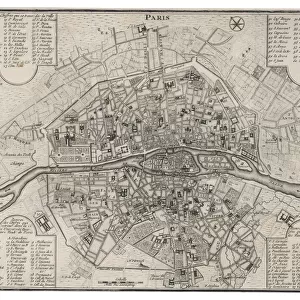
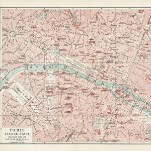
Jigsaw Puzzle : Map of Paris in 1908 with geographic and demographical data


![]()
Jigsaw Puzzles from Mary Evans Picture Library
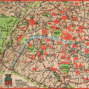
Map of Paris in 1908 with geographic and demographical data
Map of Paris in 1908 with geographic and demographic data featured (as well as the location of all of the major sites in the city centre). Date: 1908
Mary Evans Picture Library makes available wonderful images created for people to enjoy over the centuries
Media ID 14251044
© Mary Evans / Grenville Collins Postcard Collection
Data Demographic Geographic Locations Major Parisian Seine Sites Tourist
Jigsaw Puzzle (1014 Pieces)
Discover the rich history of Paris in 1908 with our intricately detailed jigsaw puzzle from Media Storehouse. This captivating puzzle presents a vintage map of Paris, featuring geographic and demographic data from Mary Evans Prints Online. Explore the location of major sites in the city center, adding a touch of history and education to your puzzle-solving experience. Immerse yourself in the charm of Parisian culture as you piece together this beautiful and informative puzzle.
Made in the USA, 1014-piece puzzles measure 20" x 30" (50.8 x 76.2 cm). Every puzzle is meticulously printed on glossy photo paper, which has a strong 1.33 mm thickness. Delivered in a black storage cardboard box, these puzzles are both stylish and practical. (Note: puzzles contain small parts and are not suitable for children under 3 years of age.)
Jigsaw Puzzles are an ideal gift for any occasion
Estimated Product Size is 76cm x 50.8cm (29.9" x 20")
These are individually made so all sizes are approximate
Artwork printed orientated as per the preview above, with landscape (horizontal) orientation to match the source image.
FEATURES IN THESE COLLECTIONS
> Arts
> Landscape paintings
> Waterfall and river artworks
> River artworks
> Europe
> France
> Paris
> Maps
> Europe
> France
> Paris
> Related Images
> Europe
> France
> Paris
> River Seine
> Maps and Charts
> Related Images
EDITORS COMMENTS
Step back in time and explore the vibrant and historic city of Paris as it appeared in 1908, with this intricately detailed map. The map provides an accurate representation of the city's geography during this period, including the winding paths of the Seine River and the layout of the city's many arrondissements. But this map is more than just a geographic representation, it also offers valuable demographic data, providing insights into the population density and distribution across the city. The map highlights the location of Paris's major sites, many of which remain popular tourist destinations today. The iconic Notre-Dame Cathedral, the Louvre Museum, and the Eiffel Tower are all clearly marked, inviting the viewer to imagine the bustling crowds that would have gathered around these landmarks over a century ago. The map also reveals the city's rich history and cultural heritage, with the location of various churches, markets, and historic monuments. The labyrinthine streets of the Latin Quarter, the elegant boulevards of the Marais, and the bohemian Montmartre district are all accounted for, offering a glimpse into the diverse and dynamic neighborhoods that make up this iconic city. As you explore this map of Paris in 1908, you'll gain a deeper appreciation for the city's rich history and the way it has evolved over time. From its iconic landmarks to its bustling streets and vibrant neighborhoods, this map offers a unique window into the past, inviting you to imagine the sights, sounds, and experiences of Paris a century ago.
MADE IN THE USA
Safe Shipping with 30 Day Money Back Guarantee
FREE PERSONALISATION*
We are proud to offer a range of customisation features including Personalised Captions, Color Filters and Picture Zoom Tools
SECURE PAYMENTS
We happily accept a wide range of payment options so you can pay for the things you need in the way that is most convenient for you
* Options may vary by product and licensing agreement. Zoomed Pictures can be adjusted in the Cart.