Metal Print > Europe > France > Paris > Maps
Metal Print : Map of Paris in 1908 with geographic and demographical data


![]()
Metal Prints from Mary Evans Picture Library
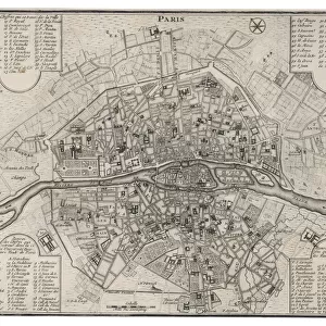
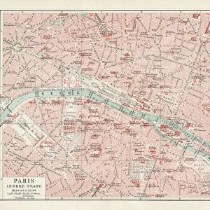
Map of Paris in 1908 with geographic and demographical data
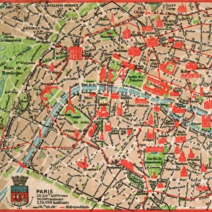
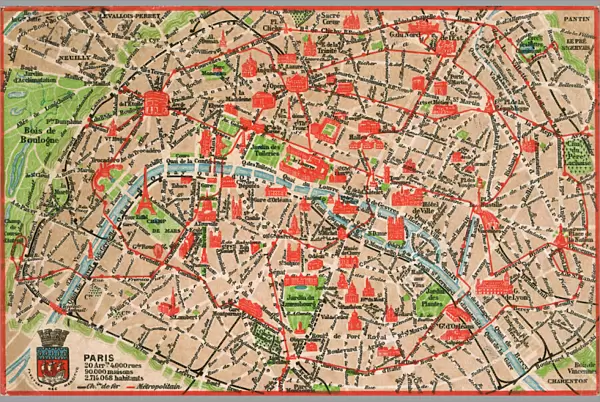
Map of Paris in 1908 with geographic and demographic data featured (as well as the location of all of the major sites in the city centre). Date: 1908
Mary Evans Picture Library makes available wonderful images created for people to enjoy over the centuries
Media ID 14251044
© Mary Evans / Grenville Collins Postcard Collection
Data Demographic Geographic Locations Major Parisian Seine Sites Tourist
16"x24" (61x41cm) Metal Print
Discover the enchanting allure of Paris in 1908 with our exquisite Media Storehouse Metal Print. This unique and captivating piece showcases an intricately detailed Map of Paris, complete with geographic and demographic data sourced from Mary Evans Prints Online. Travel back in time as you explore the location of major sites in the city centre, all beautifully rendered in vivid colors and sharp detail on high-quality metal. Elevate your home or office decor with this timeless and thought-provoking piece, a perfect conversation starter for history and travel enthusiasts alike.
Made with durable metal and luxurious printing techniques, our metal photo prints go beyond traditional canvases, adding a cool, modern touch to your space. Wall mount on back. Eco-friendly 100% post-consumer recycled ChromaLuxe aluminum surface. The thickness of the print is 0.045". Featuring a Scratch-resistant surface and Rounded corners. Backing hangers are attached to the back of the print and float the print 1/2-inch off the wall when hung, the choice of hanger may vary depending on size and International orders will come with Float Mount hangers only. Finished with a brilliant white high gloss surface for unsurpassed detail and vibrance. Printed using Dye-Sublimation and for best care we recommend a non-ammonia glass cleaner, water, or isopropyl (rubbing) alcohol to prevent harming the print surface. We recommend using a clean, lint-free cloth to wipe off the print. The ultra-hard surface is scratch-resistant, waterproof and weatherproof. Avoid direct sunlight exposure.
Made with durable metal and luxurious printing techniques, metal prints bring images to life and add a modern touch to any space
Estimated Product Size is 61.5cm x 41.2cm (24.2" x 16.2")
These are individually made so all sizes are approximate
Artwork printed orientated as per the preview above, with landscape (horizontal) orientation to match the source image.
FEATURES IN THESE COLLECTIONS
> Arts
> Landscape paintings
> Waterfall and river artworks
> River artworks
> Europe
> France
> Paris
> Maps
> Europe
> France
> Paris
> Related Images
> Europe
> France
> Paris
> River Seine
> Maps and Charts
> Related Images
EDITORS COMMENTS
Step back in time and explore the vibrant and historic city of Paris as it appeared in 1908, with this intricately detailed map. The map provides an accurate representation of the city's geography during this period, including the winding paths of the Seine River and the layout of the city's many arrondissements. But this map is more than just a geographic representation, it also offers valuable demographic data, providing insights into the population density and distribution across the city. The map highlights the location of Paris's major sites, many of which remain popular tourist destinations today. The iconic Notre-Dame Cathedral, the Louvre Museum, and the Eiffel Tower are all clearly marked, inviting the viewer to imagine the bustling crowds that would have gathered around these landmarks over a century ago. The map also reveals the city's rich history and cultural heritage, with the location of various churches, markets, and historic monuments. The labyrinthine streets of the Latin Quarter, the elegant boulevards of the Marais, and the bohemian Montmartre district are all accounted for, offering a glimpse into the diverse and dynamic neighborhoods that make up this iconic city. As you explore this map of Paris in 1908, you'll gain a deeper appreciation for the city's rich history and the way it has evolved over time. From its iconic landmarks to its bustling streets and vibrant neighborhoods, this map offers a unique window into the past, inviting you to imagine the sights, sounds, and experiences of Paris a century ago.
MADE IN THE USA
Safe Shipping with 30 Day Money Back Guarantee
FREE PERSONALISATION*
We are proud to offer a range of customisation features including Personalised Captions, Color Filters and Picture Zoom Tools
SECURE PAYMENTS
We happily accept a wide range of payment options so you can pay for the things you need in the way that is most convenient for you
* Options may vary by product and licensing agreement. Zoomed Pictures can be adjusted in the Cart.