Jigsaw Puzzle > Europe > United Kingdom > Wales > Maps
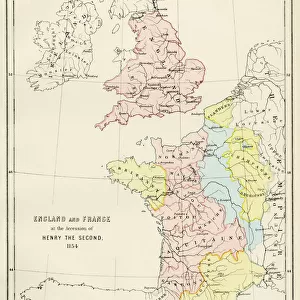
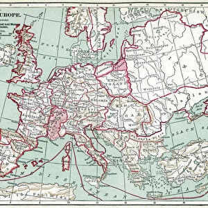
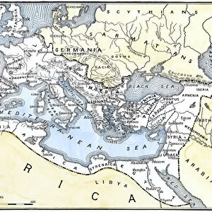
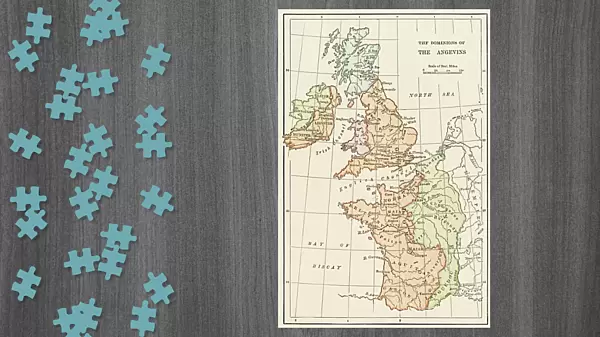
Jigsaw Puzzle : Angevin kings holdings in France and Britain


![]()
Jigsaw Puzzles from North Wind
Angevin kings holdings in France and Britain
British Isles and France under the Angevins, 1100s-1400s.
Color lithograph reproduction of a 19th-century illustration
North Wind Picture Archives brings history to life with stock images and hand-colored illustrations
Media ID 5879176
© North Wind Picture Archives
100 Years War 1100s 1200s 12th Century 1300s 13th Century 1400s 14th Century 15th Century British Eire England English Europe Family France French Great Britain Ireland Medieval Middle Ages Scot Land Wales Angevin Anjou Plantagenet
Jigsaw Puzzle (1014 Pieces)
Discover the rich history of the Angevin Kingdoms with our captivating jigsaw puzzle from Media Storehouse. This intriguing puzzle features a stunning color lithograph reproduction of an 1800s illustration from North Wind Picture Archives, depicting the holdings of the Angevin kings in France and Britain during the 1100s to 1400s. Immerse yourself in the intricacies of this historical image as you piece together the various territories of the Angevin Empire. A perfect gift for history enthusiasts or a challenging puzzle for the whole family, this jigsaw puzzle promises a rewarding experience. Journey back in time and explore the fascinating world of the Angevin kings with Media Storehouse.
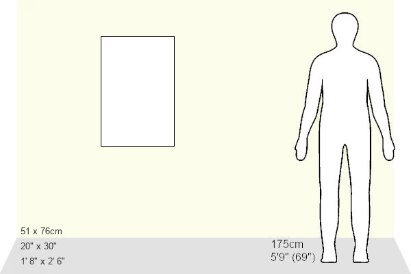
Made in the USA, 1014-piece puzzles measure 20" x 30" (50.8 x 76.2 cm). Every puzzle is meticulously printed on glossy photo paper, which has a strong 1.33 mm thickness. Delivered in a black storage cardboard box, these puzzles are both stylish and practical. (Note: puzzles contain small parts and are not suitable for children under 3 years of age.)
Jigsaw Puzzles are an ideal gift for any occasion
Estimated Product Size is 50.8cm x 76cm (20" x 29.9")
These are individually made so all sizes are approximate
Artwork printed orientated as per the preview above, with portrait (vertical) orientation to match the source image.
FEATURES IN THESE COLLECTIONS
> Arts
> Art Movements
> Medieval Art
> Europe
> France
> Canton
> Landes
> Europe
> Republic of Ireland
> Maps
> Europe
> United Kingdom
> England
> Maps
> Europe
> United Kingdom
> Maps
> Europe
> United Kingdom
> Wales
> Maps
> Europe
> United Kingdom
> Wales
> Posters
> Europe
> United Kingdom
> Wales
> Related Images
> North Wind Picture Archives
> British history
> North Wind Picture Archives
> Maps
EDITORS COMMENTS
This color lithograph reproduction takes us back in time to the era of Angevin kings and their vast holdings in France and Britain. The intricate illustration, dating back to the 19th century, beautifully depicts the territories ruled by this influential dynasty during the 12th to 15th centuries. The print showcases a detailed map that spans across Great Britain, Ireland, and France, highlighting the extensive reach of the Angevins. It offers a glimpse into an era characterized by medieval grandeur and historic significance. With its vintage charm and rich heritage, this artwork transports us to a time when England was under Plantagenet rule. The image evokes feelings of nostalgia as we explore the family's ancestral lands and envision life during those turbulent yet fascinating times. As we gaze upon this remarkable piece of art, it serves as a reminder of Europe's complex history. From Wales to Scotland, from Anjou to Brittany, these territories were once united under one powerful dynasty – shaping not only British but also French history. Whether you are an enthusiast for English or French history or simply appreciate art depicting significant moments from our past, this lithograph is sure to captivate your imagination with its depiction of Angevin power during the Middle Ages.
MADE IN THE USA
Safe Shipping with 30 Day Money Back Guarantee
FREE PERSONALISATION*
We are proud to offer a range of customisation features including Personalised Captions, Color Filters and Picture Zoom Tools
SECURE PAYMENTS
We happily accept a wide range of payment options so you can pay for the things you need in the way that is most convenient for you
* Options may vary by product and licensing agreement. Zoomed Pictures can be adjusted in the Cart.