Jigsaw Puzzle > Arts > Artists > O > Abraham Ortelius
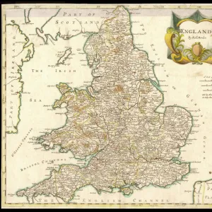
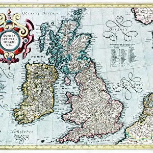
Jigsaw Puzzle : 16th century map of the British Isles


![]()
Jigsaw Puzzles from Science Photo Library
16th century map of the British Isles
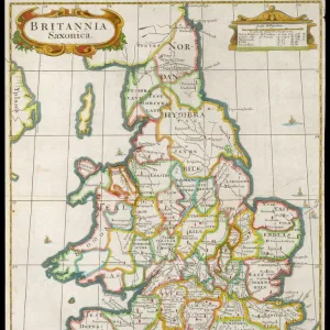
Map of the British Isles, in the 1570 edition of Ortelius Atlas (Theatrum Orbis Terrarum). Abraham Ortelius (1527-1598) was a Flemish mapmaker who is considered to have produced the first true atlas (collection of uniform maps in one book). Ortelius worked in Antwerp, the Netherlands. This map is titled: Angliae, Scotiae et Hiberniae (England, Scotland and Ireland). The text at upper right is in Latin and mentions Saxons and Albion (another term for Britain). A royal coat of arms is seen at lower left
Science Photo Library features Science and Medical images including photos and illustrations
Media ID 6348369
© LIBRARY OF CONGRESS, GEOGRAPHY AND MAP DIVISION/SCIENCE PHOTO LIBRARY
1500s 1570 16th Century Abraham Ortelius Ancient British Isles Cartography Coat Of Arms Country Diagram Dutch Flemish Illustrated Inaccurate Incomplete Ireland Irish Latin Nation Renaissance Scot Land Scottish Theatrum Orbis Terrarum Wales Welsh Library Of Congress
Jigsaw Puzzle (520 Pieces)
Discover the rich history of the British Isles with our captivating jigsaw puzzles from Media Storehouse. This exquisite puzzle features a rare and intriguing 16th century map of the British Isles, taken from the renowned 1570 edition of the Ortelius Atlas (Theatrum Orbis Terrarum). Produced by Flemish cartographer Abraham Ortelius, this map is considered the first true atlas in the history of cartography. Solve the puzzle pieces to reveal the intricate details of this historical treasure, bringing the mysteries of the past right into your home. Engage in a fun and educational experience as you piece together this stunning representation of the British Isles during an era of significant exploration and discovery.
Made in the USA, 520-piece puzzles measure 16" x 20" (40.6 x 50.8 cm). Every puzzle is meticulously printed on glossy photo paper, which has a strong 1.33 mm thickness. Delivered in a black storage cardboard box, these puzzles are both stylish and practical. (Note: puzzles contain small parts and are not suitable for children under 3 years of age.)
Jigsaw Puzzles are an ideal gift for any occasion
Estimated Product Size is 40.5cm x 50.8cm (15.9" x 20")
These are individually made so all sizes are approximate
Artwork printed orientated as per the preview above, with landscape (horizontal) or portrait (vertical) orientation to match the source image.
FEATURES IN THESE COLLECTIONS
> Arts
> Art Movements
> Renaissance Art
> Arts
> Artists
> O
> Abraham Ortelius
> Europe
> France
> Canton
> Landes
> Europe
> Netherlands
> Maps
> Europe
> Netherlands
> Posters
> Europe
> Netherlands
> Related Images
> Europe
> Republic of Ireland
> Maps
> Europe
> United Kingdom
> England
> Maps
> Europe
> United Kingdom
> Maps
> Europe
> United Kingdom
> Related Images
> Maps and Charts
> Abraham Ortelius
EDITORS COMMENTS
This print showcases a remarkable piece of history - a 16th-century map of the British Isles. Crafted by Abraham Ortelius, a renowned Flemish mapmaker and considered the pioneer of atlases, this particular map is part of his esteemed work, the 1570 edition of Ortelius Atlas (Theatrum Orbis Terrarum). Titled "Angliae, Scotiae et Hiberniae" which translates to England, Scotland, and Ireland in Latin, this intricate illustration provides a glimpse into the geographical landscape during that era. The text inscribed in Latin at the upper right corner mentions Saxons and Albion - an alternate term for Britain. One cannot help but be captivated by the royal coat of arms prominently displayed at lower left on this ancient cartographic masterpiece. It serves as a testament to the historical significance attached to these lands. While it's important to note that this 16th-century map may not be entirely accurate or complete according to modern standards, its artistic value and contribution to our understanding of British history are undeniable. This beautifully illustrated work offers us insights into how people perceived their world centuries ago. Preserved within the Library of Congress archives, this Dutch-Scottish collaboration between Ortelius and Scottish engraver Michael Fleming stands as an enduring symbol of cultural exchange during Europe's Renaissance period. A true treasure for enthusiasts interested in geography, history, artistry or simply those who appreciate glimpses into our past.
MADE IN THE USA
Safe Shipping with 30 Day Money Back Guarantee
FREE PERSONALISATION*
We are proud to offer a range of customisation features including Personalised Captions, Color Filters and Picture Zoom Tools
SECURE PAYMENTS
We happily accept a wide range of payment options so you can pay for the things you need in the way that is most convenient for you
* Options may vary by product and licensing agreement. Zoomed Pictures can be adjusted in the Cart.