Home > South America > Paraguay > Maps
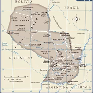
1855, Colton Map of Argentina, Chile, Paraguay and Uruguay, topography, cartography

![]()
Wall Art and Photo Gifts from Liszt Collection
1855, Colton Map of Argentina, Chile, Paraguay and Uruguay, topography, cartography
1855, Colton Map of Argentina, Chile, Paraguay and Uruguay
Liszt Collection of nineteenth-century engravings and images to browse and enjoy
Media ID 14005468
© Artokoloro Quint Lox Limited
1855 Chile Antique Map Atlas Chart Geographic Latitude Longitude Mappa Mundi Old Antique Plan Old Antique View Old Map Ols Antique Map Rare Old Maps Topo
FEATURES IN THESE COLLECTIONS
> Maps and Charts
> Early Maps
> Maps and Charts
> World
> South America
> Argentina
> Maps
> South America
> Chile
> Maps
> South America
> Paraguay
> Maps
> South America
> Uruguay
> Maps
EDITORS COMMENTS
This print showcases the remarkable 1855 Colton Map of Argentina, Chile, Paraguay, and Uruguay. A true masterpiece in topography and cartography, this vintage map offers a fascinating glimpse into the geography and land formations of these South American countries. With intricate illustrations and precise geographic details, this historic map takes us on a journey through time. Its decorative elements and artistic flair make it an exquisite piece of art that captures the essence of exploration and discovery during that era. The aged paper adds to its charm, evoking a sense of nostalgia for bygone times. As we gaze upon this rare old map, we are transported back to a world where navigation was guided by charts, grids, latitude lines, longitude markers - all meticulously arranged in geometric patterns. This antique treasure not only serves as a visual representation but also holds immense historical value. It sheds light on how our understanding of the Earth's regions has evolved over centuries. The Liszt Collection presents this exceptional photograph print with utmost care to preserve its authenticity. While it cannot be used commercially without permission due to copyright restrictions (not affiliated with any company), it remains an invaluable resource for historians, geographers or anyone fascinated by ancient maps and their significance in unraveling our past.
MADE IN THE USA
Safe Shipping with 30 Day Money Back Guarantee
FREE PERSONALISATION*
We are proud to offer a range of customisation features including Personalised Captions, Color Filters and Picture Zoom Tools
SECURE PAYMENTS
We happily accept a wide range of payment options so you can pay for the things you need in the way that is most convenient for you
* Options may vary by product and licensing agreement. Zoomed Pictures can be adjusted in the Cart.