Metal Print > Europe > France > Maps
Metal Print : Maps of the Caribbean Islands (Guadeloupe, Marie Galante, Dominica, Martinique


![]()
Metal Prints from Fine Art Finder
Maps of the Caribbean Islands (Guadeloupe, Marie Galante, Dominica, Martinique
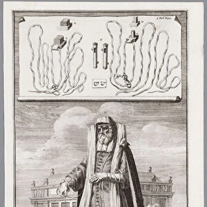
LRI4707035 Maps of the Caribbean Islands (Guadeloupe, Marie Galante, Dominica, Martinique, Saint Lucia, Saint Vincent, Barbados, Grenadines and Grenada) (etching, 1730) by Delisle, Guillaume (1675-1726); Private Collection; (add.info.: Maps of the Caribbean Islands (Guadeloupe, Marie Galante, Dominica, Martinique, Saint Lucia, Saint Vincent, Barbados, Grenadines and Grenada) - Strong water extracted from the " New Atlas containing all parts of the world" 1730 by Guillaume de L Isle (1675-1726)); Luisa Ricciarini; French, out of copyright
Media ID 22467762
© Luisa Ricciarini / Bridgeman Images
Atlas Book Caribbean Central America Dominium Guadeloupe Haiti Martinican Martinique Geographical Map
16"x20" (51x41cm) Metal Print
Discover the enchanting beauty of the Caribbean with our Media Storehouse Metal Prints featuring a captivating map collection. This exquisite artwork, titled "Maps of the Caribbean Islands (Guadeloupe, Marie Galante, Dominica, Martinique, Saint Lucia, Saint Vincent, Barbados, Grenadines and Grenada)" by Luisa Ricciarini, is inspired by an original etching from 1730 by Delisle. Each Metal Print is meticulously crafted, bringing the intricate details and vibrant colors of this historical map to life. Transform your space into a tropical paradise with this stunning piece of decorative art.
Made with durable metal and luxurious printing techniques, our metal photo prints go beyond traditional canvases, adding a cool, modern touch to your space. Wall mount on back. Eco-friendly 100% post-consumer recycled ChromaLuxe aluminum surface. The thickness of the print is 0.045". Featuring a Scratch-resistant surface and Rounded corners. Backing hangers are attached to the back of the print and float the print 1/2-inch off the wall when hung, the choice of hanger may vary depending on size and International orders will come with Float Mount hangers only. Finished with a brilliant white high gloss surface for unsurpassed detail and vibrance. Printed using Dye-Sublimation and for best care we recommend a non-ammonia glass cleaner, water, or isopropyl (rubbing) alcohol to prevent harming the print surface. We recommend using a clean, lint-free cloth to wipe off the print. The ultra-hard surface is scratch-resistant, waterproof and weatherproof. Avoid direct sunlight exposure.
Made with durable metal and luxurious printing techniques, metal prints bring images to life and add a modern touch to any space
Estimated Image Size (if not cropped) is 50.8cm x 40.6cm (20" x 16")
Estimated Product Size is 51.4cm x 41.2cm (20.2" x 16.2")
These are individually made so all sizes are approximate
Artwork printed orientated as per the preview above, with landscape (horizontal) orientation to match the source image.
FEATURES IN THESE COLLECTIONS
> Fine Art Finder
> Artists
> Franz Hogenberg
> Fine Art Finder
> Artists
> Guillaume Delisle
> Maps and Charts
> Related Images
> Maps and Charts
> World
> North America
> Barbados
> Maps
> North America
> Barbados
> Related Images
> North America
> Dominica
> Maps
> North America
> Dominica
> Related Images
> North America
> Grenada
> Maps
EDITORS COMMENTS
This print showcases the intricate and detailed maps of the Caribbean Islands, including Guadeloupe, Marie Galante, Dominica, Martinique, Saint Lucia, Saint Vincent, Barbados, Grenadines and Grenada. Created by renowned cartographer Guillaume de L'Isle in 1730 as part of his "New Atlas containing all parts of the world" these etchings provide a fascinating glimpse into the geography and topography of this stunning region. The strong water extracted from this historical atlas brings to life the beauty and complexity of each island. From the lush landscapes to the crystal-clear waters that surround them, these maps offer a visual feast for any lover of geography or history. The engravings capture not only the physical features but also highlight important landmarks and settlements on each island. As we delve into this artwork by Luisa Ricciarini, we are transported back to a time when exploration was at its peak. These maps were essential tools for sailors navigating through treacherous waters and discovering new territories in Central America. They hold within their lines stories of conquests and trade routes that shaped both local cultures and global history. Whether you have an affinity for cartography or simply appreciate beautiful artistry, this print is sure to captivate your imagination. It serves as a reminder of our planet's rich history while also celebrating the natural wonders found within these Caribbean islands.
MADE IN THE USA
Safe Shipping with 30 Day Money Back Guarantee
FREE PERSONALISATION*
We are proud to offer a range of customisation features including Personalised Captions, Color Filters and Picture Zoom Tools
SECURE PAYMENTS
We happily accept a wide range of payment options so you can pay for the things you need in the way that is most convenient for you
* Options may vary by product and licensing agreement. Zoomed Pictures can be adjusted in the Cart.