Metal Print > Europe > United Kingdom > Northern Ireland > Maps
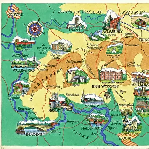
Metal Print : British - French Claims to North America, 1756


![]()
Metal Prints from Fine Art Finder
British - French Claims to North America, 1756
2902790 British - French Claims to North America, 1756; (add.info.: British - French Claims to North America, 1756.); Buyenlarge Archive/UIG
Media ID 38414570
© Buyenlarge Archive/UIG / Bridgeman Images
1750s Cartographic Settlements
16"x20" (51x41cm) Metal Print
Step back in time with our Metal Prints from the Media Storehouse range! This stunning piece, 'British - French Claims to North America, 1756' by Bridgeman Images from Fine Art Finder (Buyenlarge Archive/ UIG), brings history to life. A detailed map of competing claims between British and French colonies in North America during the mid-18th century is now available as a modern metal print. Perfect for historians, geography enthusiasts, or anyone looking to add a touch of vintage flair to their space.
Made with durable metal and luxurious printing techniques, our metal photo prints go beyond traditional canvases, adding a cool, modern touch to your space. Wall mount on back. Eco-friendly 100% post-consumer recycled ChromaLuxe aluminum surface. The thickness of the print is 0.045". Featuring a Scratch-resistant surface and Rounded corners. Backing hangers are attached to the back of the print and float the print 1/2-inch off the wall when hung, the choice of hanger may vary depending on size and International orders will come with Float Mount hangers only. Finished with a brilliant white high gloss surface for unsurpassed detail and vibrance. Printed using Dye-Sublimation and for best care we recommend a non-ammonia glass cleaner, water, or isopropyl (rubbing) alcohol to prevent harming the print surface. We recommend using a clean, lint-free cloth to wipe off the print. The ultra-hard surface is scratch-resistant, waterproof and weatherproof. Avoid direct sunlight exposure.
Made with durable metal and luxurious printing techniques, metal prints bring images to life and add a modern touch to any space
Estimated Image Size (if not cropped) is 50.8cm x 40.6cm (20" x 16")
Estimated Product Size is 51.4cm x 41.2cm (20.2" x 16.2")
These are individually made so all sizes are approximate
Artwork printed orientated as per the preview above, with landscape (horizontal) orientation to match the source image.
FEATURES IN THESE COLLECTIONS
> Fine Art Finder
> Artists
> Raymond de la Neziere
> Europe
> Republic of Ireland
> Maps
> Europe
> United Kingdom
> England
> Maps
> Europe
> United Kingdom
> Maps
> Europe
> United Kingdom
> Northern Ireland
> Maps
> Europe
> United Kingdom
> Northern Ireland
> Posters
> Europe
> United Kingdom
> Northern Ireland
> Related Images
EDITORS COMMENTS
This stunning print captures the intricate web of British and French claims to North America in 1756. The map is a visual representation of the fierce competition between these two colonial powers for control over vast territories across the continent.
The detailed cartography highlights the strategic importance of key settlements and trading posts, as well as the vast expanses of uncharted land waiting to be claimed. Each line and boundary on the map tells a story of exploration, conquest, and conflict that shaped the history of North America during this pivotal period.
As you study this historical document, you can almost feel the tension between Britain and France as they jockeyed for dominance in this new world. The intricate details reveal not just geographical boundaries, but also political ambitions and economic interests that drove these empires to expand their influence across oceans.
This print serves as a reminder of the complex tapestry of colonial rivalries that defined this era, setting the stage for future conflicts and alliances that would ultimately shape modern-day North America. It is a fascinating glimpse into a time when maps were more than just navigational tools – they were symbols of power, ambition, and territorial control.
MADE IN THE USA
Safe Shipping with 30 Day Money Back Guarantee
FREE PERSONALISATION*
We are proud to offer a range of customisation features including Personalised Captions, Color Filters and Picture Zoom Tools
SECURE PAYMENTS
We happily accept a wide range of payment options so you can pay for the things you need in the way that is most convenient for you
* Options may vary by product and licensing agreement. Zoomed Pictures can be adjusted in the Cart.