Premium Framed Print > Europe > United Kingdom > Northern Ireland > Maps
Premium Framed Print : British - French Claims to North America, 1756


![]()
Framed Photos from Fine Art Finder
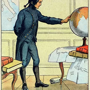
British - French Claims to North America, 1756
2902790 British - French Claims to North America, 1756; (add.info.: British - French Claims to North America, 1756.); Buyenlarge Archive/UIG
Media ID 38414570
© Buyenlarge Archive/UIG / Bridgeman Images
1750s Cartographic Settlements
14"x16" Premium Frame
Contemporary style Premium Wooden Frame with 8"x10" Print. Complete with 2" White Mat and 1.25" thick MDF frame. Printed on 260 gsm premium paper. Glazed with shatter proof UV coated acrylic glass. Backing is paper covered backing with rubber bumpers. Supplied ready to hang with a pre-installed sawtooth/wire hanger. Care Instructions: Spot clean with a damp cloth. Securely packaged in a clear plastic bag and envelope in a reinforced cardboard shipper
FSC Real Wood Frame and Double Mounted with White Conservation Mountboard - Professionally Made and Ready to Hang
Estimated Image Size (if not cropped) is 25.4cm x 20.3cm (10" x 8")
Estimated Product Size is 40.6cm x 35.6cm (16" x 14")
These are individually made so all sizes are approximate
Artwork printed orientated as per the preview above, with landscape (horizontal) orientation to match the source image.
FEATURES IN THESE COLLECTIONS
> Fine Art Finder
> Artists
> Raymond de la Neziere
> Europe
> Republic of Ireland
> Maps
> Europe
> United Kingdom
> England
> Maps
> Europe
> United Kingdom
> Maps
> Europe
> United Kingdom
> Northern Ireland
> Maps
> Europe
> United Kingdom
> Northern Ireland
> Posters
> Europe
> United Kingdom
> Northern Ireland
> Related Images
EDITORS COMMENTS
This stunning print captures the intricate web of British and French claims to North America in 1756. The map is a visual representation of the fierce competition between these two colonial powers for control over vast territories across the continent.
The detailed cartography highlights the strategic importance of key settlements and trading posts, as well as the vast expanses of uncharted land waiting to be claimed. Each line and boundary on the map tells a story of exploration, conquest, and conflict that shaped the history of North America during this pivotal period.
As you study this historical document, you can almost feel the tension between Britain and France as they jockeyed for dominance in this new world. The intricate details reveal not just geographical boundaries, but also political ambitions and economic interests that drove these empires to expand their influence across oceans.
This print serves as a reminder of the complex tapestry of colonial rivalries that defined this era, setting the stage for future conflicts and alliances that would ultimately shape modern-day North America. It is a fascinating glimpse into a time when maps were more than just navigational tools – they were symbols of power, ambition, and territorial control.
MADE IN THE USA
Safe Shipping with 30 Day Money Back Guarantee
FREE PERSONALISATION*
We are proud to offer a range of customisation features including Personalised Captions, Color Filters and Picture Zoom Tools
SECURE PAYMENTS
We happily accept a wide range of payment options so you can pay for the things you need in the way that is most convenient for you
* Options may vary by product and licensing agreement. Zoomed Pictures can be adjusted in the Cart.