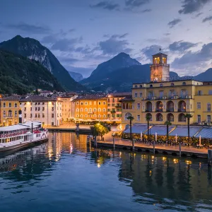
Metal Print > Europe > Italy > Lakes > Lake Garda
Metal Print : Map of the Coast of Guiana, 1646-47


![]()
Metal Prints from Fine Art Finder
Map of the Coast of Guiana, 1646-47
3786720 Map of the Coast of Guiana, 1646-47; (add.info.: Map of the Coast of Guiana - published in Dudleys Dell Arcano del Mare, 1646- 47. Sir Robert Dudley (1574-1649) was an English explorer and cartographer who lived in Italy in the 17th century and styled himself as Duke of Northumberland; son of Robert Dudley, Earl of Leicester
Old Decorative Maps and Charts by Arthur L. Humphreys, 1926. Plate 55); Lebrecht History
Media ID 23146486
© Lebrecht History / Bridgeman Images
Acconciatura Baldaquin Battistero Bin Ass1 Cartographer Ceiling City Map City Plan Countries Draughtsman Dull Gret Earth Earth Globe French Guiana General Map Globe Globe Of The Earth High And Late Renaissance Illustrating Lake Garda Latinamerica Seventeenth Southamerica Street Plan Terrestrial Zebra Four Elements Latine America Renaissance Time
16"x24" (61x41cm) Metal Print
Discover history with our exquisite Metal Prints featuring the Map of the Coast of Guiana, 1646-47 from Bridgeman Images. This intriguing map, originally published in Dudleys Dell Arcano del Mare, offers a fascinating glimpse into the cartographic explorations of the 17th century. Each Metal Print is meticulously crafted to bring out the rich details and vibrant colors of the original image, ensuring a stunning addition to any room in your home or office. Experience the allure of historical cartography with our high-quality, long-lasting Metal Prints.
Made with durable metal and luxurious printing techniques, our metal photo prints go beyond traditional canvases, adding a cool, modern touch to your space. Wall mount on back. Eco-friendly 100% post-consumer recycled ChromaLuxe aluminum surface. The thickness of the print is 0.045". Featuring a Scratch-resistant surface and Rounded corners. Backing hangers are attached to the back of the print and float the print 1/2-inch off the wall when hung, the choice of hanger may vary depending on size and International orders will come with Float Mount hangers only. Finished with a brilliant white high gloss surface for unsurpassed detail and vibrance. Printed using Dye-Sublimation and for best care we recommend a non-ammonia glass cleaner, water, or isopropyl (rubbing) alcohol to prevent harming the print surface. We recommend using a clean, lint-free cloth to wipe off the print. The ultra-hard surface is scratch-resistant, waterproof and weatherproof. Avoid direct sunlight exposure.
Made with durable metal and luxurious printing techniques, metal prints bring images to life and add a modern touch to any space
Estimated Product Size is 61.5cm x 41.2cm (24.2" x 16.2")
These are individually made so all sizes are approximate
Artwork printed orientated as per the preview above, with landscape (horizontal) orientation to match the source image.
FEATURES IN THESE COLLECTIONS
> Fine Art Finder
> Artists
> William Brassey Hole
> Fine Art Finder
> Maps (celestial & Terrestrial)
> Arts
> Art Movements
> Renaissance Art
> Arts
> Artists
> W
> Robert White
> Arts
> Portraits
> Pop art gallery
> Street art portraits
> Europe
> France
> Lakes
> Related Images
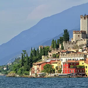
> Europe
> Italy
> Lakes
> Lake Garda
> Europe
> Italy
> Lakes
> Related Images
> Europe
> United Kingdom
> England
> Northumberland
> Related Images
EDITORS COMMENTS
This print showcases the "Map of the Coast of Guiana" from 1646-47, a remarkable piece of cartography published in Dudleys Dell Arcano del Mare. Created by Sir Robert Dudley, an English explorer and cartographer who resided in Italy during the 17th century, this map offers a glimpse into the intricate details and artistry of early mapmaking. Sir Robert Dudley, also known as Duke of Northumberland, was renowned for his expertise in mapping and exploration. The son of Robert Dudley, Earl of Leicester, he dedicated himself to charting unexplored territories with great precision and creativity. Displayed against a backdrop reminiscent of old decorative maps and charts from Arthur L. Humphreys' collection in 1926, this particular print captures the essence of seventeenth-century South America. With its delicate illustrations and meticulous attention to geographical accuracy, it transports viewers back to a time when cartographers were revered for their ability to bring distant lands closer through their craft. The black-and-white aesthetic adds a touch of nostalgia while emphasizing the historical significance embedded within each stroke. From city plans to street layouts, every detail is meticulously depicted on this general map that encompasses both beauty and functionality. As we admire this masterpiece from Bridgeman Images' Fine Art Finder collection today, we are reminded not only of Sir Robert Dudley's contribution but also how art can transcend time by preserving our collective history for generations to come.
MADE IN THE USA
Safe Shipping with 30 Day Money Back Guarantee
FREE PERSONALISATION*
We are proud to offer a range of customisation features including Personalised Captions, Color Filters and Picture Zoom Tools
SECURE PAYMENTS
We happily accept a wide range of payment options so you can pay for the things you need in the way that is most convenient for you
* Options may vary by product and licensing agreement. Zoomed Pictures can be adjusted in the Cart.