Metal Print > Europe > United Kingdom > England > London > Sights > British Museum
Metal Print : Map of Mesopotamia


![]()
Metal Prints from Science Photo Library
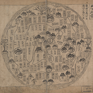
Map of Mesopotamia
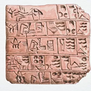
Map of Mesopotamia. Computer artwork of markings on a stone tablet showing a map of Mesopotamia. The stone tablet dates from between 700 and 500 BC and is from Sippar in southern Iraq. The ancient city of Babylon is the rectangle located at the centre of the map. Cuneiform script elsewhere on the tablet also mentions Assyria and Elam. The Mesopotamian world is surrounded by a circular waterway labelled salt-sea. Triangular regions, or islands, beyond the sea were thought to be home to mythical creatures. Mesopotamia refers to a region between the Tigris and Euphrates rivers in what is now Iraq. The stone tablet is kept in the British Museum
Science Photo Library features Science and Medical images including photos and illustrations
Media ID 6350463
© SHEILA TERRY/SCIENCE PHOTO LIBRARY
Ancient Anthropology Antiquity Archaeology Babylon Babylonian Cartography Classical Cuneiform Earth Science Graphic Inscription Iraq Island Islands Land Mapping Maps Mesopotamia Middle East Mythological Mythology Region Regions Sciences Assyria Cartographical Computer Artwork Elam Iraqi Sippar Stone Tablet
20"x24" (61x51cm) Metal Print
Discover the rich history of Mesopotamia with our stunning Metal Prints from Media Storehouse. Featuring an intricately detailed map of Mesopotamia from the Science Photo Library, this print brings the ancient world to life. Each Metal Print is crafted with precision and care, using high-quality metal sheets to create a vibrant, long-lasting image. The contrast between the map's intricate lines and the sleek, modern metal surface creates a unique and eye-catching display. Transport yourself back in time and add a touch of history to your home or office with this beautiful and educational piece.
Made with durable metal and luxurious printing techniques, our metal photo prints go beyond traditional canvases, adding a cool, modern touch to your space. Wall mount on back. Eco-friendly 100% post-consumer recycled ChromaLuxe aluminum surface. The thickness of the print is 0.045". Featuring a Scratch-resistant surface and Rounded corners. Backing hangers are attached to the back of the print and float the print 1/2-inch off the wall when hung, the choice of hanger may vary depending on size and International orders will come with Float Mount hangers only. Finished with a brilliant white high gloss surface for unsurpassed detail and vibrance. Printed using Dye-Sublimation and for best care we recommend a non-ammonia glass cleaner, water, or isopropyl (rubbing) alcohol to prevent harming the print surface. We recommend using a clean, lint-free cloth to wipe off the print. The ultra-hard surface is scratch-resistant, waterproof and weatherproof. Avoid direct sunlight exposure.
Made with durable metal and luxurious printing techniques, metal prints bring images to life and add a modern touch to any space
Estimated Image Size (if not cropped) is 60.9cm x 50.8cm (24" x 20")
Estimated Product Size is 61.5cm x 51.4cm (24.2" x 20.2")
These are individually made so all sizes are approximate
Artwork printed orientated as per the preview above, with landscape (horizontal) orientation to match the source image.
FEATURES IN THESE COLLECTIONS
> Arts
> Artists
> B
> Babylonian Babylonian
> Arts
> Landscape paintings
> Waterfall and river artworks
> River artworks
> Asia
> Iraq
> Related Images
> Europe
> France
> Canton
> Landes
> Europe
> United Kingdom
> England
> London
> Sights
> British Museum
> Historic
> Ancient civilizations
> Mesopotamia
> Ancient Mesopotamian art
> Historic
> Ancient civilizations
> Mesopotamia
> Ancient Mesopotamian cities
> Historic
> Ancient civilizations
> Mesopotamia
> Cuneiform tablets
> Maps and Charts
> Early Maps
EDITORS COMMENTS
This print showcases a remarkable computer artwork of markings on a stone tablet, revealing an ancient map of Mesopotamia. Dating back to the period between 700 and 500 BC, this historical artifact was discovered in Sippar, located in southern Iraq. At the heart of this intricate map lies the renowned city of Babylon, depicted as a rectangular shape. The tablet's cuneiform script also references other prominent regions such as Assyria and Elam. Surrounding the Mesopotamian world is a circular waterway labeled as the salt-sea. Beyond this vast expanse lie triangular regions or islands that were believed to be inhabited by mythical creatures, adding an element of mystique to this ancient depiction. Mesopotamia itself refers to the region situated between the Tigris and Euphrates rivers in what is now modern-day Iraq. Preserved within the esteemed British Museum, this stone tablet offers invaluable insights into classical geography and serves as a testament to our understanding of antiquity. With its rich history and cultural significance, this image not only appeals to archaeology enthusiasts but also captivates those interested in mythology, anthropology, cartography, and earth sciences. It allows us to delve into an era long gone while marveling at humanity's early attempts at mapping their surroundings.
MADE IN THE USA
Safe Shipping with 30 Day Money Back Guarantee
FREE PERSONALISATION*
We are proud to offer a range of customisation features including Personalised Captions, Color Filters and Picture Zoom Tools
SECURE PAYMENTS
We happily accept a wide range of payment options so you can pay for the things you need in the way that is most convenient for you
* Options may vary by product and licensing agreement. Zoomed Pictures can be adjusted in the Cart.