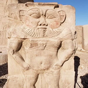
Photographic Print > Africa > Egypt > Maps
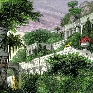
Photographic Print : Map of Assyria Chaldea and adjacent countries. From Cassells Universal History, published 1888; Illustration


![]()
Photo Prints from Design Pics
Map of Assyria Chaldea and adjacent countries. From Cassells Universal History, published 1888; Illustration
Design Pics offers Distinctively Different Imagery representing over 1,500 contributors
Media ID 24906593
© Ken Welsh
Ancient Ancient Civilization Ancient Civilizations Assyria Babylonia Black And White Image Cartography Countries Egypt Egyptian Geographical Geography Historic And Vintage Illustrations Maps Maps Globes And Flags Mesopotamia Prints Chaldea
10"x8" Photo Print
Step back in time with our vintage Map of Assyria Chaldea and adjacent countries from the Cassells Universal History, published in 1888. This exquisite photographic print, captured by Ken Welsh from Design Pics, showcases intricate details of ancient geography. Add an air of historical sophistication to your home or office decor with this captivating and authentic piece, perfect for history enthusiasts and world travelers alike.
Photo prints are produced on Kodak professional photo paper resulting in timeless and breath-taking prints which are also ideal for framing. The colors produced are rich and vivid, with accurate blacks and pristine whites, resulting in prints that are truly timeless and magnificent. Whether you're looking to display your prints in your home, office, or gallery, our range of photographic prints are sure to impress. Dimensions refers to the size of the paper in inches.
Our Photo Prints are in a large range of sizes and are printed on Archival Quality Paper for excellent colour reproduction and longevity. They are ideal for framing (our Framed Prints use these) at a reasonable cost. Alternatives include cheaper Poster Prints and higher quality Fine Art Paper, the choice of which is largely dependant on your budget.
Estimated Image Size (if not cropped) is 25.4cm x 18.2cm (10" x 7.2")
Estimated Product Size is 25.4cm x 20.3cm (10" x 8")
These are individually made so all sizes are approximate
Artwork printed orientated as per the preview above, with landscape (horizontal) orientation to match the source image.
FEATURES IN THESE COLLECTIONS
> Africa
> Egypt
> Related Images
> Historic
> Ancient civilizations
> Ancient Egypt
> Historic
> Ancient civilizations
> Mesopotamia
> Historic
> Ancient civilizations
> Maps and Charts
> Early Maps
EDITORS COMMENTS
This vintage print showcases a detailed "Map of Assyria Chaldea and adjacent countries" from Cassells Universal History, published in 1888. The illustration takes us back to the ancient world, providing a glimpse into the geography and historical significance of Mesopotamia, Babylonia, and their neighboring regions. The engraving captures the intricate coastlines along the Great Sea (Mediterranean Sea) as well as other nearby countries such as Egypt. It offers an archival perspective on how these lands were interconnected during that period. The map serves as a valuable resource for historians, scholars, or anyone fascinated by ancient civilizations. Its cartography allows us to trace the boundaries of different nations while highlighting key landmarks and cities within Assyria Chaldea. As we explore this piece of history through Ken Welsh's lens, it is evident that this print holds immense historical value. Its inclusion in Cassells Universal History signifies its importance in documenting past cultures and societies. Whether displayed for educational purposes or admired for its aesthetic appeal, this horizontal vintage print transports us back to a time when these lands were at the forefront of human civilization.
MADE IN THE USA
Safe Shipping with 30 Day Money Back Guarantee
FREE PERSONALISATION*
We are proud to offer a range of customisation features including Personalised Captions, Color Filters and Picture Zoom Tools
SECURE PAYMENTS
We happily accept a wide range of payment options so you can pay for the things you need in the way that is most convenient for you
* Options may vary by product and licensing agreement. Zoomed Pictures can be adjusted in the Cart.