Premium Framed Print > Africa > Egypt > Maps
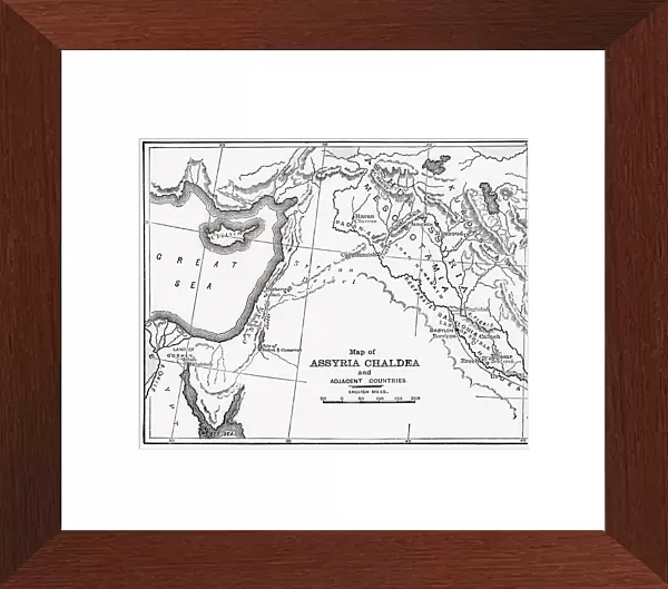
Premium Framed Print : Map of Assyria Chaldea and adjacent countries. From Cassells Universal History, published 1888; Illustration


![]()
Framed Photos from Design Pics
Map of Assyria Chaldea and adjacent countries. From Cassells Universal History, published 1888; Illustration
Design Pics offers Distinctively Different Imagery representing over 1,500 contributors
Media ID 24906593
© Ken Welsh
Ancient Ancient Civilization Ancient Civilizations Assyria Babylonia Black And White Image Cartography Countries Egypt Egyptian Geographical Geography Historic And Vintage Illustrations Maps Maps Globes And Flags Mesopotamia Prints Chaldea
14"x16" Premium Frame
Contemporary style Premium Wooden Frame with 8"x10" Print. Complete with 2" White Mat and 1.25" thick MDF frame. Printed on 260 gsm premium paper. Glazed with shatter proof UV coated acrylic glass. Backing is paper covered backing with rubber bumpers. Supplied ready to hang with a pre-installed sawtooth/wire hanger. Care Instructions: Spot clean with a damp cloth. Securely packaged in a clear plastic bag and envelope in a reinforced cardboard shipper
FSC Real Wood Frame and Double Mounted with White Conservation Mountboard - Professionally Made and Ready to Hang
Estimated Image Size (if not cropped) is 25.4cm x 20.3cm (10" x 8")
Estimated Product Size is 40.6cm x 35.6cm (16" x 14")
These are individually made so all sizes are approximate
Artwork printed orientated as per the preview above, with landscape (horizontal) orientation to match the source image.
FEATURES IN THESE COLLECTIONS
> Africa
> Egypt
> Related Images
> Historic
> Ancient civilizations
> Ancient Egypt
> Historic
> Ancient civilizations
> Mesopotamia
> Historic
> Ancient civilizations
> Maps and Charts
> Early Maps
> Maps and Charts
> Related Images
EDITORS COMMENTS
This vintage print showcases a detailed "Map of Assyria Chaldea and adjacent countries" from Cassells Universal History, published in 1888. The illustration takes us back to the ancient world, providing a glimpse into the geography and historical significance of Mesopotamia, Babylonia, and their neighboring regions. The engraving captures the intricate coastlines along the Great Sea (Mediterranean Sea) as well as other nearby countries such as Egypt. It offers an archival perspective on how these lands were interconnected during that period. The map serves as a valuable resource for historians, scholars, or anyone fascinated by ancient civilizations. Its cartography allows us to trace the boundaries of different nations while highlighting key landmarks and cities within Assyria Chaldea. As we explore this piece of history through Ken Welsh's lens, it is evident that this print holds immense historical value. Its inclusion in Cassells Universal History signifies its importance in documenting past cultures and societies. Whether displayed for educational purposes or admired for its aesthetic appeal, this horizontal vintage print transports us back to a time when these lands were at the forefront of human civilization.
MADE IN THE USA
Safe Shipping with 30 Day Money Back Guarantee
FREE PERSONALISATION*
We are proud to offer a range of customisation features including Personalised Captions, Color Filters and Picture Zoom Tools
SECURE PAYMENTS
We happily accept a wide range of payment options so you can pay for the things you need in the way that is most convenient for you
* Options may vary by product and licensing agreement. Zoomed Pictures can be adjusted in the Cart.