Photographic Print > Europe > Italy > Lazio > Rome
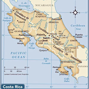
Photographic Print : Geography map: representation of the border area between Nicaragua and Costa Rica in Central America, made by Dutch cartographer Gerard van Keulen (1678-1726) 1709-1713. Biblioteca Angelica, Rome
 1709-1713. Biblioteca Angelica, Rome")

![]()
Photo Prints from Fine Art Finder
Geography map: representation of the border area between Nicaragua and Costa Rica in Central America, made by Dutch cartographer Gerard van Keulen (1678-1726) 1709-1713. Biblioteca Angelica, Rome
VEN5030233 Geography map: representation of the border area between Nicaragua and Costa Rica in Central America, made by Dutch cartographer Gerard van Keulen (1678-1726) 1709-1713. Biblioteca Angelica, Rome; (add.info.: Geography map: representation of the border area between Nicaragua and Costa Rica in Central America, made by Dutch cartographer Gerard van Keulen (1678-1726) 1709-1713. Biblioteca Angelica, Rome); © Marage Photos
Media ID 38167648
© © Marage Photos / Bridgeman Images
Amerique Centrale Amerique Du Nord Carte Geographique Central America Etats Unis Geographie Stockravenna 18eme Siecle Geographical Map
11"x8.5" Photo Print
Explore the intricate details of historical cartography with this stunning print showcasing the border area between Nicaragua and Costa Rica in Central America. Created by Dutch cartographer Gerard van Keulen in the early 18th century, this piece from Fine Art Finder is a unique addition to any art collection.
Photo prints are produced on Kodak professional photo paper resulting in timeless and breath-taking prints which are also ideal for framing. The colors produced are rich and vivid, with accurate blacks and pristine whites, resulting in prints that are truly timeless and magnificent. Whether you're looking to display your prints in your home, office, or gallery, our range of photographic prints are sure to impress. Dimensions refers to the size of the paper in inches.
Our Photo Prints are in a large range of sizes and are printed on Archival Quality Paper for excellent colour reproduction and longevity. They are ideal for framing (our Framed Prints use these) at a reasonable cost. Alternatives include cheaper Poster Prints and higher quality Fine Art Paper, the choice of which is largely dependant on your budget.
Estimated Image Size (if not cropped) is 27.9cm x 18.6cm (11" x 7.3")
Estimated Product Size is 27.9cm x 21.6cm (11" x 8.5")
These are individually made so all sizes are approximate
Artwork printed orientated as per the preview above, with landscape (horizontal) orientation to match the source image.
FEATURES IN THESE COLLECTIONS
> Fine Art Finder
> Artists
> Unknown Artist
> Europe
> Italy
> Lazio
> Rome
> Maps and Charts
> Early Maps
> Maps and Charts
> Related Images
> North America
> Costa Rica
> Maps
> North America
> Costa Rica
> Related Images
> North America
> Nicaragua
> Maps
> North America
> Nicaragua
> Related Images
> North America
> United States of America
> Maps
EDITORS COMMENTS
This stunning print showcases a detailed geography map of the border area between Nicaragua and Costa Rica in Central America, created by the talented Dutch cartographer Gerard van Keulen between 1709-1713. The intricate details and precision of this map offer a glimpse into the historical boundaries and topography of this region during the early 18th century.
The map, housed at Biblioteca Angelica in Rome, is a testament to Van Keulen's expertise in cartography and his dedication to accurately representing geographical features. From rivers to mountains, each element on the map is meticulously drawn with care and precision.
As we study this piece of art, we are transported back in time to an era when exploration and discovery were paramount. The borders between Nicaragua and Costa Rica come alive on paper, showcasing the intricacies of land divisions and natural landmarks that define these two countries.
This print serves as a reminder of the importance of maps in understanding our world's history and geography. It is a true masterpiece that not only educates but also captivates viewers with its beauty and detail.
MADE IN THE USA
Safe Shipping with 30 Day Money Back Guarantee
FREE PERSONALISATION*
We are proud to offer a range of customisation features including Personalised Captions, Color Filters and Picture Zoom Tools
SECURE PAYMENTS
We happily accept a wide range of payment options so you can pay for the things you need in the way that is most convenient for you
* Options may vary by product and licensing agreement. Zoomed Pictures can be adjusted in the Cart.