Poster Print > Arts > Photorealistic artworks > Detailed art pieces > Masterful detailing in art
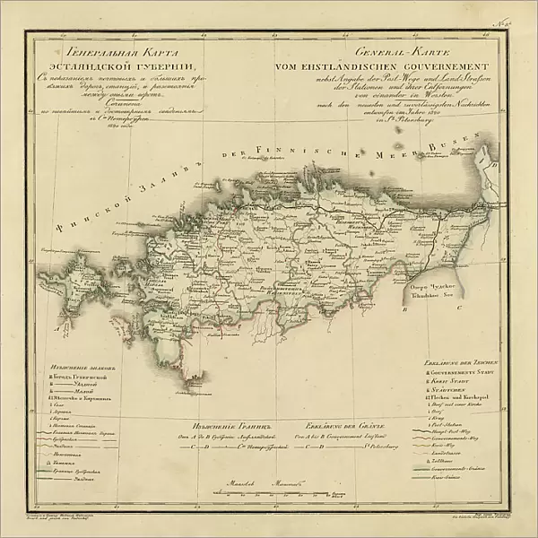
Poster Print : General Map of Estland Province: Showing Postal and Major Roads, Stations and... 1820. Creators: Vasilii Petrovich Piadyshev, Faleleef

![]()
Poster Prints from Heritage Images
General Map of Estland Province: Showing Postal and Major Roads, Stations and... 1820. Creators: Vasilii Petrovich Piadyshev, Faleleef
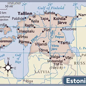
General Map of Estland Province: Showing Postal and Major Roads, Stations and the Distance in Versts between Them, 1820. This 1820 map of Estland Province is from a larger work, Geograficheskii atlas Rossiiskoi imperii, tsarstva Pol'skogo i velikogo kniazhestva Finliandskogo(Geographical atlas of the Russian Empire, the Kingdom of Poland, and the Grand Duchy of Finland), containing 60 maps of the Russian Empire. Compiled and engraved by Colonel V.P. Piadyshev, it reflects the detailed mapping carried out by Russian military cartographers in the first quarter of the 19th century. The map shows population centers (six gradations by size), postal stations, roads (four types), provincial and district borders, and customs houses. Distances are shown in versts, a Russian measure, now no longer used, equal to 1.07 kilometers.Legends and place-names are in Russian and German. The territory depicted on the map corresponds to the northern part of present-day Estonia
Heritage Images features heritage image collections
Media ID 35127123
© Heritage Art/Heritage Images
1820s Atlas Border Borders Cartographic Cartography Communication Customs House Cyrillic Estland Faleleef Legend Map Making Mapmaking Piadyshev Vasilii Petrovich Population Roads Russian Empire Russian Federation Thoroughfare Vasilii Petrovich Piadyshev Vp Piadyshev Meeting Of Frontiers Postal Service
27x27 inch Poster Print
Discover the historical charm of Estland Province with our exquisite poster print from Media Storehouse. This detailed map, created by Vasilii Petrovich Piadyshev and Faleleef in 1820, showcases the major roads, postal routes, and stations of Estland Province. A must-have for history enthusiasts and collectors, this vintage map transports you back in time, offering a glimpse into the past through intricate cartography and meticulous detailing. Bring a piece of historical cartography into your home or office with our authentic and high-quality poster print.
Poster prints are budget friendly enlarged prints in standard poster paper sizes. Printed on 150 gsm Matte Paper for a natural feel and supplied rolled in a tube. Great for framing and should last many years. To clean wipe with a microfiber, non-abrasive cloth or napkin. Our Archival Quality Photo Prints and Fine Art Paper Prints are printed on higher quality paper and the choice of which largely depends on your budget.
Poster prints are budget friendly enlarged prints in standard poster paper sizes (A0, A1, A2, A3 etc). Whilst poster paper is sometimes thinner and less durable than our other paper types, they are still ok for framing and should last many years. Our Archival Quality Photo Prints and Fine Art Paper Prints are printed on higher quality paper and the choice of which largely depends on your budget.
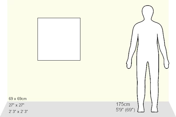
Estimated Product Size is 69.2cm x 69.2cm (27.2" x 27.2")
These are individually made so all sizes are approximate
Artwork printed orientated as per the preview above, with landscape (horizontal) or portrait (vertical) orientation to match the source image.
FEATURES IN THESE COLLECTIONS
> Animals
> Mammals
> Muridae
> House Mouse
> Arts
> Photorealistic artworks
> Detailed art pieces
> Masterful detailing in art
> Europe
> Estonia
> Related Images
> Europe
> Finland
> Related Images
EDITORS COMMENTS
This historic map print, titled "General Map of Estland Province: Showing Postal and Major Roads, Stations and the Distance in Versts between Them," dates back to 1820. It is an extract from the larger work, "Geograficheskii atlas Rossiiskoi imperii, tsarstva Pol'skogo i velikogo kniazhestva Finliandskogo" (Geographical atlas of the Russian Empire, the Kingdom of Poland, and the Grand Duchy of Finland), which consists of 60 maps of the Russian Empire. The map was compiled and engraved by Colonel Vasilii Petrovich Piadyshev and Faleleef. The map provides a detailed representation of Estland Province, which corresponds to the northern part of present-day Estonia. The map shows various population centers, with six gradations based on size, postal stations, roads of four types, provincial and district borders, and customs houses. The distances between these locations are indicated in versts, a Russian measure equal to 1.07 kilometers, which was commonly used during that period. The map's legends and place-names are in both Russian and German, reflecting the multicultural nature of the region during the Russian Empire. The meticulous mapping carried out by Russian military cartographers during the first quarter of the 19th century is evident in the level of detail and accuracy presented on this map. This rare and valuable historical artifact offers a fascinating glimpse into the geography and infrastructure of Estland Province during the Russian Empire era.
MADE IN THE USA
Safe Shipping with 30 Day Money Back Guarantee
FREE PERSONALISATION*
We are proud to offer a range of customisation features including Personalised Captions, Color Filters and Picture Zoom Tools
SECURE PAYMENTS
We happily accept a wide range of payment options so you can pay for the things you need in the way that is most convenient for you
* Options may vary by product and licensing agreement. Zoomed Pictures can be adjusted in the Cart.