Poster Print > Arts > Artists > O > Abraham Ortelius
Poster Print : Orteliuss world map, 1570


![]()
Poster Prints from Science Photo Library
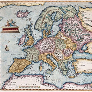
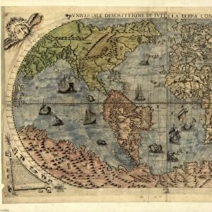
Orteliuss world map, 1570
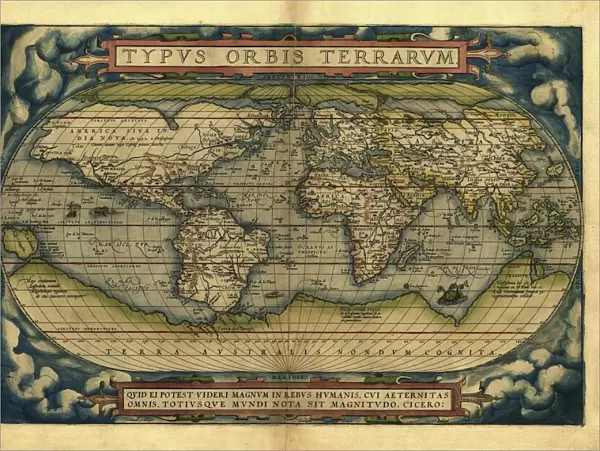
Orteliuss world map. This world map is from the 1570 first edition of Theatrum orbis terrarum ( Theatre of the World ). Drawn by the Flemish mapmaker Abraham Ortelius (1527-1598), and published by Gilles Coppens de Diest in Antwerp, this collection of 53 maps is considered to be the first true modern atlas
Science Photo Library features Science and Medical images including photos and illustrations
Media ID 6298575
© LIBRARY OF CONGRESS, GEOGRAPHY AND MAP DIVISION/SCIENCE PHOTO LIBRARY
1500s 1570 1570 Edition 16th Century Abraham Ortelius Age Of Discovery Antwerp Edition Cartographic Cartography Dutch First Edition First Modern Atlas Flemish Gilles Coppens De Diest Global Latin Latin Edition Orteliuss Text Theatre Of The World Theatrum Orbis Terrarum World World Wide Writing
18x24 inch Poster Print
"Step back in time with our exquisite selection of poster prints from the Science Photo Library. This captivating piece showcases the "Ortelius World Map, 1570," a historic masterpiece by Flemish cartographer Abraham Ortelius. The first edition of his renowned work, "Theatrum orbis terrarum" (Theatre of the World), brings the intrigue of the Renaissance era right to your walls. Delight in the meticulous details and explore the world as it was known over 450 years ago. Each print is produced with premium quality materials, ensuring a stunning addition to any room in your home or office."
Poster prints are budget friendly enlarged prints in standard poster paper sizes. Printed on 150 gsm Matte Paper for a natural feel and supplied rolled in a tube. Great for framing and should last many years. To clean wipe with a microfiber, non-abrasive cloth or napkin. Our Archival Quality Photo Prints and Fine Art Paper Prints are printed on higher quality paper and the choice of which largely depends on your budget.
Poster prints are budget friendly enlarged prints in standard poster paper sizes (A0, A1, A2, A3 etc). Whilst poster paper is sometimes thinner and less durable than our other paper types, they are still ok for framing and should last many years. Our Archival Quality Photo Prints and Fine Art Paper Prints are printed on higher quality paper and the choice of which largely depends on your budget.
Estimated Product Size is 61.6cm x 46.3cm (24.3" x 18.2")
These are individually made so all sizes are approximate
Artwork printed orientated as per the preview above, with landscape (horizontal) orientation to match the source image.
FEATURES IN THESE COLLECTIONS
> Arts
> Artists
> O
> Abraham Ortelius
> Maps and Charts
> Abraham Ortelius
> Maps and Charts
> Early Maps
> Maps and Charts
> Related Images
> Maps and Charts
> World
EDITORS COMMENTS
This print showcases Orteliuss world map, a remarkable piece of cartographic art from the 16th century. Created by Abraham Ortelius, a renowned Flemish mapmaker, this particular world map is part of the first edition of Theatrum orbis terrarum (Theatre of the World), published in 1570 by Gilles Coppens de Diest in Antwerp. Comprising a collection of 53 maps, this work is widely regarded as the first true modern atlas. It represents a significant milestone in the field of geography and cartography during the Age of Discovery. With intricate details and precise craftsmanship, Ortelius beautifully depicts various regions across the globe. The Latin text accompanying the illustrations adds an air of authenticity to this historical masterpiece. As we gaze upon this ancient artifact, we are transported back to a time when explorers were embarking on daring voyages to uncover new lands and expand our understanding of Earth's vastness. This print not only captures an exquisite artwork but also serves as a reminder that maps have always played an essential role in shaping our perception and knowledge about our planet. It symbolizes humanity's insatiable curiosity for exploration and discovery throughout history. Whether you are fascinated by European history or simply appreciate fine art with historical significance, this print offers a glimpse into both worlds – blending aesthetics with intellectual enlightenment.
MADE IN THE USA
Safe Shipping with 30 Day Money Back Guarantee
FREE PERSONALISATION*
We are proud to offer a range of customisation features including Personalised Captions, Color Filters and Picture Zoom Tools
SECURE PAYMENTS
We happily accept a wide range of payment options so you can pay for the things you need in the way that is most convenient for you
* Options may vary by product and licensing agreement. Zoomed Pictures can be adjusted in the Cart.