Premium Framed Print > Europe > Spain > Related Images
Premium Framed Print : Roman empire map 1875


![]()
Framed Photos from Fine Art Storehouse
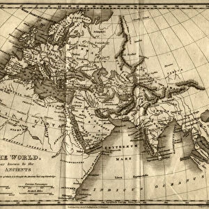
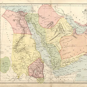
Roman empire map 1875
The Independent Course Comprehensive Geography by James Monteith, A.S. Barnes & Co, New York & Chicago 1875
Unleash your creativity and transform your space into a visual masterpiece!
THEPALMER
Media ID 13612221
© This content is subject to copyright
Britannia Byzantine Egypt Empire Middle East Roman Rome Byzantium Dacia Drawing Art Product
14"x18" Premium Frame
Contemporary style Premium Wooden Frame with 8"x12" Print. Complete with 2" White Mat and 1.25" thick MDF frame. Printed on 260 gsm premium paper. Glazed with shatter proof UV coated acrylic glass. Backing is paper covered backing with rubber bumpers. Supplied ready to hang with a pre-installed sawtooth/wire hanger. Care Instructions: Spot clean with a damp cloth. Securely packaged in a clear plastic bag and envelope in a reinforced cardboard shipper
FSC Real Wood Frame and Double Mounted with White Conservation Mountboard - Professionally Made and Ready to Hang
Estimated Image Size (if not cropped) is 30.4cm x 20.3cm (12" x 8")
Estimated Product Size is 45.8cm x 35.6cm (18" x 14")
These are individually made so all sizes are approximate
Artwork printed orientated as per the preview above, with landscape (horizontal) orientation to match the source image.
FEATURES IN THESE COLLECTIONS
> Fine Art Storehouse
> The Magical World of Illustration
> Palmer Illustrated Collection
> Fine Art Storehouse
> Map
> Historical Maps
> Europe
> Spain
> Related Images
> North America
> United States of America
> New York
> Related Images
EDITORS COMMENTS
This print showcases a historical gem, the "Roman Empire Map 1875" taken from James Monteith's renowned work, "The Independent Course Comprehensive Geography". Published in New York and Chicago by A. S. Barnes & Co. , this exquisite piece of art takes us on a visual journey through the vast territories once ruled by the mighty Roman Empire. With meticulous detail and precision, this horizontal illustration beautifully captures Britannia, Byzantium, Dacia, Egypt, Spain, and other significant regions that were part of this ancient empire. The intricate etching and engraving techniques used to create this masterpiece add depth and texture to every stroke. As we gaze upon this remarkable drawing art product by THEPALMER from Fine Art Storehouse, we are transported back in time to an era filled with grandeur and power. The map not only serves as a geographical representation but also provides valuable insights into the political boundaries of that period. From the Middle East to USA's eastern coastlines lies evidence of Rome's influence on civilization. This artwork is a testament to their expansionist ambitions and enduring legacy. It reminds us of how nature shaped these landscapes while simultaneously being transformed by human hands. Whether you're an avid history enthusiast or simply appreciate fine craftsmanship, this Roman Empire Map 1875 print is sure to captivate your imagination and transport you back in time to one of history's most influential empires - truly a treasure for any art collector or lover of antiquity.
MADE IN THE USA
Safe Shipping with 30 Day Money Back Guarantee
FREE PERSONALISATION*
We are proud to offer a range of customisation features including Personalised Captions, Color Filters and Picture Zoom Tools
SECURE PAYMENTS
We happily accept a wide range of payment options so you can pay for the things you need in the way that is most convenient for you
* Options may vary by product and licensing agreement. Zoomed Pictures can be adjusted in the Cart.