Premium Framed Print > Arts > Landscape paintings > Landscape art > Landscape paintings
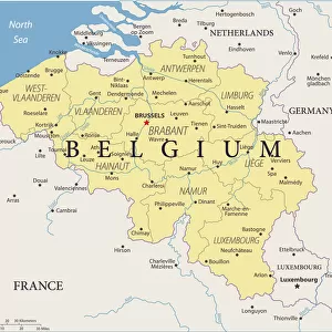
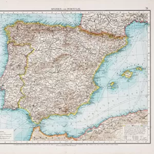
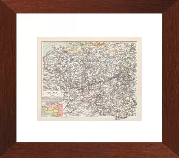
Premium Framed Print : Map of Belgium, lithograph, published in 1897


![]()
Framed Photos from Fine Art Storehouse
Map of Belgium, lithograph, published in 1897
Map of Belgium with the territorial language areas. Lithograph, published in 1897
Unleash your creativity and transform your space into a visual masterpiece!
Media ID 14756378
© This content is subject to copyright
Aachen Antwerp Belgian Culture Belgium Benelux Bruges Brussels Colorful Country European Culture Flanders Gent Luxembourg North Sea Topographic Map Topography Brabant Flemings Liege Lille Netherland
14"x16" Premium Frame
Contemporary style Premium Wooden Frame with 8"x10" Print. Complete with 2" White Mat and 1.25" thick MDF frame. Printed on 260 gsm premium paper. Glazed with shatter proof UV coated acrylic glass. Backing is paper covered backing with rubber bumpers. Supplied ready to hang with a pre-installed sawtooth/wire hanger. Care Instructions: Spot clean with a damp cloth. Securely packaged in a clear plastic bag and envelope in a reinforced cardboard shipper
FSC Real Wood Frame and Double Mounted with White Conservation Mountboard - Professionally Made and Ready to Hang
Estimated Image Size (if not cropped) is 25.4cm x 20.3cm (10" x 8")
Estimated Product Size is 40.6cm x 35.6cm (16" x 14")
These are individually made so all sizes are approximate
Artwork printed orientated as per the preview above, with landscape (horizontal) orientation to match the source image.
FEATURES IN THESE COLLECTIONS
> Fine Art Storehouse
> Map
> Historical Maps
> Arts
> Landscape paintings
> Landscape art
> Landscape paintings
> Europe
> Belgium
> Related Images
EDITORS COMMENTS
This vibrant lithograph, published in 1897, showcases a detailed Map of Belgium with its territorial language areas. A true testament to Belgian culture and history, this print captures the essence of this country nestled in the heart of Europe. From the picturesque cities of Bruges and Brussels to the bustling ports of Antwerp and Gent, every corner is meticulously depicted on this topographic map. The influence from neighboring countries such as France, Germany, and Luxembourg is evident through their close proximity to Belgium's borders. The enchanting region of Flanders stands out with its rich Flemish heritage while Brabant exudes charm with its historic towns. As you trace your finger along the coastline that meets the North Sea, it becomes apparent why Belgium has been a hub for trade throughout history. This horizontal landscape engraving not only serves as a geographical reference but also offers an insight into European culture at that time. Its colorful palette brings life to each city and town represented on this historical piece. Whether you are an avid collector or simply fascinated by maps, this lithograph provides a window into Belgium's past. It encapsulates both the beauty of nature and human-made structures within one frame—a true treasure for any admirer of fine art or lover of Belgian history.
MADE IN THE USA
Safe Shipping with 30 Day Money Back Guarantee
FREE PERSONALISATION*
We are proud to offer a range of customisation features including Personalised Captions, Color Filters and Picture Zoom Tools
SECURE PAYMENTS
We happily accept a wide range of payment options so you can pay for the things you need in the way that is most convenient for you
* Options may vary by product and licensing agreement. Zoomed Pictures can be adjusted in the Cart.