Premium Framed Print > Arts > Photorealistic artworks > Detailed art pieces > Masterful detailing in art
Premium Framed Print : General Map of Kherson Province: Showing Postal and Major Roads, Stations and... 1821. Creators: Vasilii Petrovich Piadyshev, Faleleef


![]()
Framed Photos from Heritage Images
General Map of Kherson Province: Showing Postal and Major Roads, Stations and... 1821. Creators: Vasilii Petrovich Piadyshev, Faleleef
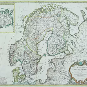
General Map of Kherson Province: Showing Postal and Major Roads, Stations and the Distance in Versts between Them, 1821. This 1821 map of Kherson Provinceis from a larger work, Geograficheskii atlas Rossiiskoi imperii, tsarstva Pol'skogo i velikogo kniazhestva Finliandskogo(Geographical atlas of the Russian Empire, the Kingdom of Poland, and the Grand Duchy of Finland), containing 60 maps of the Russian Empire. Compiled and engraved by Colonel V.P. Piadyshev, it reflects the detailed mapping carried out by Russian military cartographers in the first quarter of the 19th century. The map shows population centers (six gradations by size), postal stations, roads (four types), provincial and district borders, monasteries, factories, taverns, and customs houses. Distances are shown in versts, a Russian measure, now no longer used, equal to 1.07 kilometers.Legends and place-names are in Russian and French. The territory depicted on the map corresponds to present-day southern Ukraine
Heritage Images features heritage image collections
Media ID 35128329
© Heritage Art/Heritage Images
1820s Border Borders Cartographic Cartography Communication Custom House Cyrillic Factories Faleleef Legend Map Making Mapmaking Monasteries Monastery Piadyshev Vasilii Petrovich Population Public House Roads Russian Empire Russian Federation Siberia Russia Tavern Thoroughfare Vasilii Petrovich Piadyshev Vp Piadyshev Meeting Of Frontiers Postal Service
14"x16" Premium Frame
Contemporary style Premium Wooden Frame with 8"x10" Print. Complete with 2" White Mat and 1.25" thick MDF frame. Printed on 260 gsm premium paper. Glazed with shatter proof UV coated acrylic glass. Backing is paper covered backing with rubber bumpers. Supplied ready to hang with a pre-installed sawtooth/wire hanger. Care Instructions: Spot clean with a damp cloth. Securely packaged in a clear plastic bag and envelope in a reinforced cardboard shipper
FSC Real Wood Frame and Double Mounted with White Conservation Mountboard - Professionally Made and Ready to Hang
Estimated Image Size (if not cropped) is 25.4cm x 20.3cm (10" x 8")
Estimated Product Size is 40.6cm x 35.6cm (16" x 14")
These are individually made so all sizes are approximate
Artwork printed orientated as per the preview above, with landscape (horizontal) orientation to match the source image.
FEATURES IN THESE COLLECTIONS
> Animals
> Mammals
> Muridae
> House Mouse
> Arts
> Photorealistic artworks
> Detailed art pieces
> Masterful detailing in art
> Europe
> Finland
> Related Images
> Europe
> Poland
> Related Images
EDITORS COMMENTS
This historic map print, titled "General Map of Kherson Province: Showing Postal and Major Roads, Stations and the Distance in Versts between Them," dates back to 1821. It is an extract from the larger work, "Geograficheskii atlas Rossiiskoi imperii, tsarstva Pol'skogo i velikogo kniazhestva Finliandskogo" (Geographical atlas of the Russian Empire, the Kingdom of Poland, and the Grand Duchy of Finland), which contained 60 maps of the Russian Empire. The map was compiled and engraved by Colonel Vasilii Petrovich Piadyshev and Faleleef. The map provides a detailed representation of Kherson Province in present-day southern Ukraine during the first quarter of the 19th century. It showcases various population centers, six gradations in size, postal stations, roads of four types, provincial and district borders, monasteries, factories, taverns, and customs houses. The distances between these locations are indicated in versts, a Russian measure that equated to approximately 1.07 kilometers. The map's legends and place-names are presented in both Russian and French, reflecting the multinational character of the Russian Empire during that period. The meticulous work carried out by Russian military cartographers is evident in the level of detail captured in this map, offering a fascinating glimpse into the geography and infrastructure of the region over 200 years ago.
MADE IN THE USA
Safe Shipping with 30 Day Money Back Guarantee
FREE PERSONALISATION*
We are proud to offer a range of customisation features including Personalised Captions, Color Filters and Picture Zoom Tools
SECURE PAYMENTS
We happily accept a wide range of payment options so you can pay for the things you need in the way that is most convenient for you
* Options may vary by product and licensing agreement. Zoomed Pictures can be adjusted in the Cart.