Premium Framed Print > Maps and Charts > Abraham Ortelius
Premium Framed Print : Orteliuss map of Switzerland, 1570


![]()
Framed Photos from Science Photo Library
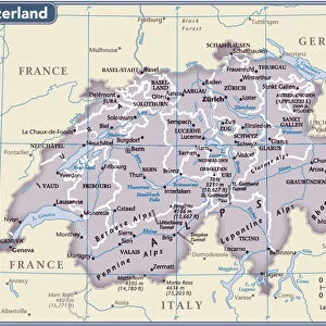
Orteliuss map of Switzerland, 1570
Orteliuss map of Switzerland. This map is from the 1570 first edition of Theatrum orbis terrarum ( Theatre of the World ). Drawn by the Flemish mapmaker Abraham Ortelius (1527-1598), and published by Gilles Coppens de Diest in Antwerp, this collection of 53 maps is considered to be the first true modern atlas
Science Photo Library features Science and Medical images including photos and illustrations
Media ID 6298047
© LIBRARY OF CONGRESS, GEOGRAPHY AND MAP DIVISION/SCIENCE PHOTO LIBRARY
1500s 1570 1570 Edition 16th Century Abraham Ortelius Age Of Discovery Alps Antwerp Edition Cartographic Cartography Country Dutch First Edition First Modern Atlas Flemish Gilles Coppens De Diest Lakes Latin Latin Edition Mountains Nation Orteliuss Swiss Switzerland Text Theatre Of The World Theatrum Orbis Terrarum Writing Confederation Helvetia Helvetic
14"x16" Premium Frame
Contemporary style Premium Wooden Frame with 8"x10" Print. Complete with 2" White Mat and 1.25" thick MDF frame. Printed on 260 gsm premium paper. Glazed with shatter proof UV coated acrylic glass. Backing is paper covered backing with rubber bumpers. Supplied ready to hang with a pre-installed sawtooth/wire hanger. Care Instructions: Spot clean with a damp cloth. Securely packaged in a clear plastic bag and envelope in a reinforced cardboard shipper
FSC Real Wood Frame and Double Mounted with White Conservation Mountboard - Professionally Made and Ready to Hang
Estimated Image Size (if not cropped) is 25.4cm x 20.3cm (10" x 8")
Estimated Product Size is 40.6cm x 35.6cm (16" x 14")
These are individually made so all sizes are approximate
Artwork printed orientated as per the preview above, with landscape (horizontal) orientation to match the source image.
EDITORS COMMENTS
This print showcases Orteliuss map of Switzerland, a remarkable piece from the 1570 first edition of Theatrum orbis terrarum (Theatre of the World). Crafted by the talented Flemish cartographer Abraham Ortelius, this collection of 53 maps is widely regarded as the pioneering modern atlas. Published in Antwerp by Gilles Coppens de Diest, it offers an invaluable glimpse into the geographical and historical landscape of Europe during the 16th century. Intricately illustrated with Latin text and stunning artwork, this map provides a vivid depiction of Switzerland's diverse terrain. From its majestic Alps to its serene lakes, every detail has been meticulously captured on paper. As one explores this cartographic masterpiece, they are transported back to a time when exploration and discovery were at their peak during the Age of Discovery. Helvetia, as Switzerland was known then, emerges as a nation rich in history and natural beauty. This map not only serves as a valuable resource for understanding Swiss geography but also highlights its significance within Europe's larger context. Orteliuss map stands as an enduring testament to his skillful craftsmanship and dedication to accurate representation. Its inclusion in Theatrum orbis terrarum solidifies its place in history as an essential milestone in cartography. With each glance at this extraordinary work of art, we are reminded that maps have always been more than just navigational tools—they are gateways to our past and windows into our world's ever-ev
MADE IN THE USA
Safe Shipping with 30 Day Money Back Guarantee
FREE PERSONALISATION*
We are proud to offer a range of customisation features including Personalised Captions, Color Filters and Picture Zoom Tools
SECURE PAYMENTS
We happily accept a wide range of payment options so you can pay for the things you need in the way that is most convenient for you
* Options may vary by product and licensing agreement. Zoomed Pictures can be adjusted in the Cart.