Premium Framed Print > South America > Related Images
Premium Framed Print : South America, satellite image


![]()
Framed Photos from Science Photo Library
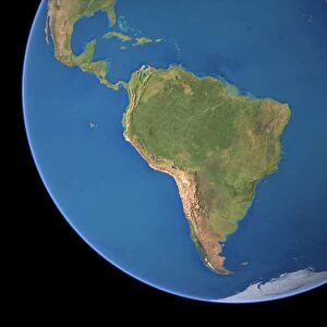
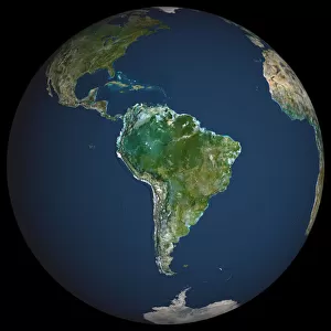
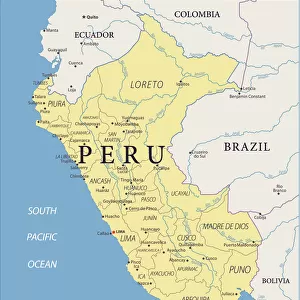
South America, satellite image
South America. Satellite image of South America, showing the borders (white lines) of the countries, and the Caribbean Sea (top right), Pacific Ocean (left) and Atlantic Ocean (right) that surround them. North is at top.. Image compiled from data acquired by LANDSAT satellites, in 2012
Science Photo Library features Science and Medical images including photos and illustrations
Media ID 9217963
© PLANETOBSERVER/SCIENCE PHOTO LIBRARY
2012 Argentina Atlantic Ocean Birds Eye View Bolivia Borders Boundaries Boundary Brasil Brazil Caribbean Sea Cartography Chile Colombia Continent Continents Countries Country Earth Observation Ecuador Elevation Elevations Environmental French Guiana From Above From Space Frontier Frontiers Guyana Land Landsat Nation Nations Oceans Pacific Ocean Peru Satellite Satellite Image Suriname Topographic Topography Venezuela Borer Paraguay Uruguay
14"x16" Premium Frame
Contemporary style Premium Wooden Frame with 8"x10" Print. Complete with 2" White Mat and 1.25" thick MDF frame. Printed on 260 gsm premium paper. Glazed with shatter proof UV coated acrylic glass. Backing is paper covered backing with rubber bumpers. Supplied ready to hang with a pre-installed sawtooth/wire hanger. Care Instructions: Spot clean with a damp cloth. Securely packaged in a clear plastic bag and envelope in a reinforced cardboard shipper
FSC Real Wood Frame and Double Mounted with White Conservation Mountboard - Professionally Made and Ready to Hang
Estimated Image Size (if not cropped) is 20.3cm x 25.4cm (8" x 10")
Estimated Product Size is 35.6cm x 40.6cm (14" x 16")
These are individually made so all sizes are approximate
Artwork printed orientated as per the preview above, with portrait (vertical) orientation to match the source image.
FEATURES IN THESE COLLECTIONS
> North America
> Related Images
> South America
> Peru
> Related Images
> South America
> Related Images
EDITORS COMMENTS
This satellite image print showcases the breathtaking beauty of South America from a unique perspective. Taken in 2012 by LANDSAT satellites, this remarkable composition presents an intricate tapestry of nations and natural wonders. The white lines elegantly trace the borders between countries, revealing the diverse landscapes that define this continent. From the top right corner, we catch a glimpse of the Caribbean Sea with its azure waters shimmering under the sun's gentle caress. To the left lies the vast expanse of the Pacific Ocean, while on the right stretches out the mighty Atlantic Ocean. These majestic bodies of water encircle South America like protective guardians. As our eyes wander across this mesmerizing image, we are reminded of South America's rich geographical diversity. From Uruguay to Brazil, Argentina to Ecuador, Chile to Peru - each country possesses its own distinct charm and allure. The varied topography is evident as mountains rise majestically alongside sprawling plains and dense rainforests teeming with life. This print not only captures Earth's stunning beauty but also serves as a testament to human ingenuity in capturing such awe-inspiring images from space. It invites us to contemplate our place within this vast world and appreciate both its delicate ecosystems and boundless potential for exploration.
MADE IN THE USA
Safe Shipping with 30 Day Money Back Guarantee
FREE PERSONALISATION*
We are proud to offer a range of customisation features including Personalised Captions, Color Filters and Picture Zoom Tools
SECURE PAYMENTS
We happily accept a wide range of payment options so you can pay for the things you need in the way that is most convenient for you
* Options may vary by product and licensing agreement. Zoomed Pictures can be adjusted in the Cart.