Home > North America > Belize > Maps
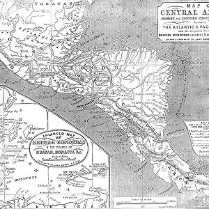
Topographic view of Central America

![]()
Wall Art and Photo Gifts from Stocktrek
Topographic view of Central America
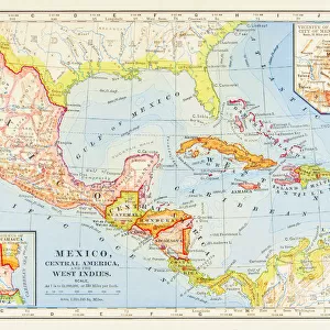
Panama, Costa Rica, Nicaragua, El Salvador, Honduras, Guatemala, Belize, southern Mexico and parts of Cuba and Jamaica are all seen in this image from the Shuttle Radar Topography Mission. The dominant feature of the northern part of Central America is the Sierra Madre Range, spreading east from Mexico between the narrow Pacific coastal plain and the limestone lowland of the Yucatan Peninsula. Parallel hill ranges sweep across Honduras and extend south, past the Caribbean Mosquito Coast to lakes Managua and Nicaragua. The Cordillera Central rises to the south, gradually descending to Lake Gatun and the Isthmus of Panama. A highly active volcanic belt runs along the Pacific seaboard from Mexico to Costa Rica.
High-quality satellite imagery of Central America has, until now, been difficult to obtain due to persistent cloud cover in this region of the world. The ability of SRTM to penetrate clouds and make three-dimensional measurements has allowed the generation of the first complete high-resolution topographic map of the entire region. This map was used to generate the image.
Two visualization methods were combined to produce the image: shading and color coding of topographic height. The shade image was derived by computing topographic slope in the north-south direction. Color coding is directly related to topographic height, with green at the lower elevations, rising through yellow, red, and magenta, to white at the highest elevations
Stocktrek Images specializes in Astronomy, Dinosaurs, Medical, Military Forces, Ocean Life, & Sci-Fi
Media ID 13057941
© Stocktrek Images
Belize Cartography Central America Costa Rica Cuba Elevated Guatemala Honduras Jamaica Land Feature Landform Mexico Nicaragua Peninsula Plains Satellite View Topography Yucatan Cordillera Central El Salvador Isthmus Isthmus Of Panama Managua Panama View From Space
FEATURES IN THESE COLLECTIONS
> North America
> Belize
> Maps
> North America
> Costa Rica
> Maps
> North America
> Cuba
> Maps
> North America
> El Salvador
> Lakes
> Related Images
> North America
> El Salvador
> Maps
> North America
> Guatemala
> Lakes
> Related Images
> North America
> Guatemala
> Maps
> North America
> Honduras
> Lakes
> Related Images
> North America
> Honduras
> Maps
> North America
> Jamaica
> Maps
EDITORS COMMENTS
This print showcases a topographic view of Central America, revealing the stunning landscapes and geographical features of this diverse region. From Panama to Belize, and even parts of Cuba and Jamaica, this image from the Shuttle Radar Topography Mission captures it all. The dominant feature in the northern part of Central America is the majestic Sierra Madre Range, which stretches east from Mexico between the narrow Pacific coastal plain and the limestone lowland of the Yucatan Peninsula. As we explore further south, parallel hill ranges sweep across Honduras before extending past the Caribbean Mosquito Coast to lakes Managua and Nicaragua. The Cordillera Central rises to the south, gradually descending towards Lake Gatun and eventually leading us to the iconic Isthmus of Panama. Alongside these breathtaking landforms lies a highly active volcanic belt that runs along the Pacific seaboard from Mexico all the way down to Costa Rica. What makes this image truly remarkable is its high-resolution quality achieved through advanced satellite technology. Previously hindered by persistent cloud cover in this region, obtaining clear satellite imagery was challenging until now. Thanks to SRTM's ability to penetrate clouds and make three-dimensional measurements, we can now enjoy an unprecedented complete topographic map of Central America. The visualization methods used in creating this image are equally impressive - combining shading with color coding based on topographic height. Shades were derived by computing topographic slope in a north-south direction while colors directly correspond to elevation levels; green for lower elevations rising through yellow, red, magenta until reaching white at highest peaks. This extraordinary piece was brought to you by Stocktrek Images - an awe-inspiring representation capturing both beauty and scientific significance simultaneously.
MADE IN THE USA
Safe Shipping with 30 Day Money Back Guarantee
FREE PERSONALISATION*
We are proud to offer a range of customisation features including Personalised Captions, Color Filters and Picture Zoom Tools
SECURE PAYMENTS
We happily accept a wide range of payment options so you can pay for the things you need in the way that is most convenient for you
* Options may vary by product and licensing agreement. Zoomed Pictures can be adjusted in the Cart.