Canvas Print > Europe > Italy > Emilia-Romagna > Ravenna
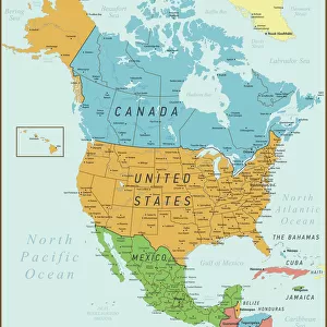
Canvas Print : Geography: representation of the Gulf of Mexico with the coasts of Mexico, Yucatan, Florida and Cuba (Antilles). Map taken from an Atlas of American Odds by Pieter Vander AA based on the description of Franciscus de Garay in 1519, 1728
. Map taken from an Atlas of American Odds by Pieter Vander AA based on the description of Franciscus de Garay in 1519, 1728")

. Map taken from an Atlas of American Odds by Pieter Vander AA based on the description of Franciscus de Garay in 1519, 1728")


![]()
Canvas Prints from Fine Art Finder
Geography: representation of the Gulf of Mexico with the coasts of Mexico, Yucatan, Florida and Cuba (Antilles). Map taken from an Atlas of American Odds by Pieter Vander AA based on the description of Franciscus de Garay in 1519, 1728
VEN5031179 Geography: representation of the Gulf of Mexico with the coasts of Mexico, Yucatan, Florida and Cuba (Antilles). Map taken from an Atlas of American Odds by Pieter Vander AA based on the description of Franciscus de Garay in 1519, 1728. Biblioteca Jose Marti, Havana, Cuba.; (add.info.: Geography: representation of the Gulf of Mexico with the coasts of Mexico, Yucatan, Florida and Cuba (Antilles). Map taken from an Atlas of American Odds by Pieter Vander AA based on the description of Franciscus de Garay in 1519, 1728. Biblioteca Jose Marti, Havana, Cuba.); Photo © Marco Ravenna
Media ID 38484948
© © Marco Ravenna / Bridgeman Images
Amerique Centrale Amerique Du Nord Caraïbes Caribbean Caribbean Island Carte Geographique Central America Etats Unis Geographie Mexicans Mexico Mexican Mexique Stockravenna 18eme Siecle Geographical Map
30"x20" (76x51cm) Canvas Print
Explore the beauty and history of the Gulf of Mexico with our stunning canvas print featuring a vintage map from Fine Art Finder. Perfect for adding a touch of sophistication to any space.
Delivered stretched and ready to hang our premium quality canvas prints are made from a polyester/cotton blend canvas and stretched over a 1.25" (32mm) kiln dried knot free wood stretcher bar. Packaged in a plastic bag and secured to a cardboard insert for safe transit.
Canvas Prints add colour, depth and texture to any space. Professionally Stretched Canvas over a hidden Wooden Box Frame and Ready to Hang
Estimated Product Size is 76.2cm x 50.8cm (30" x 20")
These are individually made so all sizes are approximate
Artwork printed orientated as per the preview above, with landscape (horizontal) orientation to match the source image.
FEATURES IN THESE COLLECTIONS
> Europe
> Italy
> Emilia-Romagna
> Ravenna
> Maps and Charts
> Early Maps
> Maps and Charts
> Related Images
> North America
> Cuba
> Cuba Heritage Sites
> Old Havana and its Fortification System
> North America
> Cuba
> Havana
> North America
> Cuba
> Maps
> North America
> Cuba
> Related Images
> North America
> Mexico
> Maps
> North America
> Mexico
> Related Images
> Fine Art Finder
> Artists
> Jacques de Lajoue
EDITORS COMMENTS
This stunning print captures a historical representation of the Gulf of Mexico, showcasing the coasts of Mexico, Yucatan, Florida, and Cuba (Antilles). The map is taken from an Atlas of American Odds by Pieter Vander AA, based on the description provided by Franciscus de Garay in 1519. This piece offers a glimpse into the geographical knowledge and cartography of the 18th century.
The intricate details on this map highlight the early exploration and understanding of these regions in Central America and North America. It serves as a valuable historical artifact that sheds light on how these areas were perceived centuries ago.
The engraving beautifully showcases the layout of land masses, coastlines, and bodies of water in a style typical of maps from that era. The inclusion of Cuba adds to the richness and complexity depicted in this geography.
Overall, this print not only serves as a visual delight but also as an educational tool for those interested in history, geography, and cartography. It is a testament to human curiosity and exploration throughout time.
MADE IN THE USA
Safe Shipping with 30 Day Money Back Guarantee
FREE PERSONALISATION*
We are proud to offer a range of customisation features including Personalised Captions, Color Filters and Picture Zoom Tools
SECURE PAYMENTS
We happily accept a wide range of payment options so you can pay for the things you need in the way that is most convenient for you
* Options may vary by product and licensing agreement. Zoomed Pictures can be adjusted in the Cart.