Home > North America > Antigua and Barbuda > Maps
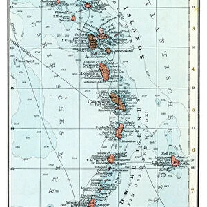
Geography map: representation of the main British islands of the Caribbean Sea (Antigua, Barbados, Jamaican, Bermuda, St. Christopher Island or St. Kitts) from an Atlas of Charles Price, beginning of the 18th century. Biblioteca Angelica, Rome
 from an Atlas of Charles Price, beginning of the 18th century. Biblioteca Angelica, Rome")
![]()
Wall Art and Photo Gifts from Fine Art Finder
Geography map: representation of the main British islands of the Caribbean Sea (Antigua, Barbados, Jamaican, Bermuda, St. Christopher Island or St. Kitts) from an Atlas of Charles Price, beginning of the 18th century. Biblioteca Angelica, Rome
VEN5030269 Geography map: representation of the main British islands of the Caribbean Sea (Antigua, Barbados, Jamaican, Bermuda, St. Christopher Island or St. Kitts) from an Atlas of Charles Price, beginning of the 18th century. Biblioteca Angelica, Rome; (add.info.: Geography map: representation of the main British islands of the Caribbean Sea (Antigua, Barbados, Jamaican, Bermuda, St. Christopher Island or St. Kitts) from an Atlas of Charles Price, beginning of the 18th century. Biblioteca Angelica, Rome); © Marage Photos
Media ID 38350268
© © Marage Photos / Bridgeman Images
Amerique Centrale Amerique Du Nord Caraïbes Caribbean Caribbean Island Carte Geographique Central America Etats Unis Geographie Jamaica Jamaican Stockravenna 18eme Siecle Geographical Map
FEATURES IN THESE COLLECTIONS
> Europe
> Italy
> Lazio
> Rome
> Fine Art Finder
> Artists
> Francois Xavier Fabre
> Maps and Charts
> Early Maps
> Maps and Charts
> Related Images
> North America
> Antigua and Barbuda
> Maps
> North America
> Barbados
> Maps
> North America
> Barbados
> Related Images
> North America
> Bermuda
> Maps
> North America
> Bermuda
> Related Images
> North America
> Jamaica
> Maps
EDITORS COMMENTS
This stunning print from the Atlas of Charles Price, dating back to the beginning of the 18th century, offers a detailed representation of the main British islands in the Caribbean Sea. From Antigua to Barbados, Jamaica to Bermuda, and St. Christopher Island (St. Kitts), this map provides a glimpse into the colonial geography of the time.
The intricate engraving showcases not only the physical features of these islands but also hints at their strategic importance during this period. The inclusion of these specific islands highlights their significance within the British Empire's holdings in the region.
Displayed in Biblioteca Angelica in Rome, this historical map serves as a window into early cartography and exploration efforts that shaped our understanding of these Caribbean territories. The fine details and craftsmanship evident in this print speak to a time when maps were not just tools for navigation but also works of art.
As we gaze upon this piece, we are transported back to an era when discovery and conquest drove European powers to expand their influence across distant lands. It is a reminder of how interconnected our world has always been and how geography has played a crucial role in shaping human history.
MADE IN THE USA
Safe Shipping with 30 Day Money Back Guarantee
FREE PERSONALISATION*
We are proud to offer a range of customisation features including Personalised Captions, Color Filters and Picture Zoom Tools
SECURE PAYMENTS
We happily accept a wide range of payment options so you can pay for the things you need in the way that is most convenient for you
* Options may vary by product and licensing agreement. Zoomed Pictures can be adjusted in the Cart.