Home > South America > Venezuela > Maps
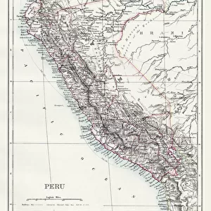
Geography map: representation of the northern part of South America (Brazil, Venezuela, Peru) from the Atlas "" Amerique meridionale" by French cartographer Jean-Baptiste Bourguignon d'Anville (1697-1782), 1748. Biblioteca Angelica, Rome
 from the Atlas '' Amerique meridionale' by French cartographer Jean-Baptiste Bourguignon d'Anville (1697-1782), 1748. Biblioteca Angelica, Rome")
![]()
Wall Art and Photo Gifts from Fine Art Finder
Geography map: representation of the northern part of South America (Brazil, Venezuela, Peru) from the Atlas "" Amerique meridionale" by French cartographer Jean-Baptiste Bourguignon d'Anville (1697-1782), 1748. Biblioteca Angelica, Rome
VEN5030250 Geography map: representation of the northern part of South America (Brazil, Venezuela, Peru) from the Atlas "" Amerique meridionale" by French cartographer Jean-Baptiste Bourguignon d'Anville (1697-1782), 1748. Biblioteca Angelica, Rome; (add.info.: Geography map: representation of the northern part of South America (Brazil, Venezuela, Peru) from the Atlas "" Amerique meridionale" by French cartographer Jean-Baptiste Bourguignon d'Anville (1697-1782), 1748. Biblioteca Angelica, Rome); © Marage Photos
Media ID 38350258
© © Marage Photos / Bridgeman Images
Amerique (continent) Amerique Du Nord Amerique Du Sud Brasil Brazil Brazil Brasilian Brazil Brazilian Brazilian Brazilians Bresil Bresilien Bresilienne Carte Geographique Etats Unis Geographie Latin America Latinamerica Perou Peruvian Southamerica Stockravenna Venezuela Venezuelan
FEATURES IN THESE COLLECTIONS
> Fine Art Finder
> Artists
> Francois Xavier Fabre
> Maps and Charts
> Early Maps
> North America
> United States of America
> Maps
> South America
> Brazil
> Maps
> South America
> Brazil
> Related Images
> South America
> Peru
> Maps
> South America
> Peru
> Related Images
> South America
> Venezuela
> Maps
EDITORS COMMENTS
This stunning print of a geography map, depicting the northern part of South America including Brazil, Venezuela, and Peru, is a true masterpiece from the 18th century. Created by French cartographer Jean-Baptiste Bourguignon d'Anville in 1748, this detailed representation showcases the intricate beauty of the region during that time period.
The map is housed in the Biblioteca Angelica in Rome and provides a glimpse into the geographical knowledge and exploration of the era. With its precise engravings and intricate details, it serves as a valuable historical document for understanding the topography and boundaries of these countries.
From Brazil's vast rainforests to Venezuela's mountainous terrain and Peru's diverse landscapes, this map captures the essence of South America with accuracy and artistry. It highlights not only the physical features but also reflects cultural influences and colonial history prevalent in these regions during that period.
As we admire this piece of cartographic artistry, we are transported back in time to an age when exploration was at its peak and maps were essential tools for navigating unknown territories. The legacy of Jean-Baptiste Bourguignon d'Anville lives on through his meticulous work showcased in this exquisite print.
MADE IN THE USA
Safe Shipping with 30 Day Money Back Guarantee
FREE PERSONALISATION*
We are proud to offer a range of customisation features including Personalised Captions, Color Filters and Picture Zoom Tools
SECURE PAYMENTS
We happily accept a wide range of payment options so you can pay for the things you need in the way that is most convenient for you
* Options may vary by product and licensing agreement. Zoomed Pictures can be adjusted in the Cart.