Home > Europe > Italy > Emilia-Romagna > Ravenna
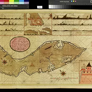
Geography map: depiction of the island of Curacao in the small West Indies, made by Dutch cartographer Gerard van Keulen (1678-1726) 1709-1713. Biblioteca Angelica, Rome
 1709-1713. Biblioteca Angelica, Rome")
![]()
Wall Art and Photo Gifts from Fine Art Finder
Geography map: depiction of the island of Curacao in the small West Indies, made by Dutch cartographer Gerard van Keulen (1678-1726) 1709-1713. Biblioteca Angelica, Rome
VEN5030201 Geography map: depiction of the island of Curacao in the small West Indies, made by Dutch cartographer Gerard van Keulen (1678-1726) 1709-1713. Biblioteca Angelica, Rome; (add.info.: Geography map: depiction of the island of Curacao in the small West Indies, made by Dutch cartographer Gerard van Keulen (1678-1726) 1709-1713. Biblioteca Angelica, Rome); Photo © Marco Ravenna
Media ID 38274428
© © Marco Ravenna / Bridgeman Images
Amerique Centrale Amerique Du Nord Caraïbes Caribbean Caribbean Island Carte Geographique Central America Etats Unis Geographie Stockravenna 18eme Siecle Geographical Map
FEATURES IN THESE COLLECTIONS
> Europe
> Italy
> Emilia-Romagna
> Ravenna
> Europe
> Italy
> Lazio
> Rome
> Fine Art Finder
> Artists
> Marcantonio Bassetti
> Maps and Charts
> Early Maps
> Maps and Charts
> Related Images
> North America
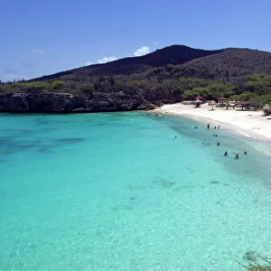
> Curacao
> Maps
> North America
> Curacao
> Related Images
> North America
> United States of America
> Maps
> Popular Themes
> North Island
EDITORS COMMENTS
This stunning print captures a historical geography map depicting the island of Curacao in the small West Indies, created by Dutch cartographer Gerard van Keulen between 1709-1713. The intricate details and precision of this map showcase the skill and artistry of van Keulen during the early 18th century.
The map, housed at Biblioteca Angelica in Rome, offers a glimpse into the past with its depiction of Curacao within the context of central America and the Caribbean. It serves as a valuable historical document, shedding light on the geographical knowledge and exploration of that era.
The engraving showcases not only the physical features of Curacao but also provides insight into how Europeans viewed and understood this part of the world at that time. It is a testament to both scientific curiosity and colonial expansion during this period.
Through this print captured by © Marco Ravenna, viewers can appreciate both the beauty and significance of this rare piece of cartographic history. It stands as a reminder of our ever-evolving understanding of geography and serves as a connection to our past explorations and discoveries.
MADE IN THE USA
Safe Shipping with 30 Day Money Back Guarantee
FREE PERSONALISATION*
We are proud to offer a range of customisation features including Personalised Captions, Color Filters and Picture Zoom Tools
SECURE PAYMENTS
We happily accept a wide range of payment options so you can pay for the things you need in the way that is most convenient for you
* Options may vary by product and licensing agreement. Zoomed Pictures can be adjusted in the Cart.