Home > Europe > Italy > Emilia-Romagna > Ravenna
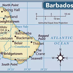
Geography map: representation of Barbados Island in the Caribbean Sea by Dutch cartographer Gerard van Keulen (1678-1726) 1709-1713. Biblioteca Angelica, Rome
 1709-1713. Biblioteca Angelica, Rome")
![]()
Wall Art and Photo Gifts from Fine Art Finder
Geography map: representation of Barbados Island in the Caribbean Sea by Dutch cartographer Gerard van Keulen (1678-1726) 1709-1713. Biblioteca Angelica, Rome
VEN5030212 Geography map: representation of Barbados Island in the Caribbean Sea by Dutch cartographer Gerard van Keulen (1678-1726) 1709-1713. Biblioteca Angelica, Rome; (add.info.: Geography map: representation of Barbados Island in the Caribbean Sea by Dutch cartographer Gerard van Keulen (1678-1726) 1709-1713. Biblioteca Angelica, Rome); Photo © Marco Ravenna
Media ID 38274430
© © Marco Ravenna / Bridgeman Images
Amerique Centrale Amerique Du Nord Caraïbes Caribbean Caribbean Island Carte Geographique Central America Etats Unis Geographie Stockravenna 18eme Siecle Geographical Map
FEATURES IN THESE COLLECTIONS
> Europe
> Italy
> Emilia-Romagna
> Ravenna
> Europe
> Italy
> Lazio
> Rome
> Fine Art Finder
> Artists
> Marcantonio Bassetti
> Maps and Charts
> Early Maps
> Maps and Charts
> Related Images
> North America
> Barbados
> Maps
> North America
> Barbados
> Related Images
> North America
> United States of America
> Maps
> Popular Themes
> North Island
EDITORS COMMENTS
This stunning print captures a historical geography map of Barbados Island in the Caribbean Sea, created by Dutch cartographer Gerard van Keulen between 1709-1713. The intricate details and accuracy of this representation showcase the skill and expertise of van Keulen during the early 18th century.
The map, housed at Biblioteca Angelica in Rome, provides a glimpse into the geographical knowledge and exploration of that time period. It serves as a valuable resource for understanding the layout and features of Barbados Island, as well as its position within the Caribbean region.
Through this image, we are transported back to an era when cartographers meticulously charted uncharted territories and expanded our understanding of the world around us. The delicate engravings on this map highlight not only the physical characteristics of Barbados Island but also offer insights into cultural influences and historical significance.
As we admire this piece of artistry captured by photographer Marco Ravenna, we are reminded of the importance of preserving such historical documents for future generations to appreciate. This geography map is not just a representation of landmasses; it is a testament to human curiosity and ingenuity in exploring new horizons.
MADE IN THE USA
Safe Shipping with 30 Day Money Back Guarantee
FREE PERSONALISATION*
We are proud to offer a range of customisation features including Personalised Captions, Color Filters and Picture Zoom Tools
SECURE PAYMENTS
We happily accept a wide range of payment options so you can pay for the things you need in the way that is most convenient for you
* Options may vary by product and licensing agreement. Zoomed Pictures can be adjusted in the Cart.