Fine Art Print > Europe > Italy > Lazio > Rome
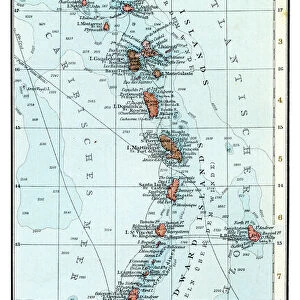
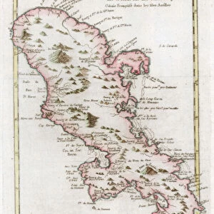
Fine Art Print : Geography map: representation of part of the archipelago of the small Antilles (island of Saint Lucia, Martinique, Dominica, Ile des Saintes, Guadeloupe, Montserrat, Antigua, Barbuda), south east to left and north to right
, south east to left and north to right")


![]()
Fine Art Prints from Fine Art Finder
Geography map: representation of part of the archipelago of the small Antilles (island of Saint Lucia, Martinique, Dominica, Ile des Saintes, Guadeloupe, Montserrat, Antigua, Barbuda), south east to left and north to right
VEN5030211 Geography map: representation of part of the archipelago of the small Antilles (island of Saint Lucia, Martinique, Dominica, Ile des Saintes, Guadeloupe, Montserrat, Antigua, Barbuda), south east to left and north to right, made by Dutch cartographer Gerard van Keulen (1678-1726) 1709-1713 Biblioteca Angelica, Rome; (add.info.: Geography map: representation of part of the archipelago of the small Antilles (island of Saint Lucia, Martinique, Dominica, Ile des Saintes, Guadeloupe, Montserrat, Antigua, Barbuda), south east to left and north to right, made by Dutch cartographer Gerard van Keulen (1678-1726) 1709-1713 Biblioteca Angelica, Rome); © Marage Photos
Media ID 38350242
© © Marage Photos / Bridgeman Images
Amerique Centrale Amerique Du Nord Caraïbes Caribbean Caribbean Island Carte Geographique Central America Etats Unis Geographie Stockravenna 18eme Siecle Geographical Map
21"x14" (+3" Border) Fine Art Print
Explore the stunning beauty of the small Antilles with this captivating geography map Fine Art Print from Media Storehouse. Perfect for adding a touch of wanderlust to any space.
21x14 image printed on 27x20 Fine Art Rag Paper with 3" (76mm) white border. Our Fine Art Prints are printed on 300gsm 100% acid free, PH neutral paper with archival properties. This printing method is used by museums and art collections to exhibit photographs and art reproductions.
Our fine art prints are high-quality prints made using a paper called Photo Rag. This 100% cotton rag fibre paper is known for its exceptional image sharpness, rich colors, and high level of detail, making it a popular choice for professional photographers and artists. Photo rag paper is our clear recommendation for a fine art paper print. If you can afford to spend more on a higher quality paper, then Photo Rag is our clear recommendation for a fine art paper print.
Estimated Image Size (if not cropped) is 53.3cm x 35.5cm (21" x 14")
Estimated Product Size is 68.6cm x 50.8cm (27" x 20")
These are individually made so all sizes are approximate
Artwork printed orientated as per the preview above, with landscape (horizontal) orientation to match the source image.
FEATURES IN THESE COLLECTIONS
> Fine Art Finder
> Artists
> Francois Xavier Fabre
> Europe
> Italy
> Lazio
> Rome
> Maps and Charts
> Early Maps
> Maps and Charts
> Related Images
> North America
> Antigua and Barbuda
> Maps
> North America
> Dominica
> Maps
> North America
> Dominica
> Related Images
> North America
> Guadeloupe
> Maps
> North America
> Guadeloupe
> Related Images
> North America
> Martinique
> Maps
EDITORS COMMENTS
This stunning geography map print showcases a detailed representation of part of the archipelago of the small Antilles, including islands such as Saint Lucia, Martinique, Dominica, Guadeloupe, Montserrat, Antigua, and Barbuda. Created by Dutch cartographer Gerard van Keulen in the early 18th century, this piece is a true masterpiece that captures the beauty and intricacies of these Caribbean islands.
The map is oriented from southeast to left and north to right, providing a unique perspective on the layout of these tropical destinations. The intricate engravings and geographical details make this print not only informative but also visually captivating.
As you study this historical map, you can imagine sailing through the crystal-clear waters surrounding these lush islands or exploring their vibrant cultures and landscapes. Each island is carefully labeled and depicted with precision, offering a glimpse into what life was like in this region centuries ago.
Whether you have a personal connection to these islands or simply appreciate fine cartography and historical artwork, this geography map print is sure to spark your curiosity and imagination. Display it proudly in your home or office as a conversation starter and reminder of the rich history and natural beauty found in the Caribbean.
MADE IN THE USA
Safe Shipping with 30 Day Money Back Guarantee
FREE PERSONALISATION*
We are proud to offer a range of customisation features including Personalised Captions, Color Filters and Picture Zoom Tools
SECURE PAYMENTS
We happily accept a wide range of payment options so you can pay for the things you need in the way that is most convenient for you
* Options may vary by product and licensing agreement. Zoomed Pictures can be adjusted in the Cart.