Fine Art Print > North America > Cuba > Cuba Heritage Sites > Old Havana and its Fortification System
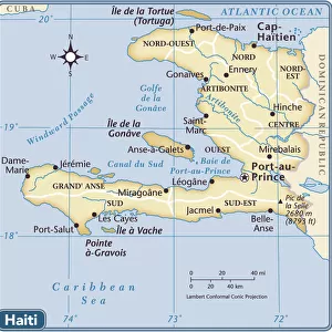
Fine Art Print : Geography Atlas: representation of the island of Hispaniola (which includes Santo Domingo and Haiti) in the Caribbean archipelago. Map by the Knight Lapie, 1819. Biblioteca Jose Marti, Havana, Cuba
 in the Caribbean archipelago. Map by the Knight Lapie, 1819. Biblioteca Jose Marti, Havana, Cuba")


![]()
Fine Art Prints from Fine Art Finder
Geography Atlas: representation of the island of Hispaniola (which includes Santo Domingo and Haiti) in the Caribbean archipelago. Map by the Knight Lapie, 1819. Biblioteca Jose Marti, Havana, Cuba
VEN5031366 Geography Atlas: representation of the island of Hispaniola (which includes Santo Domingo and Haiti) in the Caribbean archipelago. Map by the Knight Lapie, 1819. Biblioteca Jose Marti, Havana, Cuba.; (add.info.: Geography Atlas: representation of the island of Hispaniola (which includes Santo Domingo and Haiti) in the Caribbean archipelago. Map by the Knight Lapie, 1819. Biblioteca Jose Marti, Havana, Cuba.); © Marage Photos
Media ID 38425816
© © Marage Photos / Bridgeman Images
Amerique Centrale Amerique Du Nord Caraïbes Caribbean Caribbean Island Carte Geographique Central America Dominium Etats Unis Geographie Haiti Saint Domingue Stockravenna Geographical Map
20"x16" (+3" Border) Fine Art Print
Explore the rich history and intricate details of the Caribbean with this stunning Fine Art Print showcasing a map of Hispaniola from 1819. Perfect for adding a touch of sophistication to any space, this piece is sure to spark conversation and intrigue among your guests.
20x16 image printed on 26x22 Fine Art Rag Paper with 3" (76mm) white border. Our Fine Art Prints are printed on 300gsm 100% acid free, PH neutral paper with archival properties. This printing method is used by museums and art collections to exhibit photographs and art reproductions.
Our fine art prints are high-quality prints made using a paper called Photo Rag. This 100% cotton rag fibre paper is known for its exceptional image sharpness, rich colors, and high level of detail, making it a popular choice for professional photographers and artists. Photo rag paper is our clear recommendation for a fine art paper print. If you can afford to spend more on a higher quality paper, then Photo Rag is our clear recommendation for a fine art paper print.
Estimated Image Size (if not cropped) is 50.8cm x 35.9cm (20" x 14.1")
Estimated Product Size is 66cm x 55.9cm (26" x 22")
These are individually made so all sizes are approximate
Artwork printed orientated as per the preview above, with landscape (horizontal) orientation to match the source image.
FEATURES IN THESE COLLECTIONS
> Fine Art Finder
> Artists
> Pasquier (workshop of) Grenier
> Maps and Charts
> Early Maps
> Maps and Charts
> Related Images
> North America
> Cuba
> Cuba Heritage Sites
> Old Havana and its Fortification System
> North America
> Cuba
> Havana
> North America
> Cuba
> Maps
> North America
> Cuba
> Related Images
> North America
> Haiti
> Maps
> North America
> Haiti
> Related Images
> North America
> United States of America
> Maps
EDITORS COMMENTS
This stunning print from the Geography Atlas showcases the island of Hispaniola, home to both Santo Domingo and Haiti in the Caribbean archipelago. Created by Knight Lapie in 1819, this map is a true testament to the intricate detail and craftsmanship of cartographers during that time period.
The map can be found in the Biblioteca Jose Marti in Havana, Cuba, adding to its historical significance. The detailed engravings on this map provide a glimpse into what life was like on the island nearly two centuries ago.
As we study this representation of Hispaniola, we are transported back to a time when exploration and discovery were at their peak. The intricate lines and markings on the map tell a story of colonization, trade routes, and natural landmarks that shaped the history of this vibrant island.
From its lush landscapes to its bustling cities, Hispaniola is brought to life through this beautifully preserved piece of art. It serves as a reminder of how geography has played a crucial role in shaping societies throughout history.
Whether you are an avid historian or simply appreciate fine craftsmanship, this print is sure to captivate your imagination and transport you back in time to explore the wonders of Hispaniola.
MADE IN THE USA
Safe Shipping with 30 Day Money Back Guarantee
FREE PERSONALISATION*
We are proud to offer a range of customisation features including Personalised Captions, Color Filters and Picture Zoom Tools
SECURE PAYMENTS
We happily accept a wide range of payment options so you can pay for the things you need in the way that is most convenient for you
* Options may vary by product and licensing agreement. Zoomed Pictures can be adjusted in the Cart.