Home > Maps and Charts > Americas
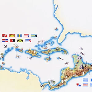
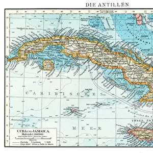
Central America and West Indies map 1875

![]()
Wall Art and Photo Gifts from Fine Art Storehouse
Central America and West Indies map 1875
The Independent Course Comprehensive Geography by James Monteith, A.S. Barnes & Co, New York & Chicago 1875
Unleash your creativity and transform your space into a visual masterpiece!
THEPALMER
Media ID 13612165
© This content is subject to copyright
Antilles Caribbean Central America Cuba Dominican Republic Globe Navigational Equipment Honduras Mexico Nicaragua Panama Paper Puerto Rico West Indies
FEATURES IN THESE COLLECTIONS
> Fine Art Storehouse
> The Magical World of Illustration
> Palmer Illustrated Collection
> Fine Art Storehouse
> Map
> Historical Maps
> Fine Art Storehouse
> Map
> USA Maps
> Maps and Charts
> Early Maps
> Maps and Charts
> World
> North America
> Cuba
> Maps
> North America
> Dominican Republic
> Maps
> North America
> Honduras
> Maps
> North America
> Mexico
> Related Images
> North America
> Nicaragua
> Maps
> North America
> Panama
> Maps
> North America
> Puerto Rico
> Maps
EDITORS COMMENTS
This print showcases a remarkable piece of history - the Central America and West Indies map from 1875. Taken from "The Independent Course Comprehensive Geography" by James Monteith, this antique map provides a glimpse into the past with its intricate details and exquisite craftsmanship. As we gaze upon this print, our eyes are drawn to the vibrant colors that bring life to each country and island depicted. From Cuba to Puerto Rico, Dominican Republic to Mexico, Honduras to Panama, every place is meticulously illustrated on this paper canvas. The etching and engraving techniques used in creating this image further enhance its vintage charm. Transporting us back in time, we can imagine explorers relying on maps like these as they navigated through uncharted territories. This map not only served as a practical tool for travelers but also as an artistic representation of physical geography. It reminds us of the importance placed on cartography during an era when globes were essential navigational equipment. Preserved with care over the years, this old print has become a treasure for enthusiasts of both history and art alike. Its presence evokes nostalgia while offering valuable insights into how our world was perceived more than a century ago. With THEPALMER's skillful photography capturing every detail flawlessly, this print allows us to appreciate the beauty and significance of such historical artifacts without needing commercial intentions or associations with any specific company.
MADE IN THE USA
Safe Shipping with 30 Day Money Back Guarantee
FREE PERSONALISATION*
We are proud to offer a range of customisation features including Personalised Captions, Color Filters and Picture Zoom Tools
SECURE PAYMENTS
We happily accept a wide range of payment options so you can pay for the things you need in the way that is most convenient for you
* Options may vary by product and licensing agreement. Zoomed Pictures can be adjusted in the Cart.