Framed Print > North America > Cuba > Cuba Heritage Sites > Old Havana and its Fortification System
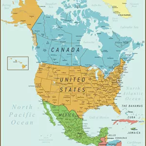
Framed Print : Geography Atlas: representation of the Caribbean Sea, Caribbean Sea (Cuba, Jamaica, Hispaniola), Bahamas Islands, South United States (Florida, Virginia, Carolina). Map taken from an Atlas of the American Coast by the military navy, 1762
, Bahamas Islands, South United States (Florida, Virginia, Carolina). Map taken from an Atlas of the American Coast by the military navy, 1762")
, Bahamas Islands, South United States (Florida, Virginia, Carolina). Map taken from an Atlas of the American Coast by the military navy, 1762")

![]()
Framed Photos from Fine Art Finder
Geography Atlas: representation of the Caribbean Sea, Caribbean Sea (Cuba, Jamaica, Hispaniola), Bahamas Islands, South United States (Florida, Virginia, Carolina). Map taken from an Atlas of the American Coast by the military navy, 1762
VEN5029612 Geography Atlas: representation of the Caribbean Sea, Caribbean Sea (Cuba, Jamaica, Hispaniola), Bahamas Islands, South United States (Florida, Virginia, Carolina). Map taken from an Atlas of the American Coast by the military navy, 1762. Biblioteca Jose Marti, Havana, Cuba.; (add.info.: Geography Atlas: representation of the Caribbean Sea, Caribbean Sea (Cuba, Jamaica, Hispaniola), Bahamas Islands, South United States (Florida, Virginia, Carolina). Map taken from an Atlas of the American Coast by the military navy, 1762. Biblioteca Jose Marti, Havana, Cuba.); © Marage Photos
Media ID 38165890
© © Marage Photos / Bridgeman Images
Amerique Centrale Amerique Du Nord Caraïbes Caribbean Caribbean Island Carte Geographique Central America Cuba Cuba Cubain Cubaine Cubains Cubaines Cuban Etats Unis Geographie Jamaica Jamaican Stockravenna 18eme Siecle Geographical Map
18"x14" Modern Frame
Explore the rich history and intricate details of the Caribbean Sea with this stunning framed print from Media Storehouse. Featuring a vintage map from 1762, this piece is perfect for adding a touch of sophistication to any space.
16x12 Print in an MDF Wooden Frame with 180 gsm Satin Finish Paper. Glazed using shatter proof thin plexiglass. Frame thickness is 1 inch and depth 0.75 inch. Fluted cardboard backing held with clips. Supplied ready to hang with sawtooth hanger and rubber bumpers. Spot clean with a damp cloth. Packaged foam wrapped in a card.
Contemporary Framed and Mounted Prints - Professionally Made and Ready to Hang
Estimated Image Size (if not cropped) is 40.6cm x 35.6cm (16" x 14")
Estimated Product Size is 45.7cm x 35.6cm (18" x 14")
These are individually made so all sizes are approximate
Artwork printed orientated as per the preview above, with landscape (horizontal) orientation to match the source image.
FEATURES IN THESE COLLECTIONS
> Fine Art Finder
> Artists
> Charles Robert Knight
> Maps and Charts
> Early Maps
> Maps and Charts
> Related Images
> North America
> The Bahamas
> Maps
> North America
> The Bahamas
> Related Images
> North America
> Cuba
> Cuba Heritage Sites
> Old Havana and its Fortification System
> North America
> Cuba
> Havana
> North America
> Cuba
> Maps
> North America
> Cuba
> Related Images
> North America
> Jamaica
> Maps
EDITORS COMMENTS
This stunning print of a Geography Atlas from 1762 showcases the intricate details of the Caribbean Sea, including Cuba, Jamaica, Hispaniola, and the Bahamas Islands. The map also extends to the South United States, highlighting Florida, Virginia, and Carolina.
Taken from an Atlas of the American Coast by the military navy, this historical piece is housed in the Biblioteca Jose Marti in Havana, Cuba. The detailed engraving captures the essence of 18th-century cartography with precision and artistry.
The map serves as a valuable resource for understanding the geographical layout of these regions during that time period. It provides insight into how early explorers navigated through these waters and established settlements along the coastlines.
As we gaze upon this image, we are transported back in time to an era when exploration and discovery were at their peak. The vibrant colors and intricate lines draw us in, inviting us to explore each island and coastline depicted on this fascinating map.
This Geography Atlas print is not just a visual representation but a window into history itself. It reminds us of our connection to these lands and seas that have shaped civilizations for centuries.
MADE IN THE USA
Safe Shipping with 30 Day Money Back Guarantee
FREE PERSONALISATION*
We are proud to offer a range of customisation features including Personalised Captions, Color Filters and Picture Zoom Tools
SECURE PAYMENTS
We happily accept a wide range of payment options so you can pay for the things you need in the way that is most convenient for you
* Options may vary by product and licensing agreement. Zoomed Pictures can be adjusted in the Cart.