Framed Print > Arts > Artists > T > John Tallis
Framed Print : Old Map of British America, or Canada 1851 by John Tallis


![]()
Framed Photos from MapSeeker
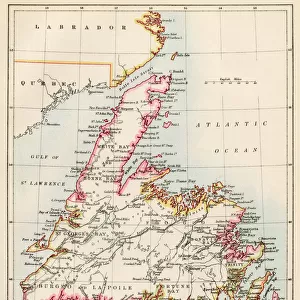
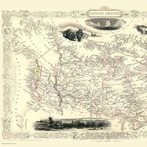
Old Map of British America, or Canada 1851 by John Tallis
A fine facimile artworked from an antique original map of British America or Canada, issued as part of the 1851 edition of John Tallis and Companys " The Illustrated Atlas and Modern History of the World"
Welcome to the Mapseeker Image library and enter an historic gateway to one of the largest on-line collections of Historic Maps, Nostalgic Views, Vista's and Panorama's from a World gone by.
Media ID 20347390
© Mapseeker Publishing Ltd
John Tallis John Tallis Map Tallis Tallis Map British America
18"x14" Modern Frame
Step back in time with our exquisite framed print of the Old Map of British America, or Canada 1851 by John Tallis and John Rapkin from MapSeeker. This fine facsimile artwork is meticulously crafted from an antique original map that was part of the renowned 1851 edition of John Tallis's "The Illustrated Atlas". The intricate details of this historical map showcase the geography and territories of British America and Canada during that era. Add an air of sophistication and history to any room with this beautifully framed and preserved piece. A must-have for collectors, historians, and those who appreciate the beauty of antique maps.
16x12 Print in an MDF Wooden Frame with 180 gsm Satin Finish Paper. Glazed using shatter proof thin plexiglass. Frame thickness is 1 inch and depth 0.75 inch. Fluted cardboard backing held with clips. Supplied ready to hang with sawtooth hanger and rubber bumpers. Spot clean with a damp cloth. Packaged foam wrapped in a card.
Contemporary Framed and Mounted Prints - Professionally Made and Ready to Hang
Estimated Image Size (if not cropped) is 40.6cm x 35.6cm (16" x 14")
Estimated Product Size is 45.7cm x 35.6cm (18" x 14")
These are individually made so all sizes are approximate
Artwork printed orientated as per the preview above, with landscape (horizontal) orientation to match the source image.
FEATURES IN THESE COLLECTIONS
> Arts
> Artists
> T
> John Tallis
> Maps and Charts
> Related Images
> Maps and Charts
> World
> North America
> Canada
> Maps
> North America
> Canada
> Related Images
> MapSeeker
> Maps of the Americas
> Maps of Canada, Newfoundland
EDITORS COMMENTS
This stunning print showcases the "Old Map of British America, or Canada 1851" by John Tallis. A true masterpiece, this fine facsimile artworked from an antique original map takes us back in time to the year 1851. The map was originally issued as part of John Tallis and Company's renowned publication, "The Illustrated Atlas and Modern History of the World". With intricate details and exquisite craftsmanship, this old map offers a fascinating glimpse into the past. It depicts British America or Canada during a significant era in its history. As we explore its contours, we can trace the boundaries of various provinces and territories that formed this vast land. John Tallis's expertise shines through every stroke on this historic cartographic gem. His dedication to accuracy is evident as he captures geographical features with precision while also highlighting important cities, rivers, lakes, and mountain ranges. As we delve deeper into this piece of artistry, it becomes apparent that it holds not only historical significance but also serves as a testament to human curiosity and exploration. This print allows us to appreciate both the beauty of cartography as an art form and the importance of preserving our collective heritage. Whether you are a history enthusiast or simply captivated by vintage maps, this Old Map of British America will undoubtedly transport you back in time while igniting your imagination about how life once thrived across these lands known today as Canada
MADE IN THE USA
Safe Shipping with 30 Day Money Back Guarantee
FREE PERSONALISATION*
We are proud to offer a range of customisation features including Personalised Captions, Color Filters and Picture Zoom Tools
SECURE PAYMENTS
We happily accept a wide range of payment options so you can pay for the things you need in the way that is most convenient for you
* Options may vary by product and licensing agreement. Zoomed Pictures can be adjusted in the Cart.