Photographic Print > Arts > Artists > T > John Tallis
Photographic Print : Old Map of British America, or Canada 1851 by John Tallis


![]()
Photo Prints from MapSeeker
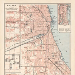
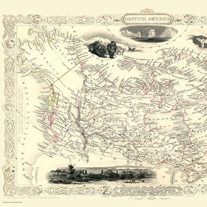
Old Map of British America, or Canada 1851 by John Tallis
A fine facimile artworked from an antique original map of British America or Canada, issued as part of the 1851 edition of John Tallis and Companys " The Illustrated Atlas and Modern History of the World"
Welcome to the Mapseeker Image library and enter an historic gateway to one of the largest on-line collections of Historic Maps, Nostalgic Views, Vista's and Panorama's from a World gone by.
Media ID 20347390
© Mapseeker Publishing Ltd
John Tallis John Tallis Map Tallis Tallis Map British America
11"x8.5" Photo Print
Step back in time with our exquisite Old Map of British America, or Canada 1851 by John Tallis. This stunning reproduction, brought to you by Media Storehouse in collaboration with MapSeeker, is a faithful facsimile of the original antique map issued as part of John Tallis and Company's 1851 Illustrated Atlas. The intricate details and vibrant colors of this historical cartographic masterpiece by renowned mapmakers John Tallis and John Rapkin will transport you to a bygone era. Add an air of sophistication and historical charm to your home or office with this beautiful piece of art. Order now and make history come alive!
Photo prints are produced on Kodak professional photo paper resulting in timeless and breath-taking prints which are also ideal for framing. The colors produced are rich and vivid, with accurate blacks and pristine whites, resulting in prints that are truly timeless and magnificent. Whether you're looking to display your prints in your home, office, or gallery, our range of photographic prints are sure to impress. Dimensions refers to the size of the paper in inches.
Our Photo Prints are in a large range of sizes and are printed on Archival Quality Paper for excellent colour reproduction and longevity. They are ideal for framing (our Framed Prints use these) at a reasonable cost. Alternatives include cheaper Poster Prints and higher quality Fine Art Paper, the choice of which is largely dependant on your budget.
Estimated Image Size (if not cropped) is 27.9cm x 18.6cm (11" x 7.3")
Estimated Product Size is 27.9cm x 21.6cm (11" x 8.5")
These are individually made so all sizes are approximate
Artwork printed orientated as per the preview above, with landscape (horizontal) orientation to match the source image.
FEATURES IN THESE COLLECTIONS
> MapSeeker
> Maps of the Americas
> Maps of Canada, Newfoundland
> Arts
> Artists
> T
> John Tallis
> Maps and Charts
> Related Images
> Maps and Charts
> World
> North America
> Canada
> Maps
> North America
> Canada
> Related Images
EDITORS COMMENTS
This stunning print showcases the "Old Map of British America, or Canada 1851" by John Tallis. A true masterpiece, this fine facsimile artworked from an antique original map takes us back in time to the year 1851. The map was originally issued as part of John Tallis and Company's renowned publication, "The Illustrated Atlas and Modern History of the World". With intricate details and exquisite craftsmanship, this old map offers a fascinating glimpse into the past. It depicts British America or Canada during a significant era in its history. As we explore its contours, we can trace the boundaries of various provinces and territories that formed this vast land. John Tallis's expertise shines through every stroke on this historic cartographic gem. His dedication to accuracy is evident as he captures geographical features with precision while also highlighting important cities, rivers, lakes, and mountain ranges. As we delve deeper into this piece of artistry, it becomes apparent that it holds not only historical significance but also serves as a testament to human curiosity and exploration. This print allows us to appreciate both the beauty of cartography as an art form and the importance of preserving our collective heritage. Whether you are a history enthusiast or simply captivated by vintage maps, this Old Map of British America will undoubtedly transport you back in time while igniting your imagination about how life once thrived across these lands known today as Canada
MADE IN THE USA
Safe Shipping with 30 Day Money Back Guarantee
FREE PERSONALISATION*
We are proud to offer a range of customisation features including Personalised Captions, Color Filters and Picture Zoom Tools
SECURE PAYMENTS
We happily accept a wide range of payment options so you can pay for the things you need in the way that is most convenient for you
* Options may vary by product and licensing agreement. Zoomed Pictures can be adjusted in the Cart.