Poster Print > Arts > Artists > T > John Tallis
Poster Print : Old Map of British America, or Canada 1851 by John Tallis


![]()
Poster Prints from MapSeeker
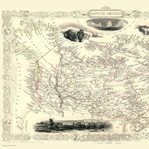
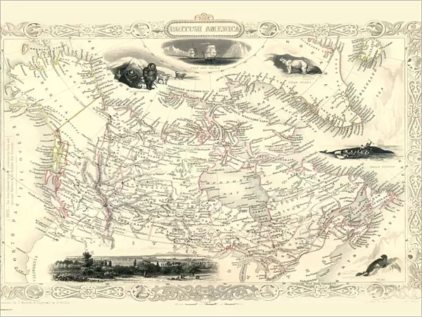
Old Map of British America, or Canada 1851 by John Tallis
A fine facimile artworked from an antique original map of British America or Canada, issued as part of the 1851 edition of John Tallis and Companys " The Illustrated Atlas and Modern History of the World"
Welcome to the Mapseeker Image library and enter an historic gateway to one of the largest on-line collections of Historic Maps, Nostalgic Views, Vista's and Panorama's from a World gone by.
Media ID 20347390
© Mapseeker Publishing Ltd
John Tallis John Tallis Map Tallis Tallis Map British America
18x24 inch Poster Print
Step back in time with our Old Map of British America, or Canada 1851 by John Tallis. This stunning poster print is a faithful reproduction of the antique original map, taken from the 1851 edition of John Tallis and Company's "The Illustrated Atlas." The intricate details of this map, created by John Tallis and John Rapkin, provide a captivating glimpse into the historical geography of North America during the mid-19th century. Add this beautiful piece to your home or office to transport yourself back in time and ignite your sense of adventure. This high-quality poster print is a perfect addition to any space, and a great conversation starter for history enthusiasts and map collectors alike.
Poster prints are budget friendly enlarged prints in standard poster paper sizes. Printed on 150 gsm Matte Paper for a natural feel and supplied rolled in a tube. Great for framing and should last many years. To clean wipe with a microfiber, non-abrasive cloth or napkin. Our Archival Quality Photo Prints and Fine Art Paper Prints are printed on higher quality paper and the choice of which largely depends on your budget.
Poster prints are budget friendly enlarged prints in standard poster paper sizes (A0, A1, A2, A3 etc). Whilst poster paper is sometimes thinner and less durable than our other paper types, they are still ok for framing and should last many years. Our Archival Quality Photo Prints and Fine Art Paper Prints are printed on higher quality paper and the choice of which largely depends on your budget.
Estimated Product Size is 61.6cm x 46.3cm (24.3" x 18.2")
These are individually made so all sizes are approximate
Artwork printed orientated as per the preview above, with landscape (horizontal) orientation to match the source image.
FEATURES IN THESE COLLECTIONS
> MapSeeker
> Maps of the Americas
> Maps of Canada, Newfoundland
> Arts
> Artists
> T
> John Tallis
> Maps and Charts
> Related Images
> Maps and Charts
> World
> North America
> Canada
> Maps
> North America
> Canada
> Related Images
EDITORS COMMENTS
This stunning print showcases the "Old Map of British America, or Canada 1851" by John Tallis. A true masterpiece, this fine facsimile artworked from an antique original map takes us back in time to the year 1851. The map was originally issued as part of John Tallis and Company's renowned publication, "The Illustrated Atlas and Modern History of the World". With intricate details and exquisite craftsmanship, this old map offers a fascinating glimpse into the past. It depicts British America or Canada during a significant era in its history. As we explore its contours, we can trace the boundaries of various provinces and territories that formed this vast land. John Tallis's expertise shines through every stroke on this historic cartographic gem. His dedication to accuracy is evident as he captures geographical features with precision while also highlighting important cities, rivers, lakes, and mountain ranges. As we delve deeper into this piece of artistry, it becomes apparent that it holds not only historical significance but also serves as a testament to human curiosity and exploration. This print allows us to appreciate both the beauty of cartography as an art form and the importance of preserving our collective heritage. Whether you are a history enthusiast or simply captivated by vintage maps, this Old Map of British America will undoubtedly transport you back in time while igniting your imagination about how life once thrived across these lands known today as Canada
MADE IN THE USA
Safe Shipping with 30 Day Money Back Guarantee
FREE PERSONALISATION*
We are proud to offer a range of customisation features including Personalised Captions, Color Filters and Picture Zoom Tools
SECURE PAYMENTS
We happily accept a wide range of payment options so you can pay for the things you need in the way that is most convenient for you
* Options may vary by product and licensing agreement. Zoomed Pictures can be adjusted in the Cart.