Metal Print > Arts > Artists > T > John Tallis
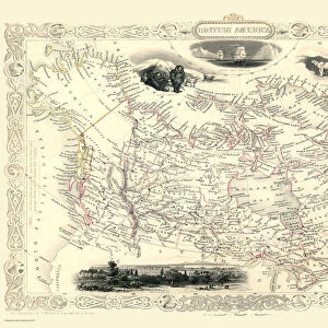
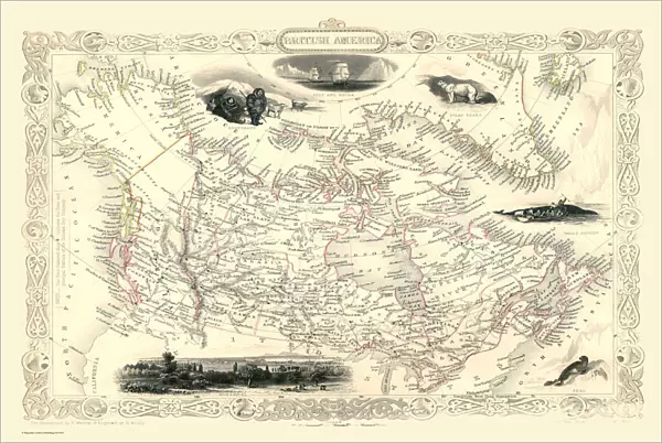
Metal Print : Old Map of British America, or Canada 1851 by John Tallis


![]()
Metal Prints from MapSeeker
Old Map of British America, or Canada 1851 by John Tallis
A fine facimile artworked from an antique original map of British America or Canada, issued as part of the 1851 edition of John Tallis and Companys " The Illustrated Atlas and Modern History of the World"
Welcome to the Mapseeker Image library and enter an historic gateway to one of the largest on-line collections of Historic Maps, Nostalgic Views, Vista's and Panorama's from a World gone by.
Media ID 20347390
© Mapseeker Publishing Ltd
John Tallis John Tallis Map Tallis Tallis Map British America
16"x24" (61x41cm) Metal Print
Discover history with our exquisite Metal Prints featuring the Old Map of British America or Canada, 1851. This stunning reproduction is taken from the original antique map created by John Tallis and John Rapkin for the Illustrated Atlas. Each print is meticulously crafted, bringing the intricate details of this historic map to life. The vibrant colors and high-quality finish of the metal print enhance the beautiful cartography, making it a unique and captivating addition to any home or office decor. Travel back in time and explore the rich history of North America with this timeless piece.
Made with durable metal and luxurious printing techniques, our metal photo prints go beyond traditional canvases, adding a cool, modern touch to your space. Wall mount on back. Eco-friendly 100% post-consumer recycled ChromaLuxe aluminum surface. The thickness of the print is 0.045". Featuring a Scratch-resistant surface and Rounded corners. Backing hangers are attached to the back of the print and float the print 1/2-inch off the wall when hung, the choice of hanger may vary depending on size and International orders will come with Float Mount hangers only. Finished with a brilliant white high gloss surface for unsurpassed detail and vibrance. Printed using Dye-Sublimation and for best care we recommend a non-ammonia glass cleaner, water, or isopropyl (rubbing) alcohol to prevent harming the print surface. We recommend using a clean, lint-free cloth to wipe off the print. The ultra-hard surface is scratch-resistant, waterproof and weatherproof. Avoid direct sunlight exposure.
Made with durable metal and luxurious printing techniques, metal prints bring images to life and add a modern touch to any space
Estimated Product Size is 61.5cm x 41.2cm (24.2" x 16.2")
These are individually made so all sizes are approximate
Artwork printed orientated as per the preview above, with landscape (horizontal) orientation to match the source image.
FEATURES IN THESE COLLECTIONS
> MapSeeker
> Maps of the Americas
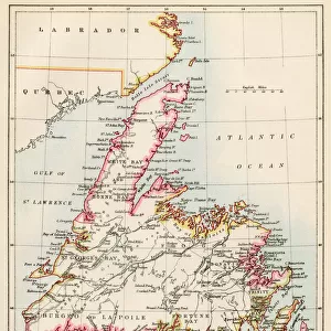
> Maps of Canada, Newfoundland
> Arts
> Artists
> T
> John Tallis
> Maps and Charts
> Related Images
> Maps and Charts
> World
> North America
> Canada
> Maps
> North America
> Canada
> Related Images
EDITORS COMMENTS
This stunning print showcases the "Old Map of British America, or Canada 1851" by John Tallis. A true masterpiece, this fine facsimile artworked from an antique original map takes us back in time to the year 1851. The map was originally issued as part of John Tallis and Company's renowned publication, "The Illustrated Atlas and Modern History of the World". With intricate details and exquisite craftsmanship, this old map offers a fascinating glimpse into the past. It depicts British America or Canada during a significant era in its history. As we explore its contours, we can trace the boundaries of various provinces and territories that formed this vast land. John Tallis's expertise shines through every stroke on this historic cartographic gem. His dedication to accuracy is evident as he captures geographical features with precision while also highlighting important cities, rivers, lakes, and mountain ranges. As we delve deeper into this piece of artistry, it becomes apparent that it holds not only historical significance but also serves as a testament to human curiosity and exploration. This print allows us to appreciate both the beauty of cartography as an art form and the importance of preserving our collective heritage. Whether you are a history enthusiast or simply captivated by vintage maps, this Old Map of British America will undoubtedly transport you back in time while igniting your imagination about how life once thrived across these lands known today as Canada
MADE IN THE USA
Safe Shipping with 30 Day Money Back Guarantee
FREE PERSONALISATION*
We are proud to offer a range of customisation features including Personalised Captions, Color Filters and Picture Zoom Tools
SECURE PAYMENTS
We happily accept a wide range of payment options so you can pay for the things you need in the way that is most convenient for you
* Options may vary by product and licensing agreement. Zoomed Pictures can be adjusted in the Cart.