Home > Arts > Photorealistic artworks > Detailed art pieces > Masterful detailing in art
General Map of the Russian Empire and the Neighboring Polish.. 1827. Creators: Vasilii Petrovich Piadyshev, Ieremin

![]()
Wall Art and Photo Gifts from Heritage Images
General Map of the Russian Empire and the Neighboring Polish.. 1827. Creators: Vasilii Petrovich Piadyshev, Ieremin
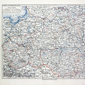
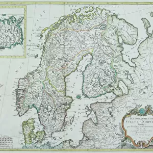
General Map of the Russian Empire and the Neighboring Polish Empire and Grand Duchy of Finland: With the Distance in Versts on Postal Roads between Provincial Cities; and in Boundary Provinces from the Provincial City to County Towns and Foreign Borders; with a Table of Distance in Versts between 73 Notable Cities, 1827. This 1827 map of the Russian Empire is from a larger work, Geograficheskii atlas Rossiiskoi imperii, tsarstva Pol'skogo i velikogo kniazhestva Finliandskogo (Geographical atlas of the Russian Empire, the Kingdom of Poland, and the Grand Duchy of Finland), containing 60 maps of the Russian Empire. It reflects the detailed mapping carried out by Russian military cartographers in the first quarter of the 19th century
Heritage Images features heritage image collections
Media ID 35127795
© Heritage Art/Heritage Images
1820s Alaska United States Of America Atlas Belarus Cartographic Cartography Estland Latvia Legend Lithuania Map Making Mapmaking Military Topographical Depot Piadyshev Vasilii Petrovich Russian Empire Russian Federation Siberia Russia Ukraine Europe Vasilii Petrovich Piadyshev Vp Piadyshev Meeting Of Frontiers
FEATURES IN THESE COLLECTIONS
> Arts
> Photorealistic artworks
> Detailed art pieces
> Masterful detailing in art
> Europe
> Belarus
> Related Images
> Europe
> Estonia
> Related Images
> Europe
> Finland
> Related Images
EDITORS COMMENTS
This stunning 1827 map print depicts the General Map of the Russian Empire and the neighboring Polish-Lithuanian Commonwealth and the Grand Duchy of Finland. Created by Russian military cartographers Vasilii Petrovich Piadyshev and Ieremin, this map is part of a larger work, Geograficheskii atlas Rossiiskoi imperii, tsarstva Pol'skogo i velikogo kniazhestva Finliandskogo (Geographical atlas of the Russian Empire, the Kingdom of Poland, and the Grand Duchy of Finland), which contains 60 maps of the Russian Empire. The map reflects the detailed mapping efforts carried out by the Russian military during the first quarter of the 19th century. It covers a vast area from the Baltic Sea in the west to the Pacific Ocean in the east, including present-day Russia, Belarus, Ukraine, Poland, Estonia, Latvia, Lithuania, and parts of northern Europe and Siberia. The map is rich in detail, with clear labels and a key indicating distances in versts between major cities and towns. The meeting of frontiers between the Russian Empire and its neighbors is clearly marked, highlighting the complex political landscape of the time. The map also includes Alaska, which was then part of the Russian Empire. The use of color and shading adds depth and visual interest to the map, making it a valuable historical and cartographic resource. This map is a testament to the advances in cartography during the 19th century and the efforts of Russian military cartographers to accurately map their vast empire. Today, it is a precious addition to the collections of libraries and institutions, including the Library of Congress and the Congressional Research Service, and a reminder of the rich historical and geographical heritage of Russia and its neighbors.
MADE IN THE USA
Safe Shipping with 30 Day Money Back Guarantee
FREE PERSONALISATION*
We are proud to offer a range of customisation features including Personalised Captions, Color Filters and Picture Zoom Tools
SECURE PAYMENTS
We happily accept a wide range of payment options so you can pay for the things you need in the way that is most convenient for you
* Options may vary by product and licensing agreement. Zoomed Pictures can be adjusted in the Cart.