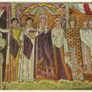
Metal Print > Europe > Italy > Emilia-Romagna > Ravenna
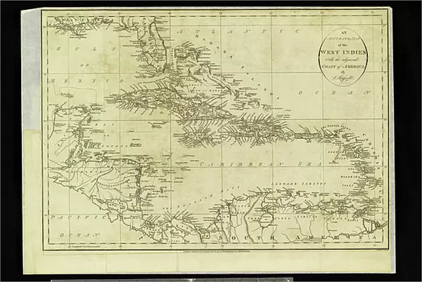
Metal Print : Geographic Atlas: representation of the Caribbean Sea and the Greater Antilles (Cuba, Hispaniola, Puerto Rico and Jamaica), the Bahamas Islands, the South of the United States, the North of South America (Venezuela) and the Lesser Antilles
, the Bahamas Islands, the South of the United States, the North of South America (Venezuela) and the Lesser Antilles")

![]()
Metal Prints from Fine Art Finder
Geographic Atlas: representation of the Caribbean Sea and the Greater Antilles (Cuba, Hispaniola, Puerto Rico and Jamaica), the Bahamas Islands, the South of the United States, the North of South America (Venezuela) and the Lesser Antilles
VEN5029600 Geographic Atlas: representation of the Caribbean Sea and the Greater Antilles (Cuba, Hispaniola, Puerto Rico and Jamaica), the Bahamas Islands, the South of the United States, the North of South America (Venezuela) and the Lesser Antilles. Map from an Atlas of American Odds by J. Rufsell, 1794s. Biblioteca Jose Marti, Havana, Cuba.; (add.info.: Geographic Atlas: representation of the Caribbean Sea and the Greater Antilles (Cuba, Hispaniola, Puerto Rico and Jamaica), the Bahamas Islands, the South of the United States, the North of South America (Venezuela) and the Lesser Antilles. Map from an Atlas of American Odds by J. Rufsell, 1794s. Biblioteca Jose Marti, Havana, Cuba.); Photo © Marco Ravenna
Media ID 38274978
© © Marco Ravenna / Bridgeman Images
Amerique Centrale Amerique Du Nord Caraïbes Caribbean Caribbean Island Carte Geographique Central America Cuba Cuba Cubain Cubaine Cubains Cubaines Cuban Etats Unis Geographie Jamaica Jamaican Stockravenna Venezuela Venezuelan 18eme Siecle Geographical Map
16"x24" (61x41cm) Metal Print
Elevate your space with a touch of adventure! Our Metal Prints feature stunning works like 'Geographic Atlas: representation of the Caribbean Sea...' by Marco Ravenna from Fine Art Finder. This breathtaking piece captures the essence of exploration and discovery, transporting you to a world where sea meets sky. Made with high-quality materials and expert craftsmanship, our metal prints are designed to last for generations to come.
Made with durable metal and luxurious printing techniques, our metal photo prints go beyond traditional canvases, adding a cool, modern touch to your space. Wall mount on back. Eco-friendly 100% post-consumer recycled ChromaLuxe aluminum surface. The thickness of the print is 0.045". Featuring a Scratch-resistant surface and Rounded corners. Backing hangers are attached to the back of the print and float the print 1/2-inch off the wall when hung, the choice of hanger may vary depending on size and International orders will come with Float Mount hangers only. Finished with a brilliant white high gloss surface for unsurpassed detail and vibrance. Printed using Dye-Sublimation and for best care we recommend a non-ammonia glass cleaner, water, or isopropyl (rubbing) alcohol to prevent harming the print surface. We recommend using a clean, lint-free cloth to wipe off the print. The ultra-hard surface is scratch-resistant, waterproof and weatherproof. Avoid direct sunlight exposure.
Made with durable metal and luxurious printing techniques, metal prints bring images to life and add a modern touch to any space
Estimated Product Size is 61.5cm x 41.2cm (24.2" x 16.2")
These are individually made so all sizes are approximate
Artwork printed orientated as per the preview above, with landscape (horizontal) orientation to match the source image.
FEATURES IN THESE COLLECTIONS
> Fine Art Finder
> Artists
> Marcantonio Bassetti
> Europe
> Italy
> Emilia-Romagna
> Ravenna
> Maps and Charts
> Early Maps
> Maps and Charts
> Related Images
> North America
> The Bahamas
> Maps
> North America
> The Bahamas
> Related Images
> North America
> Cuba
> Cuba Heritage Sites
> Old Havana and its Fortification System
> North America
> Cuba
> Havana
> North America
> Cuba
> Maps
> North America
> Cuba
> Related Images
EDITORS COMMENTS
This stunning print captures a piece of history from an 18th-century Geographic Atlas, showcasing the intricate details of the Caribbean Sea and the surrounding islands. The map includes the Greater Antilles such as Cuba, Hispaniola, Puerto Rico, and Jamaica, as well as the Bahamas Islands, the South of the United States, Venezuela in North America, and the Lesser Antilles.
The delicate engravings on this map provide a glimpse into how these regions were perceived centuries ago. Each island is meticulously labeled and depicted with precision, offering a valuable insight into early cartography.
As you study this image closely, you can almost feel yourself being transported back in time to when explorers first navigated these waters and discovered new lands. The rich history of each island comes alive through this detailed representation.
Whether you have a personal connection to any of these locations or simply appreciate historical maps, this print is sure to spark curiosity and admiration for the beauty of our world's geography. Display it proudly in your home or office as a conversation starter and a reminder of the vast wonders that lie beyond our shores.
MADE IN THE USA
Safe Shipping with 30 Day Money Back Guarantee
FREE PERSONALISATION*
We are proud to offer a range of customisation features including Personalised Captions, Color Filters and Picture Zoom Tools
SECURE PAYMENTS
We happily accept a wide range of payment options so you can pay for the things you need in the way that is most convenient for you
* Options may vary by product and licensing agreement. Zoomed Pictures can be adjusted in the Cart.