Metal Print > Europe > Italy > Lazio > Rome
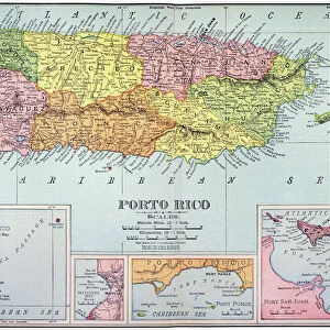
Metal Print : Geography map: representation of the island of Puerto Rico in the Caribbean, made by Dutch cartographer Gerard van Keulen (1678-1726) 1709-1713. Biblioteca Angelica, Rome
 1709-1713. Biblioteca Angelica, Rome")


![]()
Metal Prints from Fine Art Finder
Geography map: representation of the island of Puerto Rico in the Caribbean, made by Dutch cartographer Gerard van Keulen (1678-1726) 1709-1713. Biblioteca Angelica, Rome
VEN5030187 Geography map: representation of the island of Puerto Rico in the Caribbean, made by Dutch cartographer Gerard van Keulen (1678-1726) 1709-1713. Biblioteca Angelica, Rome; (add.info.: Geography map: representation of the island of Puerto Rico in the Caribbean, made by Dutch cartographer Gerard van Keulen (1678-1726) 1709-1713. Biblioteca Angelica, Rome); © Marage Photos
Media ID 38167640
© © Marage Photos / Bridgeman Images
Amerique Centrale Amerique Du Nord Caraïbes Caribbean Caribbean Island Carte Geographique Central America Etats Unis Geographie Stockravenna 18eme Siecle Geographical Map
16"x24" (61x41cm) Metal Print
"Explore the rich history of Puerto Rico with our stunning Metal Print from Bridgeman Images. This beautifully crafted print features a 17th-century map by Dutch cartographer Gerard van Keulen, showcasing the island's geography and topography in exquisite detail. A true masterpiece of cartography, this metal print is perfect for any room in your home or office that needs a touch of elegance and sophistication.
Made with durable metal and luxurious printing techniques, our metal photo prints go beyond traditional canvases, adding a cool, modern touch to your space. Wall mount on back. Eco-friendly 100% post-consumer recycled ChromaLuxe aluminum surface. The thickness of the print is 0.045". Featuring a Scratch-resistant surface and Rounded corners. Backing hangers are attached to the back of the print and float the print 1/2-inch off the wall when hung, the choice of hanger may vary depending on size and International orders will come with Float Mount hangers only. Finished with a brilliant white high gloss surface for unsurpassed detail and vibrance. Printed using Dye-Sublimation and for best care we recommend a non-ammonia glass cleaner, water, or isopropyl (rubbing) alcohol to prevent harming the print surface. We recommend using a clean, lint-free cloth to wipe off the print. The ultra-hard surface is scratch-resistant, waterproof and weatherproof. Avoid direct sunlight exposure.
Made with durable metal and luxurious printing techniques, metal prints bring images to life and add a modern touch to any space
Estimated Product Size is 61.5cm x 41.2cm (24.2" x 16.2")
These are individually made so all sizes are approximate
Artwork printed orientated as per the preview above, with landscape (horizontal) orientation to match the source image.
FEATURES IN THESE COLLECTIONS
> Fine Art Finder
> Artists
> Unknown Artist
> Europe
> Italy
> Lazio
> Rome
> Maps and Charts
> Early Maps
> Maps and Charts
> Related Images
> North America
> Puerto Rico
> Maps
> North America
> Puerto Rico
> Related Images
> North America
> United States of America
> Maps
> Popular Themes
> North Island
EDITORS COMMENTS
This stunning print showcases a historical geography map of the island of Puerto Rico in the Caribbean, created by Dutch cartographer Gerard van Keulen between 1709-1713. The intricate details and accuracy of this map reflect the skill and expertise of van Keulen during the early 18th century.
The representation of Puerto Rico on this map provides a glimpse into the past, offering valuable insights into the geographical features and layout of the island at that time. From its coastlines to its interior regions, every aspect is meticulously depicted with precision and artistry.
As we admire this piece from Biblioteca Angelica in Rome, we are transported back to an era when cartography was not only a science but also an art form. The delicate engravings and intricate lines on this map speak volumes about the dedication and passion that went into creating it.
Through maps like these, we can appreciate how our understanding of geography has evolved over centuries. They serve as reminders of our connection to the land around us and inspire us to explore further beyond what is known.
This geography map is not just a visual representation; it is a testament to human curiosity and ingenuity in exploring new horizons.
MADE IN THE USA
Safe Shipping with 30 Day Money Back Guarantee
FREE PERSONALISATION*
We are proud to offer a range of customisation features including Personalised Captions, Color Filters and Picture Zoom Tools
SECURE PAYMENTS
We happily accept a wide range of payment options so you can pay for the things you need in the way that is most convenient for you
* Options may vary by product and licensing agreement. Zoomed Pictures can be adjusted in the Cart.