Photo Mug > Europe > Italy > Emilia-Romagna > Ravenna
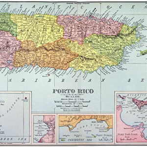
Photo Mug : Geography: Map of Puerto Rico Island, Beata Island, Hispaniola coasts in the West Indies. Map from an Atlas of Maritime Geography of 1767. Biblioteca Jose Marti, Havana, Cuba


![]()
Home Decor from Fine Art Finder
Geography: Map of Puerto Rico Island, Beata Island, Hispaniola coasts in the West Indies. Map from an Atlas of Maritime Geography of 1767. Biblioteca Jose Marti, Havana, Cuba
VEN5031327 Geography: Map of Puerto Rico Island, Beata Island, Hispaniola coasts in the West Indies. Map from an Atlas of Maritime Geography of 1767. Biblioteca Jose Marti, Havana, Cuba; (add.info.: Geography: Map of Puerto Rico Island, Beata Island, Hispaniola coasts in the West Indies. Map from an Atlas of Maritime Geography of 1767. Biblioteca Jose Marti, Havana, Cuba); Photo © Marco Ravenna
Media ID 38484846
© © Marco Ravenna / Bridgeman Images
Amerique Centrale Amerique Du Nord Caraïbes Caribbean Caribbean Island Carte Geographique Central America Etats Unis Geographie Stockravenna 18eme Siecle Geographical Map
Large Photo Mug (15 oz)
Sip your morning coffee in style with our Photo Mug featuring a vintage map of Puerto Rico Island, Beata Island, and Hispaniola coasts in the West Indies. A unique piece of history captured by Marco Ravenna from Fine Art Finder. Add a touch of sophistication to your daily routine with this exclusive design.
Elevate your coffee or tea experience with our premium white ceramic mug. Its wide, comfortable handle makes drinking easy, and you can rely on it to be both microwave and dishwasher safe. Sold in single units, preview may show both sides of the same mug so you can see how the picture wraps around.
Elevate your coffee or tea experience with our premium white ceramic mug. Its wide, comfortable handle makes drinking easy, and you can rely on it to be both microwave and dishwasher safe. Sold in single units, preview may show both sides of the same mug so you can see how the picture wraps around.
These are individually made so all sizes are approximate
FEATURES IN THESE COLLECTIONS
> Fine Art Finder
> Artists
> Pasquier (workshop of) Grenier
> Europe
> Italy
> Emilia-Romagna
> Ravenna
> Maps and Charts
> Early Maps
> Maps and Charts
> Related Images
> North America
> Cuba
> Cuba Heritage Sites
> Old Havana and its Fortification System
> North America
> Cuba
> Havana
> North America
> Cuba
> Maps
> North America
> Cuba
> Related Images
> North America
> Puerto Rico
> Maps
> North America
> Puerto Rico
> Related Images
EDITORS COMMENTS
This stunning print captures a piece of history from the 18th century, showcasing a detailed map of Puerto Rico Island, Beata Island, and the coasts of Hispaniola in the West Indies. The map is taken from an Atlas of Maritime Geography dated back to 1767, highlighting the intricate geographical features of these Caribbean islands.
Displayed at the Biblioteca Jose Marti in Havana, Cuba, this map offers a glimpse into the past and serves as a valuable resource for understanding the maritime landscape of that era. The engraving showcases not only the physical geography but also provides insight into how these islands were perceived and navigated by sailors and explorers centuries ago.
The image is rich with historical significance, representing a time when exploration and discovery shaped our understanding of the world. It reminds us of the interconnectedness between different regions and cultures in Central America and beyond.
Through this print by Marco Ravenna, we are transported back in time to witness firsthand how cartographers meticulously charted out these lands. It serves as a reminder of our ever-evolving relationship with geography and how maps continue to shape our perception of the world around us.
MADE IN THE USA
Safe Shipping with 30 Day Money Back Guarantee
FREE PERSONALISATION*
We are proud to offer a range of customisation features including Personalised Captions, Color Filters and Picture Zoom Tools
SECURE PAYMENTS
We happily accept a wide range of payment options so you can pay for the things you need in the way that is most convenient for you
* Options may vary by product and licensing agreement. Zoomed Pictures can be adjusted in the Cart.