Photographic Print > North America > Dominican Republic > Dominican Republic Heritage Sites > Colonial City of Santo Domingo
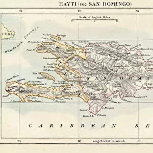
Photographic Print : Geography: map of the island of Santo Domingo (Dominican Republic) in the West Indies. Map from an Atlas of Geography of Mendes, 1858. Biblioteca Jose Marti, Havana, Cuba
 in the West Indies. Map from an Atlas of Geography of Mendes, 1858. Biblioteca Jose Marti, Havana, Cuba")
![]()
Photo Prints from Fine Art Finder
Geography: map of the island of Santo Domingo (Dominican Republic) in the West Indies. Map from an Atlas of Geography of Mendes, 1858. Biblioteca Jose Marti, Havana, Cuba
VEN5031333 Geography: map of the island of Santo Domingo (Dominican Republic) in the West Indies. Map from an Atlas of Geography of Mendes, 1858. Biblioteca Jose Marti, Havana, Cuba; (add.info.: Geography: map of the island of Santo Domingo (Dominican Republic) in the West Indies. Map from an Atlas of Geography of Mendes, 1858. Biblioteca Jose Marti, Havana, Cuba); © Marage Photos
Media ID 38164396
© © Marage Photos / Bridgeman Images
Amerique Centrale Amerique Du Nord Caraïbes Caribbean Caribbean Island Carte Geographique Central America Dominium Etats Unis Geographie Saint Domingue Stockravenna Geographical Map
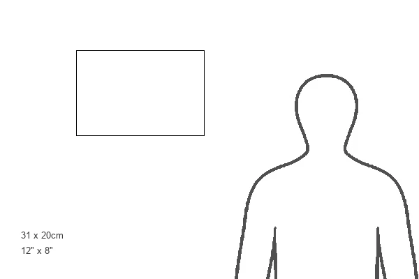
12"x8" Photo Print
Explore the rich history and detailed cartography of the island of Santo Domingo with this vintage map print from Media Storehouse. Perfect for adding a touch of old-world charm to your home decor.
Photo prints are produced on Kodak professional photo paper resulting in timeless and breath-taking prints which are also ideal for framing. The colors produced are rich and vivid, with accurate blacks and pristine whites, resulting in prints that are truly timeless and magnificent. Whether you're looking to display your prints in your home, office, or gallery, our range of photographic prints are sure to impress. Dimensions refers to the size of the paper in inches.
Our Photo Prints are in a large range of sizes and are printed on Archival Quality Paper for excellent colour reproduction and longevity. They are ideal for framing (our Framed Prints use these) at a reasonable cost. Alternatives include cheaper Poster Prints and higher quality Fine Art Paper, the choice of which is largely dependant on your budget.
Estimated Product Size is 30.5cm x 20.3cm (12" x 8")
These are individually made so all sizes are approximate
Artwork printed orientated as per the preview above, with landscape (horizontal) orientation to match the source image.
FEATURES IN THESE COLLECTIONS
> Maps and Charts
> Early Maps
> Maps and Charts
> Related Images
> North America
> Cuba
> Cuba Heritage Sites
> Old Havana and its Fortification System
> North America
> Cuba
> Havana
> North America
> Cuba
> Maps
> North America
> Cuba
> Related Images
> North America
> Dominican Republic
> Dominican Republic Heritage Sites
> Colonial City of Santo Domingo
> North America
> Dominican Republic
> Maps
> North America
> Dominican Republic
> Related Images
EDITORS COMMENTS
This stunning print captures a detailed map of the island of Santo Domingo (Dominican Republic) in the West Indies, dating back to 1858. The map is from an Atlas of Geography by Mendes and is housed in the Biblioteca Jose Marti in Havana, Cuba.
The intricate engraving showcases the geographical features of the island during the 19th century, providing a glimpse into its past. From its lush landscapes to its coastal shores, every detail is meticulously depicted on this historical map.
As we study this piece, we are transported back in time to an era when cartography was both a science and an art form. The precision and craftsmanship that went into creating this map are truly remarkable, serving as a testament to human ingenuity and curiosity about our world.
Through this image, we not only learn about the geography of Santo Domingo but also gain insight into the broader context of Central America and the Caribbean during that period. It serves as a reminder of how interconnected our world has always been and how maps have played a crucial role in shaping our understanding of it.
Overall, this print is not just a visual representation but also a historical artifact that invites us to explore and appreciate the rich tapestry of our planet's past.
MADE IN THE USA
Safe Shipping with 30 Day Money Back Guarantee
FREE PERSONALISATION*
We are proud to offer a range of customisation features including Personalised Captions, Color Filters and Picture Zoom Tools
SECURE PAYMENTS
We happily accept a wide range of payment options so you can pay for the things you need in the way that is most convenient for you
* Options may vary by product and licensing agreement. Zoomed Pictures can be adjusted in the Cart.