Photographic Print > Arts > Artists > O > Abraham Ortelius
Photographic Print : Orteliuss map of Ottoman Empire, 1570


Photo Prints from Science Photo Library
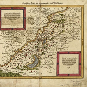
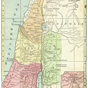
Orteliuss map of Ottoman Empire, 1570
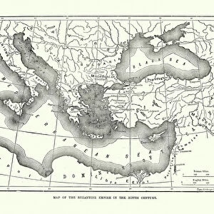
Orteliuss map of the Ottoman Empire. This map is from the 1570 first edition of Theatrum orbis terrarum ( Theatre of the World ). Drawn by the Flemish mapmaker Abraham Ortelius (1527-1598), and published by Gilles Coppens de Diest in Antwerp, this collection of 53 maps is considered to be the first true modern atlas
Science Photo Library features Science and Medical images including photos and illustrations
Media ID 6298063
© LIBRARY OF CONGRESS, GEOGRAPHY AND MAP DIVISION/SCIENCE PHOTO LIBRARY
1500s 1570 1570 Edition 16th Century Abraham Ortelius Africa African Age Of Discovery Antwerp Edition Arab Arabic Cartographic Cartography Country Dutch Empire First Edition First Modern Atlas Flemish Gilles Coppens De Diest Islamic Latin Latin Edition Middle East Moslem Muslim Nation Orteliuss Ottoman Empire Region Text Theatre Of The World Theatrum Orbis Terrarum Turkish Writing Ottoman
10"x8" Photo Print
Discover the rich history of the Ottoman Empire with our exquisite selection of photographic prints from Media Storehouse. This particular print features the Ortelius Map of the Ottoman Empire, taken from the first edition of Theatrum orbis terrarum (Theatre of the World), published in 1570. The intricate details and vibrant colors of this historical map are beautifully captured in our high-quality photographic print. Bring a piece of the past into your home or office and add an air of sophistication and historical significance to any space. This print makes for an excellent conversation starter and a great addition to any collection of historical maps or world geography enthusiasts. Order now and step back in time with Media Storehouse's range of photographic prints.
Photo prints are produced on Kodak professional photo paper resulting in timeless and breath-taking prints which are also ideal for framing. The colors produced are rich and vivid, with accurate blacks and pristine whites, resulting in prints that are truly timeless and magnificent. Whether you're looking to display your prints in your home, office, or gallery, our range of photographic prints are sure to impress. Dimensions refers to the size of the paper in inches.
Our Photo Prints are in a large range of sizes and are printed on Archival Quality Paper for excellent colour reproduction and longevity. They are ideal for framing (our Framed Prints use these) at a reasonable cost. Alternatives include cheaper Poster Prints and higher quality Fine Art Paper, the choice of which is largely dependant on your budget.
Estimated Product Size is 25.4cm x 20.3cm (10" x 8")
These are individually made so all sizes are approximate
Artwork printed orientated as per the preview above, with landscape (horizontal) or portrait (vertical) orientation to match the source image.
FEATURES IN THESE COLLECTIONS
> Africa
> Related Images
> Arts
> Artists
> O
> Abraham Ortelius
> Asia
> Related Images
> Asia
> Turkey
> Related Images
> Maps and Charts
> Abraham Ortelius
> Maps and Charts
> Early Maps
> Maps and Charts
> Popular Maps
> Maps and Charts
> Related Images
> Maps and Charts
> World
EDITORS COMMENTS
This print showcases Orteliuss map of the Ottoman Empire, a remarkable piece from the 1570 first edition of Theatrum orbis terrarum (Theatre of the World). Crafted by the talented Flemish cartographer Abraham Ortelius and published in Antwerp by Gilles Coppens de Diest, this collection of 53 maps is hailed as the pioneering modern atlas. Intricate details adorn this historical masterpiece, providing a glimpse into the world during the 16th century. The Latin text accompanying the map adds an air of authenticity to its composition. With its meticulous depiction of European, African, and Asian regions under Ottoman rule, it serves as a testament to both geographical accuracy and artistic finesse. Transporting us back in time, this artwork sheds light on an era marked by exploration and discovery. It offers valuable insights into how different nations coexisted within one empire - Muslim Arabs alongside Turks - showcasing their diverse cultures and histories. As we delve into this visual treasure trove brimming with history and geography intertwined, we are reminded that maps not only serve practical purposes but also hold immense cultural significance. This particular rendition provides a window into Europe's fascination with distant lands during the Age of Discovery while simultaneously capturing our imagination with its exquisite craftsmanship. Science Photo Library has once again brought forth an invaluable piece that invites us to explore our past through artistry and cartography.
MADE IN THE USA
Safe Shipping with 30 Day Money Back Guarantee
FREE PERSONALISATION*
We are proud to offer a range of customisation features including Personalised Captions, Color Filters and Picture Zoom Tools
SECURE PAYMENTS
We happily accept a wide range of payment options so you can pay for the things you need in the way that is most convenient for you
* Options may vary by product and licensing agreement. Zoomed Pictures can be adjusted in the Cart.